
FCCInfo.com
A Service of Cavell, Mertz & Associates, Inc.
(855) FCC-INFO
|
|
W18DS-D from 03/23/2012 W18DS-D from 09/30/1992 |
|
|
|||||||||||||||||||
|
|
Status: License Application Accepted: 08/03/2023 License Expires: 08/02/2021 File Number: -0000218896 FCC Website Links: LMS Facility Details This Application Other W26ET-D Applications Including Superseded Applications Mailing Address Correspondence for W26ET-D Correspondence related to application -0000218896 Service Contour - Open Street Map or USGS Map (51 dBu) Service Contour - KML / Google Earth (51 dBu) Rabbit Ears Info Search for W26ET-D Site Location: 35-12-36.0 N 85-16-42.3 W (NAD 83) Site Location: 35-12-35.7 N 85-16-42.4 W (Converted to NAD 27) ERP: 5 kW Polarization: Elliptically polarized R/C AGL: 64 m (210 ft.) R/C AMSL: 669.3 m (2196 ft.) Emission Mask: Full Service Site Elevation: 605.3 m. (1986 ft.) Height Overall*: 176.5 m (579 ft.) (* As Filed In This Application, may differ from ASR Data, Below.) Directional Antenna - Antenna Make/Model: DIELECTRIC TUM-LP-C1-01/01M Antenna ID: 1010959 Polarization: Elliptically polarized
| |||||||||||||||||||||
| Antenna Data for Antenna Id: 1010959 W26ET-D LD File: -0000218896 DIELECTRIC - TUM-LP-C1-01/01M Service: LD Standard Pattern: N Pattern and Field Values Include a 185° Clockwise Rotation | 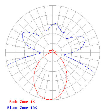 | |||||||||||||||||||||
| Azimuth | Ratio | Azimuth | Ratio | Azimuth | Ratio | Azimuth | Ratio | |||||||||||||||
| 5 | 0.062 | 15 | 0.054 | 25 | 0.048 | 35 | 0.049 | |||||||||||||||
| 45 | 0.042 | 55 | 0.057 | 65 | 0.074 | 75 | 0.069 | |||||||||||||||
| 85 | 0.053 | 95 | 0.032 | 105 | 0.030 | 115 | 0.093 | |||||||||||||||
| 125 | 0.198 | 135 | 0.348 | 145 | 0.518 | 155 | 0.693 | |||||||||||||||
| 165 | 0.848 | 175 | 0.960 | 185 | 1.000 | 195 | 0.960 | |||||||||||||||
| 205 | 0.848 | 215 | 0.693 | 225 | 0.518 | 235 | 0.348 | |||||||||||||||
| 245 | 0.198 | 255 | 0.093 | 265 | 0.030 | 275 | 0.032 | |||||||||||||||
| 285 | 0.053 | 295 | 0.069 | 305 | 0.074 | 315 | 0.057 | |||||||||||||||
| 325 | 0.042 | 335 | 0.049 | 345 | 0.048 | 355 | 0.054 | |||||||||||||||
Structure Registration Number 1042692 Structure Type: GTOWER Registered To: American Towers, LLC Structure Address: Twr 2 - 1129 Sawyer Cemetary Rd (#308954) Signal Mountain, TN County Name: Hamilton County ASR Issued: 02/07/2020 Date Built: 04/15/1999 Site Elevation: 605.3 m (1986 ft.) Structure Height: 161.5 m (530 ft.) Height Overall: 176.5 m (579 ft.) Overall Height AMSL: 781.8 m (2565 ft.) FAA Determination: 07/31/2019 FAA Study #: 2019-ASO-11308-OE FAA Circular #: 70/7460-1L Paint & Light FAA Chapters: 4, 8, 12 PRIOR STUDY 2007-ASO-2940-OE 35-12-36.0 N 85-16-42.3 W (NAD 83) 35-12-35.7 N 85-16-42.4 W (Converted to NAD 27) |
Hurst, TX 76054 Phone: 214-770-7770 Corporation | Title: Ceo Date: 08/03/2023 Application Certifier EDGE SPECTRUM, INC. Edge Spectrum, Inc. Hurst, TX 76054 Applicant Susan Hansen B. W. St. Clair 2305 Vida Shaw Rd. New Iberia, LA 70563 Consultant Ari Meltzer Wiley Rein Llp 2050 M Street, Nw Washington, DC 20036 Josh Weiss Ark Multicasting, Inc. Cedar Hill, TX 75106 CEO Caleb Weiss Ark Multicasting, Inc. Cedar Hill, TX 75106 President Randy Weiss Edge Spectrum, Inc. Hurst, TX 76054 CEO | ||||||||||||||||||||
