
FCCInfo.com
A Service of Cavell, Mertz & Associates, Inc.
(855) FCC-INFO
|
|
KION-TV from 02/23/1997 KION-TV from 10/04/1993 |
Virtual Channel 46 |
|
||||||||||||||||||||||||||||
|
|
Repacking Information: No changes Status: Construction Permit Application Accepted: 08/23/2023 KION-TV CP Expires: 08/28/2026 File Number: -0000219776 FCC Website Links: LMS Facility Details This Application Other KION-TV Applications Including Superseded Applications Mailing Address Correspondence for KION-TV Correspondence related to application -0000219776 Service Contour - Open Street Map or USGS Map (41 dBu) Service Contour - KML / Google Earth (41 dBu) Public Inspection Files History Cards for KION-TV Rabbit Ears Info Search for KION-TV Site Location: 36-32-05.0 N 121-37-18.0 W (NAD 83) Site Location: 36-32-05.1 N 121-37-14.2 W (Converted to NAD 27) ERP: 105 kW Polarization: Elliptically polarized HAAT: 780 m (2559 ft.) Electrical Beam Tilt: 1.5 degrees R/C AGL: 61.5 m (202 ft.) R/C AMSL: 1094.8 m (3592 ft.) Site Elevation: 1033.3 m. (3390 ft.) Height Overall*: 68.9 m (226 ft.) (* As Filed In This Application, may differ from ASR Data, Below.) Directional Antenna - Antenna Make/Model: Electronics Research Inc. ATW20H6-ETC4-32H Antenna ID: 1002645 Polarization: Elliptically polarized | ||||||||||||||||||||||||||||||
| Antenna Data for Antenna Id: 1002645 KION-TV DT File: -0000219776 Electronics Research Inc. - ATW20H6-ETC4-32H Service: DT Standard Pattern: Y Pattern and Field Values Include a 310° Clockwise Rotation | 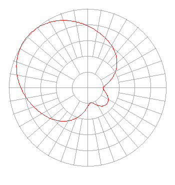 | ||||||||||||||||||||||||||||||
| Azimuth | Ratio | Azimuth | Ratio | Azimuth | Ratio | Azimuth | Ratio | ||||||||||||||||||||||||
| 0 | 0.785 | 10 | 0.723 | 20 | 0.667 | 30 | 0.612 | ||||||||||||||||||||||||
| 40 | 0.554 | 50 | 0.489 | 60 | 0.413 | 70 | 0.328 | ||||||||||||||||||||||||
| 80 | 0.247 | 90 | 0.200 | 100 | 0.214 | 110 | 0.262 | ||||||||||||||||||||||||
| 120 | 0.306 | 130 | 0.322 | 140 | 0.306 | 150 | 0.262 | ||||||||||||||||||||||||
| 160 | 0.214 | 170 | 0.200 | 180 | 0.247 | 190 | 0.328 | ||||||||||||||||||||||||
| 200 | 0.413 | 210 | 0.489 | 220 | 0.554 | 230 | 0.612 | ||||||||||||||||||||||||
| 240 | 0.667 | 250 | 0.723 | 260 | 0.785 | 270 | 0.848 | ||||||||||||||||||||||||
| 280 | 0.907 | 290 | 0.956 | 300 | 0.989 | 310 | 1.000 | ||||||||||||||||||||||||
| 320 | 0.989 | 330 | 0.956 | 340 | 0.907 | 350 | 0.848 | ||||||||||||||||||||||||
Structure Registration Number 1015714 Structure Type: TOWER Registered To: NPG OF MONTEREY-SALINAS CA, LLC Structure Address: Mount Toro Monterey, CA County Name: Monterey County ASR Issued: 04/25/2014 Date Built: 10/01/1968 Site Elevation: 1033.3 m (3390 ft.) Structure Height: 68.9 m (226 ft.) Height Overall: 68.9 m (226 ft.) Overall Height AMSL: 1102.2 m (3616 ft.) FAA Determination: 03/03/1976 FAA Study #: SFO-OE-68-111 Paint & Light FAA Chapters: 1, 3, 11, 21 36-32-05.0 N 121-37-18.0 W (NAD 83) 36-32-05.1 N 121-37-14.2 W (Converted to NAD 27) |
825 Edmond Street Saint Joseph, MO 64501 Phone: 816-271-8652 Limited Liability Company | Title: Evp And Cfo Of Parent, Npgco Date: 08/23/2023 Application Certifier NPG of Monterey-Salinas CA, LLC Npg Of Monterey-salinas Ca, Llc 825 Edmond Street Saint Joseph, MO 64501 Applicant Louis R duTreil, Jr Dutreil Lundin & Rackley Inc P.o. Box 161 Osprey, FL 34229 Technical Consultant Patrick Cross Brooks, Pierce Et Al. 150 Fayetteville Street Suite 1700 Raleigh, NC 27601 | |||||||||||||||||||||||||||||
| |||||||||||||||||||||||||||||||