
FCCInfo.com
A Service of Cavell, Mertz & Associates, Inc.
(855) FCC-INFO
|
|
KFDY-LD from 09/19/2011 KFDY-LD from 11/25/2002 KFDY-LD from 11/09/1992 |
|
|
||||||||||||||||
|
|
Status: Construction Permit Application Accepted: 09/15/2023 KFDY-LD CP Expires: 09/29/2026 File Number: -0000221057 FCC Website Links: LMS Facility Details This Application Other KFDY-LD Applications Including Superseded Applications Mailing Address Correspondence for KFDY-LD Correspondence related to application -0000221057 Service Contour - Open Street Map or USGS Map (51 dBu) Service Contour - KML / Google Earth (51 dBu) Rabbit Ears Info Search for KFDY-LD Site Location: 40-43-39.7 N 96-36-50.9 W (NAD 83) Site Location: 40-43-39.7 N 96-36-49.8 W (Converted to NAD 27) ERP: 15 kW Polarization: Elliptically polarized Electrical Beam Tilt: 0.5 degrees R/C AGL: 140.8 m (462 ft.) R/C AMSL: 566.9 m (1860 ft.) Emission Mask: Full Service Site Elevation: 426.1 m. (1398 ft.) Height Overall*: 194.8 m (639 ft.) (* As Filed In This Application, may differ from ASR Data, Below.) Directional Antenna - Antenna Make/Model: ATC ATC-BCE28M-V3-34 Antenna ID: 1011095 Polarization: Elliptically polarized | ||||||||||||||||||
| Antenna Data for Antenna Id: 1011095 KFDY-LD LD File: -0000221057 ATC - ATC-BCE28M-V3-34 Service: LD Standard Pattern: N Pattern and Field Values Include a 325° Clockwise Rotation | 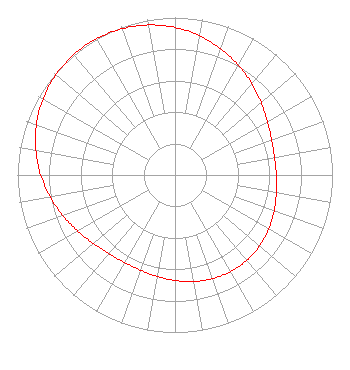 | ||||||||||||||||||
| Azimuth | Ratio | Azimuth | Ratio | Azimuth | Ratio | Azimuth | Ratio | ||||||||||||
| 5 | 0.918 | 15 | 0.876 | 25 | 0.829 | 35 | 0.781 | ||||||||||||
| 45 | 0.734 | 55 | 0.694 | 65 | 0.663 | 75 | 0.645 | ||||||||||||
| 85 | 0.641 | 95 | 0.647 | 105 | 0.661 | 115 | 0.679 | ||||||||||||
| 125 | 0.694 | 135 | 0.705 | 145 | 0.709 | 155 | 0.705 | ||||||||||||
| 165 | 0.694 | 175 | 0.678 | 185 | 0.661 | 195 | 0.647 | ||||||||||||
| 205 | 0.641 | 215 | 0.645 | 225 | 0.663 | 235 | 0.694 | ||||||||||||
| 245 | 0.734 | 255 | 0.781 | 265 | 0.829 | 275 | 0.876 | ||||||||||||
| 285 | 0.918 | 295 | 0.953 | 305 | 0.979 | 315 | 0.995 | ||||||||||||
| 325 | 1.000 | 335 | 0.995 | 345 | 0.979 | 355 | 0.953 | ||||||||||||
Structure Registration Number 1219481 Structure Type: GTOWER Registered To: Warner LLC Structure Address: 7900 Yankee Hill Road Lincoln, NE County Name: Lancaster County ASR Issued: 01/10/2020 Date Built: 01/24/2001 Site Elevation: 426.1 m (1398 ft.) Structure Height: 194.8 m (639 ft.) Height Overall: 194.8 m (639 ft.) Overall Height AMSL: 620.9 m (2037 ft.) FAA Determination: 10/24/2000 FAA Study #: 00-ACE-0930-OE FAA Circular #: 70/7460-1K Paint & Light FAA Chapters: 3, 4, 5, 12 PRIOR FAA 00-ACE-0381-OE 40-43-39.7 N 96-36-50.9 W (NAD 83) 40-43-39.7 N 96-36-49.8 W (Converted to NAD 27) |
214 N. 17th Street Suite 1 Norfolk, NE 68702 Phone: 420-371-0100 Limited Liability Company | Title: Member Date: 09/15/2023 Application Certifier FLOOD COMMUNICATIONS OF OMAHA, LLC Flood Communications Of Omaha, Llc 214 N. 17th Street Suite 1 Norfolk, NE 68702 Applicant Clarence M Beverage Communications Technologies 23 Binsted Drive Medford, NJ 08055-9561 Seth L Williams Fletcher, Heald & Hildreth, Plc 1300 N 17th Street, Suite 1100 Arlington, VA 22209 | |||||||||||||||||