
FCCInfo.com
A Service of Cavell, Mertz & Associates, Inc.
(855) FCC-INFO
|
|
KQCK from 05/31/2005 KQCK from 03/20/1987 KQCK from 08/14/1985 |
Virtual Channel 33 |  |
|
|||||||||||||||
|
|
Repacking Information: No changes Status: License Application Accepted: 08/24/2023 License Expires: 10/01/2030 File Number: -0000219846 FCC Website Links: LMS Facility Details This Application Other KQCK Applications Including Superseded Applications Mailing Address Correspondence for KQCK Correspondence related to application -0000219846 Service Contour - Open Street Map or USGS Map (36 dBu) Service Contour - KML / Google Earth (36 dBu) Public Inspection Files Rabbit Ears Info Search for KQCK Site Location: 40-32-46.5 N 105-11-51.9 W (NAD 83) Site Location: 40-32-46.6 N 105-11-50.0 W (Converted to NAD 27) ERP: 31.1 kW Polarization: Horizontally polarized HAAT: 403 m (1322 ft.) Electrical Beam Tilt: 0.75 degrees R/C AGL: 19.8 m (65 ft.) R/C AMSL: 2197.3 m (7209 ft.) Site Elevation: 2177.5 m. (7144 ft.) Height Overall*: 29.9 m (98 ft.) (* As Filed In This Application, may differ from ASR Data, Below.) Directional Antenna - Antenna Make/Model: Dielectric TLS-V4M-R Antenna ID: 1011030 Polarization: Horizontally polarized | ||||||||||||||||||
| Antenna Data for Antenna Id: 1011030 KQCK DT File: -0000219846 Dielectric - TLS-V4M-R Service: DT Standard Pattern: N | 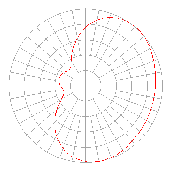 | ||||||||||||||||||
| Azimuth | Ratio | Azimuth | Ratio | Azimuth | Ratio | Azimuth | Ratio | ||||||||||||
| 0 | 0.754 | 10 | 0.864 | 20 | 0.942 | 30 | 0.986 | ||||||||||||
| 40 | 1.000 | 50 | 0.991 | 60 | 0.969 | 70 | 0.944 | ||||||||||||
| 80 | 0.924 | 90 | 0.911 | 100 | 0.905 | 110 | 0.905 | ||||||||||||
| 120 | 0.911 | 130 | 0.924 | 140 | 0.944 | 150 | 0.969 | ||||||||||||
| 160 | 0.991 | 170 | 1.000 | 180 | 0.986 | 190 | 0.942 | ||||||||||||
| 200 | 0.864 | 210 | 0.754 | 220 | 0.622 | 230 | 0.485 | ||||||||||||
| 240 | 0.367 | 250 | 0.300 | 260 | 0.298 | 270 | 0.329 | ||||||||||||
| 280 | 0.353 | 290 | 0.353 | 300 | 0.329 | 310 | 0.298 | ||||||||||||
| 320 | 0.300 | 330 | 0.367 | 340 | 0.485 | 350 | 0.622 | ||||||||||||
Structure Registration Number 1224099 Structure Type: TOWER Registered To: Pinnacle Towers LLC Structure Address: Atop Horsetooth Mtn. Fort Collns, CO County Name: Larimer County ASR Issued: 05/06/2016 Date Built: 08/31/1999 Site Elevation: 2177.5 m (7144 ft.) Structure Height: 24.7 m (81 ft.) Height Overall: 29.9 m (98 ft.) Overall Height AMSL: 2207.4 m (7242 ft.) FAA Determination: 02/25/2002 FAA Study #: 02-ANM-0082-OE Paint & Light FAA Chapters: NONE PRIOR STUDY 01-ANM-0830-OE 40-32-46.5 N 105-11-51.9 W (NAD 83) 40-32-46.6 N 105-11-50.0 W (Converted to NAD 27) |
Clearwater, FL 33758 Phone: 727-535-5622 Not-for-Profit | Title: President Date: 08/24/2023 Application Certifier Christian Television Network Christian Television Corporation, Inc. Clearwater, FL 33758 Applicant Joseph C Chautin, III Hardy, Carey, Chautin & Balkin Llp 1080 W. Causeway Approach Mandeville, LA 70471 | |||||||||||||||||
| |||||||||||||||||||