
FCCInfo.com
A Service of Cavell, Mertz & Associates, Inc.
(855) FCC-INFO
|
|
WXDT-LP from 04/24/1998 WXDT-LP from 07/05/1995 |
|
|
||||||||||||||||
|
|
Status: License Application Accepted: 08/25/2023 License Expires: 02/01/2021 File Number: -0000219931 FCC Website Links: LMS Facility Details This Application Other WXDT-LD Applications Including Superseded Applications Mailing Address Correspondence for WXDT-LD Correspondence related to application -0000219931 Service Contour - Open Street Map or USGS Map (51 dBu) Service Contour - KML / Google Earth (51 dBu) Rabbit Ears Info Search for WXDT-LD Site Location: 26-30-19.6 N 81-51-07.7 W (NAD 83) Site Location: 26-30-18.3 N 81-51-08.4 W (Converted to NAD 27) ERP: 15 kW Polarization: Circularly polarized Electrical Beam Tilt: 0.75 degrees R/C AGL: 93 m (305 ft.) R/C AMSL: 96.1 m (315 ft.) Emission Mask: Stringent Site Elevation: 3.1 m. (10 ft.) Height Overall*: 152.4 m (500 ft.) (* As Filed In This Application, may differ from ASR Data, Below.) Directional Antenna - Antenna Make/Model: Jampro JA/MS-16/D23-36-SCC-BB Antenna ID: 1011035 Polarization: Circularly polarized
| ||||||||||||||||||
| Antenna Data for Antenna Id: 1011035 WXDT-LD LD File: -0000219931 Jampro - JA/MS-16/D23-36-SCC-BB Service: LD Standard Pattern: N Pattern and Field Values Include a 60° Clockwise Rotation | 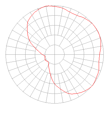 | ||||||||||||||||||
| Azimuth | Ratio | Azimuth | Ratio | Azimuth | Ratio | Azimuth | Ratio | ||||||||||||
| 0 | 0.980 | 10 | 0.960 | 20 | 0.920 | 30 | 0.920 | ||||||||||||
| 40 | 0.960 | 50 | 0.990 | 60 | 1.000 | 70 | 0.990 | ||||||||||||
| 80 | 0.960 | 90 | 0.920 | 100 | 0.920 | 110 | 0.960 | ||||||||||||
| 120 | 0.980 | 130 | 1.000 | 140 | 0.970 | 150 | 0.920 | ||||||||||||
| 160 | 0.850 | 170 | 0.720 | 180 | 0.600 | 190 | 0.440 | ||||||||||||
| 200 | 0.320 | 210 | 0.250 | 220 | 0.200 | 230 | 0.210 | ||||||||||||
| 240 | 0.220 | 250 | 0.210 | 260 | 0.200 | 270 | 0.250 | ||||||||||||
| 280 | 0.320 | 290 | 0.440 | 300 | 0.600 | 310 | 0.720 | ||||||||||||
| 320 | 0.850 | 330 | 0.920 | 340 | 0.970 | 350 | 1.000 | ||||||||||||
Structure Registration Number 1038046 Structure Type: GTOWER Registered To: Southwest Towers, Inc. Structure Address: Twr 3 - 16341 Old Us 41 S Fort Myers, FL County Name: Lee County ASR Issued: 03/05/2021 Date Built: 12/08/2013 Site Elevation: 3.1 m (10 ft.) Structure Height: 152.4 m (500 ft.) Height Overall: 152.4 m (500 ft.) Overall Height AMSL: 155.5 m (510 ft.) FAA Determination: 06/20/2016 FAA Study #: 2016-ASO-12699-OE FAA Circular #: 70/7460-1L Paint & Light FAA Chapters: 3, 4, 5, 12 PRIOR STUDY 2013-ASO-6279-OE 26-30-19.6 N 81-51-07.7 W (NAD 83) 26-30-18.3 N 81-51-08.4 W (Converted to NAD 27) |
5244 Sw Orchid Bay Drive Palm City, FL 34990 Phone: 857-399-3319 Limited Liability Company | Title: Managing Member Date: 08/25/2023 Application Certifier Fort Myers Dtv, Llc 5244 Sw Orchid Bay Drive Palm City, FL 34990 Applicant LAUREN LYNCH FLICK, ESQ Pillsbury Winthrop Shaw Pittman Llp 1200 17th Street Nw Washington, DC 20036 Joseph L Snelson, Jr Meintel, Sgrignoli And Wallace 1282 Smallwood Drive Suite 372 Waldorf, MD 20603 Consultant | |||||||||||||||||