
FCCInfo.com
A Service of Cavell, Mertz & Associates, Inc.
(855) FCC-INFO
|
|
W29ER-D from 09/15/2020 |
|
|
||||||||||||||||
|
|
Status: License Application Accepted: 09/15/2023 License Expires: 08/01/2029 File Number: -0000221056 FCC Website Links: LMS Facility Details This Application Other W26FM-D Applications Including Superseded Applications Mailing Address Correspondence for W26FM-D Correspondence related to application -0000221056 Service Contour - Open Street Map or USGS Map (51 dBu) Service Contour - KML / Google Earth (51 dBu) Rabbit Ears Info Search for W26FM-D Site Location: 37-13-10.3 N 86-18-15.7 W (NAD 83) Site Location: 37-13-10.1 N 86-18-15.8 W (Converted to NAD 27) ERP: 2 kW Polarization: Horizontally polarized R/C AGL: 45 m (148 ft.) R/C AMSL: 272.1 m (893 ft.) Emission Mask: Full Service Site Elevation: 227.1 m. (745 ft.) Height Overall*: 84.1 m (276 ft.) (* As Filed In This Application, may differ from ASR Data, Below.) Directional Antenna - Antenna Make/Model: SAM (4) SAM-460 SBS Antenna ID: 1011094 Polarization: Horizontally polarized | ||||||||||||||||||
| Antenna Data for Antenna Id: 1011094 W26FM-D LD File: -0000221056 SAM - (4) SAM-460 SBS Service: LD Standard Pattern: N Pattern and Field Values Include a 115° Clockwise Rotation | 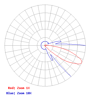 | ||||||||||||||||||
| Azimuth | Ratio | Azimuth | Ratio | Azimuth | Ratio | Azimuth | Ratio | ||||||||||||
| 5 | 0.010 | 15 | 0.010 | 25 | 0.010 | 35 | 0.010 | ||||||||||||
| 45 | 0.010 | 55 | 0.010 | 65 | 0.010 | 75 | 0.040 | ||||||||||||
| 85 | 0.040 | 95 | 0.220 | 105 | 0.700 | 115 | 1.000 | ||||||||||||
| 125 | 0.700 | 135 | 0.220 | 145 | 0.040 | 155 | 0.040 | ||||||||||||
| 165 | 0.010 | 175 | 0.010 | 185 | 0.010 | 195 | 0.010 | ||||||||||||
| 205 | 0.010 | 215 | 0.010 | 225 | 0.010 | 235 | 0.010 | ||||||||||||
| 245 | 0.010 | 255 | 0.010 | 265 | 0.010 | 275 | 0.010 | ||||||||||||
| 285 | 0.010 | 295 | 0.010 | 305 | 0.010 | 315 | 0.010 | ||||||||||||
| 325 | 0.010 | 335 | 0.010 | 345 | 0.010 | 355 | 0.010 | ||||||||||||
Structure Registration Number 1043441 Structure Type: TOWER Registered To: Global Tower, LLC. through American Towers, LLC Structure Address: 166 Grassland-black Gold Road Brownsville, KY County Name: Edmonson County ASR Issued: 08/29/2014 Date Built: 08/04/2009 Site Elevation: 227.1 m (745 ft.) Structure Height: 76.2 m (250 ft.) Height Overall: 84.1 m (276 ft.) Overall Height AMSL: 311.2 m (1021 ft.) FAA Determination: 08/04/2009 FAA Study #: 2009-ASO-3033-OE FAA Circular #: 70/7460-1J Paint & Light FAA Chapters: 4, 6, 13 OM&L to remain the same as prior study = 24-HR MED-STROBES 37-13-10.3 N 86-18-15.7 W (NAD 83) 37-13-10.1 N 86-18-15.8 W (Converted to NAD 27) |
135 N Country Club Drive Hendersonville, TN 37075 Phone: 615-826-0792 Applicant | Title: Partner Date: 09/15/2023 Application Certifier RICHARD C & LISA A GOETZ Richard C & Lisa A Goetz 135 N Country Club Drive Hendersonville, TN 37075 Applicant RICHARD C GOETZ R & L Media Systems 135 N Country Club Dr Hendersonville, TN 37075 BROADCAST CONSULTANT | |||||||||||||||||