
FCCInfo.com
A Service of Cavell, Mertz & Associates, Inc.
(855) FCC-INFO
|
|
|
|
|
||||||||||||||||
|
|
Status: License Application Accepted: 09/27/2023 License Expires: 10/01/2030 File Number: -0000221542 FCC Website Links: LMS Facility Details This Application Other K10PW-D Applications Including Superseded Applications Mailing Address Correspondence for K10PW-D Correspondence related to application -0000221542 Service Contour - Open Street Map or USGS Map (48 dBu) Service Contour - KML / Google Earth (48 dBu) Rabbit Ears Info Search for K10PW-D Site Location: 35-32-08.0 N 108-44-30.0 W (NAD 83) Site Location: 35-32-07.9 N 108-44-27.7 W (Converted to NAD 27) ERP: 1.5 kW Polarization: Horizontally polarized R/C AGL: 37.4 m (123 ft.) R/C AMSL: 2068 m (6785 ft.) Emission Mask: Simple Site Elevation: 2030.6 m. (6662 ft.) Height Overall*: 41.5 m (136 ft.) (* As Filed In This Application, may differ from ASR Data, Below.) Directional Antenna - Antenna Make/Model: Scala DRV-1/2HW Antenna ID: 99965 Polarization: Horizontally polarized
| ||||||||||||||||||
| Antenna Data for Antenna Id: 99965 K10PW-D LD File: -0000221542 Scala - DRV-1/2HW Service: LD Standard Pattern: Y Pattern and Field Values Include a 180.0° Clockwise Rotation | 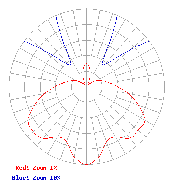 | ||||||||||||||||||
| Azimuth | Ratio | Azimuth | Ratio | Azimuth | Ratio | Azimuth | Ratio | ||||||||||||
| 0 | 0.294 | 10 | 0.239 | 20 | 0.134 | 30 | 0.048 | ||||||||||||
| 40 | 0.037 | 50 | 0.073 | 60 | 0.153 | 70 | 0.220 | ||||||||||||
| 80 | 0.295 | 90 | 0.402 | 100 | 0.554 | 110 | 0.713 | ||||||||||||
| 120 | 0.867 | 130 | 0.869 | 140 | 0.869 | 150 | 0.746 | ||||||||||||
| 160 | 0.756 | 170 | 0.917 | 180 | 1.000 | 190 | 0.917 | ||||||||||||
| 200 | 0.756 | 210 | 0.746 | 220 | 0.869 | 230 | 0.898 | ||||||||||||
| 240 | 0.867 | 250 | 0.713 | 260 | 0.554 | 270 | 0.402 | ||||||||||||
| 280 | 0.295 | 290 | 0.220 | 300 | 0.153 | 310 | 0.073 | ||||||||||||
| 320 | 0.037 | 330 | 0.048 | 340 | 0.134 | 350 | 0.239 | ||||||||||||
Structure Registration Number 1063776 Structure Type: TOWER Registered To: GALLUP, CITY OF Structure Address: Sky City Park Gallup, NM County Name: McKinley County ASR Issued: 04/28/1999 Date Built: 01/15/1964 Site Elevation: 2030.6 m (6662 ft.) Structure Height: 38 m (125 ft.) Height Overall: 41.5 m (136 ft.) Overall Height AMSL: 2072.1 m (6798 ft.) FAA Determination: 11/23/1998 FAA Study #: 98-ASW-4615-OE FAA Circular #: 70/7460-1J Paint & Light FAA Chapters: 3, 4, 5, 13 35-32-08.0 N 108-44-30.0 W (NAD 83) 35-32-07.9 N 108-44-27.7 W (Converted to NAD 27) |
P.o. Box 1800 Raleigh, NC 27602 Phone: 919-839-0300 Corporation | Title: President Date: 09/27/2023 Application Certifier Hearst Properties Inc. Hearst Properties Inc. P.o. Box 1800 Raleigh, NC 27602 Applicant Benjamin Pidek, P.E Ben Pidek Consulting, Llc 7670 Coventry Dr. Temperance, MI 48182 Consulting Engineer Coe W. Ramsey Brooks, Pierce Et Al. 150 Fayetteville Street Suite 1700 Raleigh, NC 27601 | |||||||||||||||||