
FCCInfo.com
A Service of Cavell, Mertz & Associates, Inc.
(855) FCC-INFO
|
|
NEW from 09/13/2022 |
|
|
||||||||||||||||
|
|
Status: License Application Accepted: 09/28/2023 License Expires: 10/01/2030 File Number: -0000221579 FCC Website Links: LMS Facility Details This Application Other KAZF Applications Including Superseded Applications Mailing Address Correspondence for KAZF Correspondence related to application -0000221579 Service Contour - Open Street Map or USGS Map (41 dBu) Service Contour - KML / Google Earth (41 dBu) Public Inspection Files Rabbit Ears Info Search for KAZF Site Location: 34-58-07.6 N 111-30-30.6 W (NAD 83) Site Location: 34-58-07.5 N 111-30-28.1 W (Converted to NAD 27) ERP: 100 kW Polarization: Elliptically polarized HAAT: 433.1 m (1421 ft.) Electrical Beam Tilt: 1.0 degree R/C AGL: 25.6 m (84 ft.) R/C AMSL: 2609.9 m (8563 ft.) Site Elevation: 2584.3 m. (8479 ft.) Height Overall*: 88.1 m (289 ft.) (* As Filed In This Application, may differ from ASR Data, Below.) Directional Antenna - Antenna Make/Model: Dielectric TFU-16DSB-VP-M-R Antenna ID: 1011127 Polarization: Elliptically polarized | ||||||||||||||||||
| Antenna Data for Antenna Id: 1011127 KAZF DT File: -0000221579 Dielectric - TFU-16DSB-VP-M-R Service: DT Standard Pattern: N | 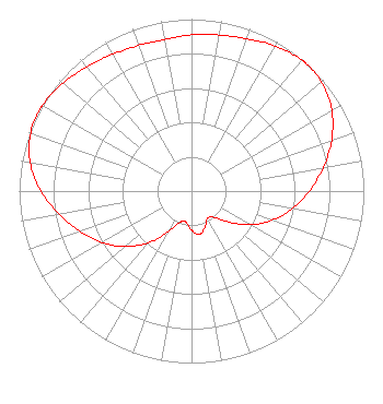 | ||||||||||||||||||
| Azimuth | Ratio | Azimuth | Ratio | Azimuth | Ratio | Azimuth | Ratio | ||||||||||||
| 0 | 0.908 | 10 | 0.921 | 20 | 0.942 | 30 | 0.974 | ||||||||||||
| 40 | 0.995 | 42 | 0.996 | 50 | 0.985 | 60 | 0.940 | ||||||||||||
| 70 | 0.865 | 80 | 0.775 | 90 | 0.684 | 100 | 0.593 | ||||||||||||
| 110 | 0.497 | 120 | 0.392 | 130 | 0.280 | 140 | 0.197 | ||||||||||||
| 150 | 0.184 | 160 | 0.226 | 170 | 0.257 | 180 | 0.227 | ||||||||||||
| 190 | 0.183 | 200 | 0.194 | 210 | 0.278 | 220 | 0.393 | ||||||||||||
| 230 | 0.502 | 240 | 0.599 | 250 | 0.688 | 260 | 0.778 | ||||||||||||
| 270 | 0.873 | 280 | 0.951 | 290 | 0.993 | 297 | 1.000 | ||||||||||||
| 300 | 0.998 | 310 | 0.976 | 320 | 0.944 | 330 | 0.918 | ||||||||||||
| 340 | 0.901 | 350 | 0.895 | ||||||||||||||||
Structure Registration Number 1007647 Structure Type: GTOWER Registered To: Multimedia Holdings Corporation Structure Address: Mormon Mountain Flagstaff, AZ County Name: Coconino County ASR Issued: 08/27/2021 Date Built: 01/01/1970 Site Elevation: 2584.3 m (8479 ft.) Structure Height: 60.9 m (200 ft.) Height Overall: 88.1 m (289 ft.) Overall Height AMSL: 2672.4 m (8768 ft.) FAA Determination: 08/17/2021 FAA Study #: 2021-AWP-11144-OE FAA Circular #: 70/7460-1J Paint & Light FAA Chapters: 3, 4, 5, 13 PRIOR STUDIS 96-AWP-3110-OE / 1999-AWP-748-OE 34-58-07.6 N 111-30-30.6 W (NAD 83) 34-58-07.5 N 111-30-28.1 W (Converted to NAD 27) |
4370 Peachtree Road, Ne Atlanta, GA 30319 Phone: 404-266-3888 Limited Liability Company | Title: Assistant Secretary Date: 09/28/2023 Application Certifier Gray Television Licensee, Llc 4370 Peachtree Road, Ne Atlanta, GA 30319 Applicant Joseph M. Davis, P.E. Chesapeake Rf Consultants, Llc 207 Old Dominion Road Yorktown, VA 23692 Consulting Engineer Joan Stewart Wiley Rein Llp 2050 M Street, Nw Washington, DC 20036 | |||||||||||||||||