
FCCInfo.com
A Service of Cavell, Mertz & Associates, Inc.
(855) FCC-INFO
|
|
|
Virtual Channel 15 |
|
||||||||||||||||
|
|
Status: Construction Permit Application Accepted: 09/28/2023 WSJT-LD CP Expires: 09/29/2026 File Number: -0000214955 FCC Website Links: LMS Facility Details This Application Other WSJT-LD Applications Including Superseded Applications Mailing Address Correspondence for WSJT-LD Correspondence related to application -0000214955 Service Contour - Open Street Map or USGS Map (68 dBu) Service Contour - KML / Google Earth (68 dBu) Public Inspection Files Rabbit Ears Info Search for WSJT-LD Site Location: 39-43-41.0 N 74-50-38.0 W (NAD 83) Site Location: 39-43-40.6 N 74-50-39.4 W (Converted to NAD 27) ERP: 3 kW Polarization: Horizontally polarized Electrical Beam Tilt: .75 degrees R/C AGL: 231 m (758 ft.) R/C AMSL: 265.1 m (870 ft.) Emission Mask: Full Service Site Elevation: 34.1 m. (112 ft.) Height Overall*: 285.7 m (937 ft.) (* As Filed In This Application, may differ from ASR Data, Below.) Directional Antenna - Antenna Make/Model: Propagation System Inc PSIVLP2MC1M-10 Antenna ID: 1005422 Polarization: Horizontally polarized | ||||||||||||||||||
| Antenna Data for Antenna Id: 1005422 WSJT-LD File: -0000214955 Propagation System Inc - PSIVLP2MC1M-10 Service: Standard Pattern: N | 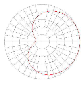 | ||||||||||||||||||
| Azimuth | Ratio | Azimuth | Ratio | Azimuth | Ratio | Azimuth | Ratio | ||||||||||||
| 0 | 0.753 | 10 | 0.815 | 20 | 0.865 | 30 | 0.906 | ||||||||||||
| 40 | 0.940 | 50 | 0.965 | 60 | 0.981 | 70 | 0.992 | ||||||||||||
| 80 | 0.999 | 90 | 1.000 | 100 | 0.999 | 110 | 0.992 | ||||||||||||
| 120 | 0.984 | 130 | 0.976 | 140 | 0.963 | 150 | 0.946 | ||||||||||||
| 160 | 0.924 | 170 | 0.897 | 180 | 0.854 | 190 | 0.803 | ||||||||||||
| 200 | 0.741 | 210 | 0.666 | 220 | 0.575 | 230 | 0.476 | ||||||||||||
| 240 | 0.362 | 250 | 0.266 | 260 | 0.197 | 270 | 0.172 | ||||||||||||
| 280 | 0.162 | 290 | 0.175 | 300 | 0.220 | 310 | 0.300 | ||||||||||||
| 320 | 0.401 | 330 | 0.503 | 340 | 0.596 | 350 | 0.682 | ||||||||||||
Structure Registration Number 1045125 Structure Type: Registered To: NEW JERSEY PUBLIC BROADCASTING AUTHORITY Structure Address: Arrowhead Dr .75 Km N Of Chew Rd Cr 536 Waterford Township, NJ County Name: Camden County ASR Issued: 06/14/2016 Date Built: 01/01/1972 Site Elevation: 34.1 m (112 ft.) Structure Height: 250.5 m (822 ft.) Height Overall: 285.7 m (937 ft.) Overall Height AMSL: 319.8 m (1049 ft.) FAA Determination: 10/23/1984 FAA Study #: 84-AEA-2005-OE FAA Circular #: 70/7460-1F Paint & Light FAA Chapters: 4, 6, 9 12/12/1984 letter from NJ state to FAA confirmed tower is lit per FAA Chapters 4,6,9. 39-43-41.0 N 74-50-38.0 W (NAD 83) 39-43-40.6 N 74-50-39.4 W (Converted to NAD 27) |
P.o. Box 88 Cedar Brook, NJ 08018 Phone: 856-341-4916 Limited Liability Company | Title: Owner Date: 09/28/2023 Application Certifier ENGLE BROADCASTING, LLC Engle Broadcasting, Llc P.o. Box 88 Cedar Brook, NJ 08018 Applicant James Oyster James Oyster Law Firm 108 Oyster Lane Castleton, VA 22716 Paul Engle Engle Broadcasting, Llc Cedar Brook, NJ 08018 General Manager Darryl K DeLawder Delawder Communications, Inc. P.o. Box 1095 Ashburn, VA 20146 | |||||||||||||||||