
FCCInfo.com
A Service of Cavell, Mertz & Associates, Inc.
(855) FCC-INFO
|
|
|
|
|
||||||||||||||||
|
|
Status: STA – Special Temporary Authority Application Accepted: 10/04/2023 STA Expires: 04/01/2024 File Number: -0000222040 FCC Website Links: LMS Facility Details This Application Other W12DI-D Applications Including Superseded Applications Mailing Address Correspondence for W12DI-D Correspondence related to application -0000222040 Service Contour - Open Street Map or USGS Map (48 dBu) Service Contour - KML / Google Earth (48 dBu) Rabbit Ears Info Search for W12DI-D Site Location: 24-33-19.8 N 81-48-04.5 W (NAD 83) Site Location: 24-33-18.3 N 81-48-05.2 W (Converted to NAD 27) ERP: 0.3 kW R/C AGL: 52.5 m (172 ft.) R/C AMSL: 55.9 m (183 ft.) Emission Mask: Simple Site Elevation: 3.4 m. (11 ft.) Height Overall*: 61 m (200 ft.) (* As Filed In This Application, may differ from ASR Data, Below.) Directional Antenna - Antenna Make/Model: Kathrein K523058 Antenna ID: 117291
| ||||||||||||||||||
| Antenna Data for Antenna Id: 117291 W12DI-D LD File: -0000222040 Kathrein - K523058 Service: LD Standard Pattern: Y Pattern and Field Values Include a 60° Clockwise Rotation | 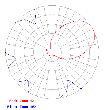 | ||||||||||||||||||
| Azimuth | Ratio | Azimuth | Ratio | Azimuth | Ratio | Azimuth | Ratio | ||||||||||||
| 0 | 0.290 | 10 | 0.420 | 20 | 0.570 | 30 | 0.710 | ||||||||||||
| 40 | 0.870 | 50 | 0.970 | 60 | 1.000 | 70 | 0.970 | ||||||||||||
| 80 | 0.870 | 90 | 0.710 | 100 | 0.570 | 110 | 0.420 | ||||||||||||
| 120 | 0.290 | 130 | 0.190 | 140 | 0.110 | 150 | 0.070 | ||||||||||||
| 160 | 0.090 | 170 | 0.100 | 180 | 0.120 | 190 | 0.130 | ||||||||||||
| 200 | 0.110 | 210 | 0.100 | 220 | 0.080 | 230 | 0.100 | ||||||||||||
| 240 | 0.120 | 250 | 0.100 | 260 | 0.080 | 270 | 0.100 | ||||||||||||
| 280 | 0.110 | 290 | 0.130 | 300 | 0.120 | 310 | 0.100 | ||||||||||||
| 320 | 0.090 | 330 | 0.070 | 340 | 0.110 | 350 | 0.190 | ||||||||||||
Structure Registration Number 1030880 Structure Type: POLE Registered To: ADOLPHUS WARFIELD INC Structure Address: 527 Southard St Key West, FL County Name: Monroe County ASR Issued: 07/11/2003 Date Built: 02/25/2004 Site Elevation: 3.4 m (11 ft.) Structure Height: 61 m (200 ft.) Height Overall: 61 m (200 ft.) Overall Height AMSL: 64.4 m (211 ft.) FAA Determination: 06/20/2003 FAA Study #: 2003-ASO-2664-OE Paint & Light FAA Chapters: NONE Removed expiration date from determination. Scenario 1./jjs/case#635066 24-33-19.8 N 81-48-04.5 W (NAD 83) 24-33-18.3 N 81-48-05.2 W (Converted to NAD 27) |
1845 Empire Avenue Burbank, CA 91504 Phone: 818-729-5300 Limited Liability Company | Title: Chief Operating Officer Date: 10/04/2023 Application Certifier Estrella Television License Llc 1845 Empire Avenue Burbank, CA 91504 Applicant Kathleen Kirby Wiley Rein Llp 2050 M Street, Nw Washington, DC 20036 | |||||||||||||||||