
FCCInfo.com
A Service of Cavell, Mertz & Associates, Inc.
(855) FCC-INFO
|
|
KVCW from 08/26/1987 |
Virtual Channel 33 |  |
|
||||||||||||||||||
|
|
Repacking Information: No changes Status: License Application Accepted: 10/17/2023 License Expires: 10/01/2022 File Number: -0000223227 FCC Website Links: LMS Facility Details This Application Other KVCW Applications Including Superseded Applications Mailing Address Correspondence for KVCW Correspondence related to application -0000223227 Service Contour - Open Street Map or USGS Map (41 dBu) Service Contour - KML / Google Earth (41 dBu) Public Inspection Files Rabbit Ears Info Search for KVCW Site Location: 36-00-27.3 N 115-00-26.9 W (NAD 83) Site Location: 36-00-27.4 N 115-00-23.9 W (Converted to NAD 27) ERP: 57.14 kW Polarization: Elliptically polarized HAAT: 369.5 m (1212 ft.) Electrical Beam Tilt: 1.05 degrees R/C AGL: 47.2 m (155 ft.) R/C AMSL: 1065.5 m (3496 ft.) Site Elevation: 1018.3 m. (3341 ft.) Height Overall*: 67.4 m (221 ft.) (* As Filed In This Application, may differ from ASR Data, Below.) Directional Antenna - Antenna Make/Model: Dielectric TFU-8WB/VP-R S230 Antenna ID: 1011187 Polarization: Elliptically polarized | |||||||||||||||||||||
| Antenna Data for Antenna Id: 1011187 KVCW DX File: -0000223227 Dielectric - TFU-8WB/VP-R S230 Service: DX Standard Pattern: N | 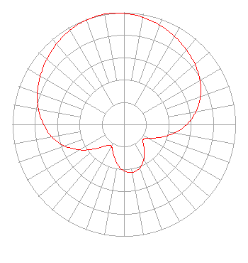 | |||||||||||||||||||||
| Azimuth | Ratio | Azimuth | Ratio | Azimuth | Ratio | Azimuth | Ratio | |||||||||||||||
| 0 | 0.992 | 10 | 0.972 | 20 | 0.942 | 30 | 0.907 | |||||||||||||||
| 40 | 0.870 | 50 | 0.831 | 60 | 0.786 | 70 | 0.729 | |||||||||||||||
| 80 | 0.656 | 90 | 0.564 | 100 | 0.456 | 110 | 0.342 | |||||||||||||||
| 120 | 0.246 | 130 | 0.221 | 140 | 0.278 | 150 | 0.356 | |||||||||||||||
| 160 | 0.414 | 170 | 0.435 | 180 | 0.415 | 190 | 0.357 | |||||||||||||||
| 200 | 0.280 | 210 | 0.225 | 220 | 0.249 | 230 | 0.342 | |||||||||||||||
| 240 | 0.455 | 250 | 0.563 | 260 | 0.655 | 270 | 0.722 | |||||||||||||||
| 280 | 0.780 | 290 | 0.826 | 300 | 0.866 | 310 | 0.903 | |||||||||||||||
| 320 | 0.939 | 330 | 0.970 | 340 | 0.991 | 350 | 1.000 | |||||||||||||||
Structure Registration Number 1203429 Structure Type: LTOWER Registered To: American Towers LLC Structure Address: Black Mountain Road, 1 1/2 Miles West Of Henderson (black Mtn 11 #7501) Henderson, NV County Name: Clark County ASR Issued: 05/22/2017 Date Built: 09/29/2002 Site Elevation: 1018.3 m (3341 ft.) Structure Height: 53 m (174 ft.) Height Overall: 67.4 m (221 ft.) Overall Height AMSL: 1085.7 m (3562 ft.) FAA Determination: 11/03/2004 FAA Study #: 2004-AWP-5214-OE FAA Circular #: 70/7460-1K Paint & Light FAA Chapters: 4, 6, 12 OM&L to remain the same as prior study = 24-HR MED-STROBES 36-00-27.3 N 115-00-26.9 W (NAD 83) 36-00-27.4 N 115-00-23.9 W (Converted to NAD 27) |
1200 Seventeenth Street Nw Washington, DC 20036 Phone: 202-663-8195 Limited Liability Company | Title: Cfo Date: 10/17/2023 Application Certifier Kupn Licensee, Llc 1200 Seventeenth Street Nw Washington, DC 20036 Applicant John E. Hidle, PE Carl T. Jones Corporation 7901 Yarnwood Court Springfield, VA 22153-2827 Consulting Engineer Paul A. Cicelski, Esq Lerman Senter, Pllc 2001 L. Street Nw Suite 400 Washington, DC 20036 Legal Representative | ||||||||||||||||||||
| ||||||||||||||||||||||
