
FCCInfo.com
A Service of Cavell, Mertz & Associates, Inc.
(855) FCC-INFO
|
|
K35FL-D from 03/21/2002 K35FL-D from 03/28/2001 K35FL-D from 05/03/1999 |
|
|
|||||||||||||||||
|
|
Status: License Application Accepted: 11/30/2023 License Expires: 10/01/2022 File Number: -0000229460 FCC Website Links: LMS Facility Details This Application Other K35FL-D Applications Including Superseded Applications Mailing Address Correspondence for K35FL-D Correspondence related to application -0000229460 Service Contour - Open Street Map or USGS Map (51 dBu) Service Contour - KML / Google Earth (51 dBu) Rabbit Ears Info Search for K35FL-D Site Location: 39-29-04.6 N 119-18-10.6 W (NAD 83) Site Location: 39-29-04.9 N 119-18-07.0 W (Converted to NAD 27) ERP: 0.6 kW Polarization: Horizontally polarized R/C AGL: 5.6 m (18 ft.) R/C AMSL: 2095 m (6873 ft.) Emission Mask: Simple Site Elevation: 2089.4 m. (6855 ft.) Height Overall*: 42.7 m (140 ft.) (* As Filed In This Application, may differ from ASR Data, Below.) Directional Antenna - Antenna Make/Model: Antenna Concepts Inc. ACS8E Antenna ID: 17797 Polarization: Horizontally polarized
| |||||||||||||||||||
| Antenna Data for Antenna Id: 17797 K35FL-D LD File: -0000229460 Antenna Concepts Inc. - ACS8E Service: LD Standard Pattern: Y Pattern and Field Values Include a 105° Clockwise Rotation | 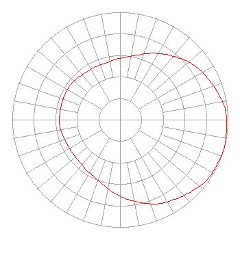 | |||||||||||||||||||
| Azimuth | Ratio | Azimuth | Ratio | Azimuth | Ratio | Azimuth | Ratio | |||||||||||||
| 5 | 0.580 | 15 | 0.620 | 25 | 0.680 | 35 | 0.740 | |||||||||||||
| 45 | 0.800 | 55 | 0.860 | 65 | 0.900 | 75 | 0.940 | |||||||||||||
| 85 | 0.980 | 95 | 0.990 | 105 | 1.000 | 115 | 0.990 | |||||||||||||
| 125 | 0.980 | 135 | 0.940 | 145 | 0.900 | 155 | 0.860 | |||||||||||||
| 165 | 0.800 | 175 | 0.740 | 185 | 0.680 | 195 | 0.620 | |||||||||||||
| 205 | 0.580 | 215 | 0.560 | 225 | 0.540 | 235 | 0.540 | |||||||||||||
| 245 | 0.540 | 255 | 0.550 | 265 | 0.560 | 275 | 0.560 | |||||||||||||
| 285 | 0.560 | 295 | 0.560 | 305 | 0.560 | 315 | 0.550 | |||||||||||||
| 325 | 0.540 | 335 | 0.540 | 345 | 0.540 | 355 | 0.560 | |||||||||||||
Structure Registration Number 1202566 Structure Type: TOWER Registered To: Global Tower, LLC. through American Towers, LLC Structure Address: Eagle Ridge/ Tapaloosa Mining District Silver Spring, NV County Name: Lyon County ASR Issued: 09/02/2014 Date Built: 09/30/1999 Site Elevation: 2089.4 m (6855 ft.) Structure Height: 42.7 m (140 ft.) Height Overall: 42.7 m (140 ft.) Overall Height AMSL: 2132.1 m (6995 ft.) FAA Determination: 09/07/1999 FAA Study #: 99-AWP-1529-OE Paint & Light FAA Chapters: NONE 39-29-04.6 N 119-18-10.6 W (NAD 83) 39-29-04.9 N 119-18-07.0 W (Converted to NAD 27) |
Avon, CO 81620 Phone: 970-628-9881 Applicant | Title: President Of Licensee's Sole Member Date: 11/30/2023 Application Certifier Deerfield Media (Reno) Licensee, LLC Deerfield Media (reno) Licensee, Llc Avon, CO 81620 Applicant Scott R. Flick, Esq Pillsbury Winthrop Shaw Pittman Llp 1200 Seventeenth Street, Nw Washington, DC 20036 | ||||||||||||||||||
