
FCCInfo.com
A Service of Cavell, Mertz & Associates, Inc.
(855) FCC-INFO
|
|
W29FF-D from 04/26/2010 W29FF-D from 05/17/2007 W29FF-D from 11/25/2002 W29FF-D from 02/01/1999 W29FF-D from 06/23/1998 W29FF-D from 09/05/1990 |
|
|
|||||||||||||||||
|
|
Status: License Application Accepted: 11/16/2023 License Expires: 06/01/2031 File Number: -0000226586 FCC Website Links: LMS Facility Details This Application Other W29FF-D Applications Including Superseded Applications Mailing Address Correspondence for W29FF-D Correspondence related to application -0000226586 Service Contour - Open Street Map or USGS Map (51 dBu) Service Contour - KML / Google Earth (51 dBu) Rabbit Ears Info Search for W29FF-D Site Location: 40-06-23.0 N 74-28-49.9 W (NAD 83) Site Location: 40-06-22.6 N 74-28-51.4 W (Converted to NAD 27) ERP: 15 kW Polarization: Horizontally polarized R/C AGL: 77.8 m (255 ft.) R/C AMSL: 140 m (459 ft.) Emission Mask: Full Service Site Elevation: 62.2 m. (204 ft.) Height Overall*: 85 m (279 ft.) (* As Filed In This Application, may differ from ASR Data, Below.) Directional Antenna - Antenna Make/Model: Scala PR-450U Antenna ID: 23501 Polarization: Horizontally polarized
| |||||||||||||||||||
| Antenna Data for Antenna Id: 23501 W29FF-D LD File: -0000226586 Scala - PR-450U Service: LD Standard Pattern: Y Pattern and Field Values Include a 20° Clockwise Rotation | 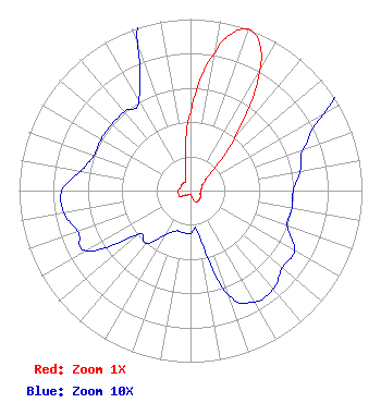 | |||||||||||||||||||
| Azimuth | Ratio | Azimuth | Ratio | Azimuth | Ratio | Azimuth | Ratio | |||||||||||||
| 0 | 0.460 | 10 | 0.815 | 15 | 0.950 | 20 | 1.000 | |||||||||||||
| 25 | 0.950 | 30 | 0.800 | 40 | 0.400 | 50 | 0.150 | |||||||||||||
| 60 | 0.090 | 70 | 0.070 | 80 | 0.065 | 90 | 0.060 | |||||||||||||
| 100 | 0.060 | 110 | 0.060 | 120 | 0.070 | 130 | 0.070 | |||||||||||||
| 140 | 0.075 | 150 | 0.075 | 160 | 0.065 | 170 | 0.025 | |||||||||||||
| 180 | 0.025 | 190 | 0.025 | 200 | 0.025 | 210 | 0.030 | |||||||||||||
| 220 | 0.040 | 230 | 0.040 | 240 | 0.070 | 250 | 0.070 | |||||||||||||
| 260 | 0.075 | 270 | 0.075 | 280 | 0.065 | 290 | 0.060 | |||||||||||||
| 300 | 0.060 | 310 | 0.060 | 320 | 0.060 | 330 | 0.060 | |||||||||||||
| 340 | 0.090 | 350 | 0.180 | |||||||||||||||||
Structure Registration Number 1052983 Structure Type: LTOWER Registered To: American Towers LLC Structure Address: 8 Evergreen Road (088096) Cream Ridge, NJ County Name: Ocean County ASR Issued: 02/01/2013 Date Built: 12/08/1952 Site Elevation: 62.2 m (204 ft.) Structure Height: 77.1 m (253 ft.) Height Overall: 85 m (279 ft.) Overall Height AMSL: 147.2 m (483 ft.) FAA Determination: 01/31/2013 FAA Study #: 2012-AEA-5955-OE FAA Circular #: 70/7460-1K Paint & Light FAA Chapters: 4, 8, 12 OM&L to remain the same as prior study = A MED-DUAL SYSTEM 40-06-23.0 N 74-28-49.9 W (NAD 83) 40-06-22.6 N 74-28-51.4 W (Converted to NAD 27) |
3901 Highway 121 Bedford, TX 76021 Phone: 817-799-2138 Not-for-Profit | Title: Manager Date: 11/16/2023 Application Certifier Word Of God Fellowship, Inc 3901 Highway 121 Bedford, TX 76021 Applicant RICHARD C GOETZ R & L Media Systems 135 N Country Club Dr Hendersonville, TN 37075 BROADCAST CONSULTANT Ari Meltzer, Esq Wiley Rein Llp 1776 K Street, N.w. Washington, DC 20006 | ||||||||||||||||||