
FCCInfo.com
A Service of Cavell, Mertz & Associates, Inc.
(855) FCC-INFO
|
|
KVCW from 08/26/1987 |
Virtual Channel 33 |  |
|
||||||||||||||||||
|
|
Repacking Information: No changes Status: License Application Accepted: 12/20/2023 License Expires: 10/01/2022 File Number: -0000233501 FCC Website Links: LMS Facility Details This Application Other KVCW Applications Including Superseded Applications Mailing Address Correspondence for KVCW Correspondence related to application -0000233501 Service Contour - Open Street Map or USGS Map (41 dBu) Service Contour - KML / Google Earth (41 dBu) Public Inspection Files Rabbit Ears Info Search for KVCW DTS Site Number: 1 Site Location: 36-00-27.3 N 115-00-26.9 W (NAD 83) Site Location: 36-00-27.4 N 115-00-23.9 W (Converted to NAD 27) ERP: 1000 kW Polarization: Horizontally polarized HAAT: 382.9 m (1256 ft.) Electrical Beam Tilt: 0.8 degrees R/C AGL: 60.6 m (199 ft.) R/C AMSL: 1078.9 m (3540 ft.) Site Elevation: 1018.3 m. (3341 ft.) Height Overall*: 67.4 m (221 ft.) (* As Filed In This Application, may differ from ASR Data, Below.) Directional Antenna - Antenna Make/Model: DIELECTRIC TUA-C4-12/48-1-R-T Antenna ID: 73223 Polarization: Horizontally polarized | |||||||||||||||||||||
| Antenna Data for Antenna Id: 73223 KVCW DD File: -0000233501 DIELECTRIC - TUA-C4-12/48-1-R-T Service: DD Standard Pattern: Y | 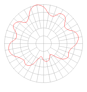 | |||||||||||||||||||||
| Azimuth | Ratio | Azimuth | Ratio | Azimuth | Ratio | Azimuth | Ratio | |||||||||||||||
| 0 | 0.935 | 10 | 0.773 | 20 | 0.743 | 30 | 0.882 | |||||||||||||||
| 40 | 0.862 | 50 | 0.701 | 60 | 0.712 | 70 | 0.858 | |||||||||||||||
| 80 | 0.904 | 90 | 0.844 | 100 | 0.724 | 110 | 0.683 | |||||||||||||||
| 120 | 0.716 | 130 | 0.614 | 140 | 0.398 | 150 | 0.335 | |||||||||||||||
| 160 | 0.428 | 170 | 0.463 | 180 | 0.424 | 190 | 0.340 | |||||||||||||||
| 200 | 0.431 | 210 | 0.637 | 220 | 0.702 | 230 | 0.658 | |||||||||||||||
| 240 | 0.719 | 250 | 0.847 | 260 | 0.900 | 270 | 0.855 | |||||||||||||||
| 280 | 0.719 | 290 | 0.738 | 300 | 0.890 | 310 | 0.858 | |||||||||||||||
| 320 | 0.704 | 330 | 0.760 | 340 | 0.939 | 350 | 1.000 | |||||||||||||||
Structure Registration Number 1203429 Structure Type: LTOWER Registered To: American Towers LLC Structure Address: Black Mountain Road, 1 1/2 Miles West Of Henderson (black Mtn 11 #7501) Henderson, NV County Name: Clark County ASR Issued: 05/22/2017 Date Built: 09/29/2002 Site Elevation: 1018.3 m (3341 ft.) Structure Height: 53 m (174 ft.) Height Overall: 67.4 m (221 ft.) Overall Height AMSL: 1085.7 m (3562 ft.) FAA Determination: 11/03/2004 FAA Study #: 2004-AWP-5214-OE FAA Circular #: 70/7460-1K Paint & Light FAA Chapters: 4, 6, 12 OM&L to remain the same as prior study = 24-HR MED-STROBES 36-00-27.3 N 115-00-26.9 W (NAD 83) 36-00-27.4 N 115-00-23.9 W (Converted to NAD 27) |
1200 Seventeenth Street Nw Washington, DC 20036 Phone: 202-663-8195 Limited Liability Company | Title: Evp And Cfo, Sinclair, Inc Date: 12/20/2023 Application Certifier Kupn Licensee, Llc 1200 Seventeenth Street Nw Washington, DC 20036 Applicant Kevin Fisher Smith And Fisher, Llc 4791 Wintergreen Court Woodbridge, VA 22192 Miles S Mason Pillsbury Winthrop Shaw Pittman Llp 1200 Seventeenth Street Nw Washington, DC 20036 | ||||||||||||||||||||
| ||||||||||||||||||||||
