
FCCInfo.com
A Service of Cavell, Mertz & Associates, Inc.
(855) FCC-INFO
|
|
KASW from 07/01/1994 |
Post-repack Channel 27 Virtual Channel 61 |  |
|
|||||||||||||||||||||||||
|
|
Repacking Information: Pre-Repack Channel: 49 Post-Repack Channel: 27 Post-Repack ERP: 345 kW Phase: 1 Completion Deadline: 11/30/2018 Find nearby TV Facilities Status: License Application Accepted: 12/20/2023 License Expires: 10/01/2030 File Number: -0000233477 FCC Website Links: LMS Facility Details This Application Other KASW Applications Including Superseded Applications Mailing Address Correspondence for KASW Correspondence related to application -0000233477 Service Contour - Open Street Map or USGS Map (41 dBu) Service Contour - KML / Google Earth (41 dBu) Public Inspection Files Rabbit Ears Info Search for KASW DTS Site Number: 1 Site Location: 33-20-01.0 N 112-03-47.0 W (NAD 83) Site Location: 33-20-00.8 N 112-03-44.5 W (Converted to NAD 27) ERP: 445 kW Polarization: Elliptically polarized HAAT: 550.9 m (1807 ft.) Electrical Beam Tilt: 0.95 degrees R/C AGL: 98.5 m (323 ft.) R/C AMSL: 908.5 m (2981 ft.) Emission Mask: Simple Site Elevation: 810 m. (2657 ft.) Height Overall*: 105 m (344 ft.) (* As Filed In This Application, may differ from ASR Data, Below.) Directional Antenna - Antenna Make/Model: Dielectric TFU-17ETT/VP-R 4C190 Antenna ID: 1004589 Polarization: Elliptically polarized
| ||||||||||||||||||||||||||||
| Antenna Data for Antenna Id: 1004589 KASW DD File: -0000233477 Dielectric - TFU-17ETT/VP-R 4C190 Service: DD Standard Pattern: Y | 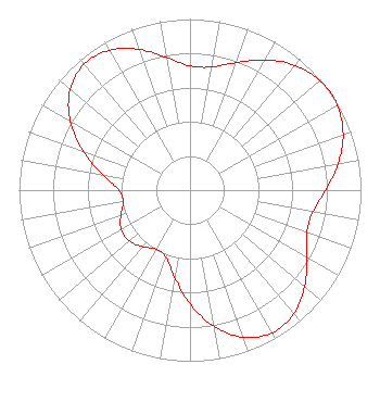 | ||||||||||||||||||||||||||||
| Azimuth | Ratio | Azimuth | Ratio | Azimuth | Ratio | Azimuth | Ratio | ||||||||||||||||||||||
| 0 | 0.727 | 10 | 0.730 | 20 | 0.793 | 30 | 0.879 | ||||||||||||||||||||||
| 40 | 0.953 | 50 | 0.994 | 55 | 1.000 | 60 | 0.994 | ||||||||||||||||||||||
| 70 | 0.953 | 80 | 0.879 | 90 | 0.793 | 100 | 0.730 | ||||||||||||||||||||||
| 110 | 0.727 | 120 | 0.787 | 130 | 0.875 | 140 | 0.944 | ||||||||||||||||||||||
| 150 | 0.962 | 160 | 0.915 | 170 | 0.809 | 180 | 0.663 | ||||||||||||||||||||||
| 190 | 0.516 | 200 | 0.415 | 210 | 0.397 | 220 | 0.431 | ||||||||||||||||||||||
| 230 | 0.463 | 240 | 0.463 | 250 | 0.431 | 260 | 0.397 | ||||||||||||||||||||||
| 270 | 0.415 | 280 | 0.516 | 290 | 0.663 | 300 | 0.809 | ||||||||||||||||||||||
| 310 | 0.915 | 320 | 0.962 | 330 | 0.944 | 340 | 0.875 | ||||||||||||||||||||||
| 350 | 0.787 | ||||||||||||||||||||||||||||
Structure Registration Number 1002069 Structure Type: TOWER Registered To: Scripps Broadcasting Holdings LLC Structure Address: South Mountain Antenna Farm Approx 8 Mi S Phoenix, AZ County Name: Maricopa County ASR Issued: 10/30/2019 Date Built: 09/01/1995 Site Elevation: 810 m (2657 ft.) Structure Height: 90 m (295 ft.) Height Overall: 105 m (344 ft.) Overall Height AMSL: 915 m (3002 ft.) FAA Determination: 09/25/1995 FAA Study #: 95-AWP-0210-OE Paint & Light FAA Chapters: None 33-20-01.0 N 112-03-47.0 W (NAD 83) 33-20-00.8 N 112-03-44.5 W (Converted to NAD 27) |
312 Walnut Street 28th Floor Cincinnati, OH 45202 Phone: 513-977-3000 Limited Liability Company | Title: Vice President Date: 12/20/2023 Application Certifier SCRIPPS BROADCASTING HOLDINGS LLC Scripps Broadcasting Holdings Llc 312 Walnut Street 28th Floor Cincinnati, OH 45202 Applicant Coe W. Ramsey Brooks, Pierce Et Al. 150 Fayetteville Street Suite 1700 Raleigh, NC 27601 | |||||||||||||||||||||||||||
| |||||||||||||||||||||||||||||
