
FCCInfo.com
A Service of Cavell, Mertz & Associates, Inc.
(855) FCC-INFO
|
|
WXSL-LD from 02/22/2011 |
|
|
||||||||||||||||
|
|
Status: License Application Accepted: 12/27/2023 License Expires: 12/01/2029 File Number: -0000234049 FCC Website Links: LMS Facility Details This Application Other WXSL-LD Applications Including Superseded Applications Mailing Address Correspondence for WXSL-LD Correspondence related to application -0000234049 Service Contour - Open Street Map or USGS Map (51 dBu) Service Contour - KML / Google Earth (51 dBu) Rabbit Ears Info Search for WXSL-LD Site Location: 38-54-55.5 N 89-16-29.8 W (NAD 83) Site Location: 38-54-55.3 N 89-16-29.5 W (Converted to NAD 27) ERP: 15 kW Polarization: Horizontally polarized Electrical Beam Tilt: 0.75 degrees R/C AGL: 47.3 m (155 ft.) R/C AMSL: 221 m (725 ft.) Emission Mask: Full Service Site Elevation: 173.7 m. (570 ft.) Height Overall*: 79.6 m (261 ft.) (* As Filed In This Application, may differ from ASR Data, Below.) Directional Antenna - Antenna Make/Model: Kathrein 75010210 Antenna ID: 1010776 Polarization: Horizontally polarized | ||||||||||||||||||
| Antenna Data for Antenna Id: 1010776 WXSL-LD LD File: -0000234049 Kathrein - 75010210 Service: LD Standard Pattern: Y Pattern and Field Values Include a 250° Clockwise Rotation | 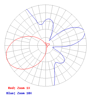 | ||||||||||||||||||
| Azimuth | Ratio | Azimuth | Ratio | Azimuth | Ratio | Azimuth | Ratio | ||||||||||||
| 0 | 0.062 | 10 | 0.065 | 20 | 0.055 | 30 | 0.027 | ||||||||||||
| 40 | 0.017 | 50 | 0.057 | 60 | 0.088 | 70 | 0.101 | ||||||||||||
| 80 | 0.090 | 90 | 0.061 | 100 | 0.022 | 110 | 0.022 | ||||||||||||
| 120 | 0.047 | 130 | 0.060 | 140 | 0.057 | 150 | 0.049 | ||||||||||||
| 160 | 0.064 | 170 | 0.117 | 180 | 0.201 | 190 | 0.312 | ||||||||||||
| 200 | 0.456 | 210 | 0.605 | 220 | 0.754 | 230 | 0.880 | ||||||||||||
| 240 | 0.968 | 250 | 1.000 | 260 | 0.966 | 270 | 0.874 | ||||||||||||
| 280 | 0.749 | 290 | 0.597 | 300 | 0.445 | 310 | 0.312 | ||||||||||||
| 320 | 0.200 | 330 | 0.116 | 340 | 0.062 | 350 | 0.052 | ||||||||||||
Structure Registration Number 1207918 Structure Type: GTOWER Registered To: American Towers, LLC Structure Address: 904 South 7th Street (#303668) Mulberry Grove, IL County Name: Bond County ASR Issued: 07/14/2022 Date Built: 02/12/2000 Site Elevation: 173.7 m (570 ft.) Structure Height: 76.2 m (250 ft.) Height Overall: 79.6 m (261 ft.) Overall Height AMSL: 253.3 m (831 ft.) FAA Determination: 07/07/2022 FAA Study #: 2021-AGL-27903-OE FAA Circular #: 70/7460-1K Paint & Light FAA Chapters: 4, 8, 12 PRIOR STUDY 2011-AGL-8129-OE 38-54-55.5 N 89-16-29.8 W (NAD 83) 38-54-55.3 N 89-16-29.5 W (Converted to NAD 27) |
888c 8th Ave Suite 733 New York, NY 10019 Phone: 212-580-1349 Limited Liability Company | Title: Member Date: 12/27/2023 Application Certifier Sagamorehill Of Kansas City Licenses, Llc 888c 8th Ave Suite 733 New York, NY 10019 Applicant Clarence M Beverage Communications Technologies 23 Binsted Drive Medford, NJ 08055 Broadcast Engineering Consultant Aaron P Shainis Shainis & Peltzman, Chartered 1850 M St. Nw Suite 240 Washington, DC 20036 Legal Counsel | |||||||||||||||||