
FCCInfo.com
A Service of Cavell, Mertz & Associates, Inc.
(855) FCC-INFO
|
|
KCBD from 05/08/1980 |
Virtual Channel 11 |  |
|
|||||||||||||||||||||
|
|
Repacking Information: No changes Status: Application Application Accepted: 01/12/2024 License Expires: 08/01/2022 File Number: -0000235314 FCC Website Links: LMS Facility Details This Application Other KCBD Applications Including Superseded Applications Mailing Address Correspondence for KCBD Correspondence related to application -0000235314 Service Contour - Open Street Map or USGS Map (41 dBu) Service Contour - KML / Google Earth (41 dBu) Public Inspection Files History Cards for KCBD Rabbit Ears Info Search for KCBD Site Location: 33-30-08.3 N 101-52-21.3 W (NAD 83) Site Location: 33-30-08.0 N 101-52-19.7 W (Converted to NAD 27) ERP: 1000 kW Polarization: Horizontally polarized HAAT: 282.1 m (926 ft.) Electrical Beam Tilt: 0.7 degrees R/C AGL: 286.2 m (939 ft.) R/C AMSL: 1263.7 m (4146 ft.) Site Elevation: 977.5 m. (3207 ft.) Height Overall*: 297.2 m (975 ft.) (* As Filed In This Application, may differ from ASR Data, Below.) Directional Antenna - Antenna Make/Model: R.F. Systems PHPR64U3313 Antenna ID: 1005100 Polarization: Horizontally polarized | ||||||||||||||||||||||||
| Antenna Data for Antenna Id: 1005100 KCBD DT File: -0000235314 R.F. Systems - PHPR64U3313 Service: DT Standard Pattern: Y | 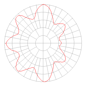 | ||||||||||||||||||||||||
| Azimuth | Ratio | Azimuth | Ratio | Azimuth | Ratio | Azimuth | Ratio | ||||||||||||||||||
| 0 | 0.995 | 1 | 0.998 | 10 | 0.914 | 20 | 0.718 | ||||||||||||||||||
| 30 | 0.569 | 40 | 0.652 | 50 | 0.731 | 60 | 0.630 | ||||||||||||||||||
| 70 | 0.460 | 80 | 0.434 | 90 | 0.476 | 100 | 0.438 | ||||||||||||||||||
| 110 | 0.482 | 120 | 0.652 | 130 | 0.729 | 140 | 0.639 | ||||||||||||||||||
| 150 | 0.573 | 160 | 0.733 | 170 | 0.934 | 177 | 1.000 | ||||||||||||||||||
| 180 | 0.988 | 190 | 0.844 | 200 | 0.682 | 210 | 0.766 | ||||||||||||||||||
| 220 | 0.944 | 225 | 0.964 | 230 | 0.904 | 240 | 0.713 | ||||||||||||||||||
| 250 | 0.698 | 260 | 0.868 | 269 | 0.955 | 270 | 0.950 | ||||||||||||||||||
| 280 | 0.840 | 290 | 0.691 | 300 | 0.732 | 310 | 0.915 | ||||||||||||||||||
| 315 | 0.956 | 320 | 0.924 | 330 | 0.730 | 340 | 0.674 | ||||||||||||||||||
| 350 | 0.872 | ||||||||||||||||||||||||
Structure Registration Number 1248244 Structure Type: GTOWER Registered To: FLP Ramar, Ltd. Structure Address: 100th & University Lubbock, TX County Name: Lubbock County ASR Issued: 10/27/2017 Date Built: 12/08/2006 Site Elevation: 977.5 m (3207 ft.) Structure Height: 295.7 m (970 ft.) Height Overall: 297.2 m (975 ft.) Overall Height AMSL: 1274.7 m (4182 ft.) FAA Determination: 08/02/2017 FAA Study #: 2017-ASW-7973-OE FAA Circular #: 70/7460-1K Paint & Light FAA Chapters: 4, 9, 12 PRIOR STUDY 2007-ASW-3651-OE 33-30-08.3 N 101-52-21.3 W (NAD 83) 33-30-08.0 N 101-52-19.7 W (Converted to NAD 27) |
4370 Peachtree Road, Ne Atlanta, GA 30319 Phone: 404-504-9828 Limited Liability Company | Title: Assistant Secretary Date: 01/12/2024 Application Certifier Gray Television Licensee, Llc 4370 Peachtree Road, Ne Atlanta, GA 30319 Applicant Joseph M. Davis, P.E. Chesapeake Rf Consultants, Llc 207 Old Dominion Road Yorktown, VA 23692 Consulting Engineer David Burke Gray Television Licensee, Llc 201 Monroe Street Montgomery, AL 36104 Senior Vice President and CTO Joan Stewart Wiley Rein Llp 2050 M Street, Nw Washington, DC 20036 | |||||||||||||||||||||||
|
| ||||||||||||||||||||||||