
FCCInfo.com
A Service of Cavell, Mertz & Associates, Inc.
(855) FCC-INFO
|
|
|
Virtual Channel 29 |  |
|
|||||||||||||||
|
|
Repacking Information: No changes Status: Construction Permit Application Accepted: 01/16/2024 KMPX CP Expires: 01/18/2027 File Number: -0000235452 FCC Website Links: LMS Facility Details This Application Other KMPX Applications Including Superseded Applications Mailing Address Correspondence for KMPX Correspondence related to application -0000235452 Service Contour - Open Street Map or USGS Map (41 dBu) Service Contour - KML / Google Earth (41 dBu) Public Inspection Files Rabbit Ears Info Search for KMPX Site Location: 32-35-07.2 N 96-58-42.1 W (NAD 83) Site Location: 32-35-06.7 N 96-58-41.1 W (Converted to NAD 27) ERP: 1000 kW Polarization: Elliptically polarized HAAT: 526.6 m (1728 ft.) Electrical Beam Tilt: 1.0 degree R/C AGL: 472.9 m (1552 ft.) R/C AMSL: 719.2 m (2360 ft.) Site Elevation: 246.3 m. (808 ft.) Height Overall*: 480 m (1575 ft.) (* As Filed In This Application, may differ from ASR Data, Below.) Directional Antenna - Antenna Make/Model: Dielectric TFU-22ETT/VP-R 4C170 Antenna ID: 1011400 Polarization: Elliptically polarized | ||||||||||||||||||
| Antenna Data for Antenna Id: 1011400 KMPX DT File: -0000235452 Dielectric - TFU-22ETT/VP-R 4C170 Service: DT Standard Pattern: N | 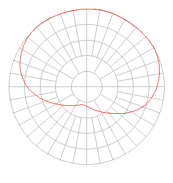 | ||||||||||||||||||
| Azimuth | Ratio | Azimuth | Ratio | Azimuth | Ratio | Azimuth | Ratio | ||||||||||||
| 0 | 0.996 | 10 | 1.000 | 20 | 0.996 | 30 | 0.989 | ||||||||||||
| 40 | 0.990 | 50 | 0.997 | 60 | 0.998 | 70 | 0.983 | ||||||||||||
| 80 | 0.951 | 90 | 0.907 | 100 | 0.847 | 110 | 0.764 | ||||||||||||
| 120 | 0.656 | 130 | 0.542 | 140 | 0.445 | 150 | 0.375 | ||||||||||||
| 160 | 0.323 | 170 | 0.280 | 180 | 0.250 | 190 | 0.239 | ||||||||||||
| 200 | 0.250 | 210 | 0.280 | 220 | 0.323 | 230 | 0.375 | ||||||||||||
| 240 | 0.445 | 250 | 0.542 | 260 | 0.656 | 270 | 0.764 | ||||||||||||
| 280 | 0.847 | 290 | 0.907 | 300 | 0.951 | 310 | 0.983 | ||||||||||||
| 320 | 0.998 | 330 | 0.997 | 340 | 0.990 | 350 | 0.989 | ||||||||||||
Structure Registration Number 1011407 Structure Type: GTOWER Registered To: HILL TOWER CORPORATION Structure Address: 1570 Beltline Rd Cedar Hill, TX County Name: Dallas County ASR Issued: 02/14/2019 Date Built: 04/27/2018 Site Elevation: 246.3 m (808 ft.) Structure Height: 443 m (1453 ft.) Height Overall: 480 m (1575 ft.) Overall Height AMSL: 726.3 m (2383 ft.) FAA Determination: 03/22/2018 FAA Study #: 2018-ASW-2502-OE FAA Circular #: 70/7460-1L Paint & Light FAA Chapters: 4, 9, 12 PRIOR STUDY 1997-ASW-802-OE 32-35-07.2 N 96-58-42.1 W (NAD 83) 32-35-06.7 N 96-58-41.1 W (Converted to NAD 27) |
8350 Broad Street Suite 2000 Tysons, VA 22102 Phone: 703-873-6606 Corporation | Title: Secretary Date: 01/16/2024 Application Certifier Wfaa-tv, Inc. 8350 Broad Street Suite 2000 Tysons, VA 22102 Applicant William T Godfrey, Jr Kessler And Gehman Associates, Inc. Kessler And Gehman Associates, Inc. 507-d Nw 60th Street Gainesville, FL 32607-2055 Consulting Engineers Michael Beder, Esq Tegna Inc. 8350 Broad Street Suite 2000 Tysons, VA 22102 Associate General Counsel | |||||||||||||||||