
FCCInfo.com
A Service of Cavell, Mertz & Associates, Inc.
(855) FCC-INFO
|
|
K42FE-D from 07/09/2013 K42FE-D from 04/24/2002 K42FE-D from 12/02/1991 |
|
|
||||||||||||||||
|
|
Status: License Application Accepted: 01/23/2024 License Expires: 06/01/2021 File Number: -0000236002 FCC Website Links: LMS Facility Details This Application Other K27NA-D Applications Including Superseded Applications Mailing Address Correspondence for K27NA-D Correspondence related to application -0000236002 Service Contour - Open Street Map or USGS Map (51 dBu) Service Contour - KML / Google Earth (51 dBu) Rabbit Ears Info Search for K27NA-D Site Location: 32-28-25.2 N 93-46-13.7 W (NAD 83) Site Location: 32-28-24.6 N 93-46-13.1 W (Converted to NAD 27) ERP: 15 kW Polarization: Elliptically polarized R/C AGL: 116.3 m (382 ft.) R/C AMSL: 189.8 m (623 ft.) Emission Mask: Full Service Site Elevation: 73.5 m. (241 ft.) Height Overall*: 128 m (420 ft.) (* As Filed In This Application, may differ from ASR Data, Below.) Directional Antenna - Antenna Make/Model: DIELECTRIC DLP-8M/VP Antenna ID: 1011418 Polarization: Elliptically polarized | ||||||||||||||||||
| Antenna Data for Antenna Id: 1011418 K27NA-D LD File: -0000236002 DIELECTRIC - DLP-8M/VP Service: LD Standard Pattern: N | 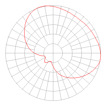 | ||||||||||||||||||
| Azimuth | Ratio | Azimuth | Ratio | Azimuth | Ratio | Azimuth | Ratio | ||||||||||||
| 0 | 0.976 | 10 | 0.944 | 20 | 0.918 | 30 | 0.901 | ||||||||||||
| 40 | 0.895 | 50 | 0.908 | 60 | 0.921 | 70 | 0.942 | ||||||||||||
| 80 | 0.974 | 90 | 0.995 | 100 | 1.000 | 110 | 0.940 | ||||||||||||
| 120 | 0.865 | 130 | 0.775 | 140 | 0.684 | 150 | 0.593 | ||||||||||||
| 160 | 0.497 | 170 | 0.392 | 180 | 0.280 | 190 | 0.197 | ||||||||||||
| 200 | 0.184 | 210 | 0.226 | 220 | 0.257 | 230 | 0.227 | ||||||||||||
| 240 | 0.183 | 250 | 0.194 | 260 | 0.278 | 270 | 0.393 | ||||||||||||
| 280 | 0.502 | 290 | 0.599 | 300 | 0.688 | 310 | 0.778 | ||||||||||||
| 320 | 0.873 | 330 | 0.951 | 340 | 0.993 | 350 | 1.000 | ||||||||||||
Structure Registration Number 1013803 Structure Type: GTOWER Registered To: SBA Towers, LLC Structure Address: 2002 Desoto Street (la01108-a) Shreveport, LA County Name: Caddo Parish ASR Issued: 11/08/2019 Date Built: 04/17/1998 Site Elevation: 73.5 m (241 ft.) Structure Height: 121.9 m (400 ft.) Height Overall: 128 m (420 ft.) Overall Height AMSL: 201.5 m (661 ft.) FAA Determination: 11/05/2019 FAA Study #: 2019-ASW-15187-OE FAA Circular #: 70/7460-1L Paint & Light FAA Chapters: 4, 8, 12 32-28-25.2 N 93-46-13.7 W (NAD 83) 32-28-24.6 N 93-46-13.1 W (Converted to NAD 27) |
Hurst, TX 76054 Phone: 214-770-7770 Corporation | Title: Ceo Date: 01/23/2024 Application Certifier EDGE SPECTRUM, INC. Edge Spectrum, Inc. Hurst, TX 76054 Applicant Susan Hansen B. W. St. Clair 2305 Vida Shaw Rd. New Iberia, LA 70563 Consultant Ari Meltzer Wiley Rein Llp 2050 M Street, Nw Washington, DC 20036 Josh Weiss Ark Multicasting, Inc. Cedar Hill, TX 75106 CEO Caleb Weiss Ark Multicasting, Inc. Cedar Hill, TX 75106 President Randy Weiss Edge Spectrum, Inc. Hurst, TX 76054 CEO | |||||||||||||||||