
FCCInfo.com
A Service of Cavell, Mertz & Associates, Inc.
(855) FCC-INFO
|
|
K25PZ-D from 06/03/2021 K25PZ-D from 07/11/2012 |
|
|
|||||||||||||||||||
|
|
Status: License Application Accepted: 01/24/2024 License Expires: 06/01/2021 File Number: -0000236285 FCC Website Links: LMS Facility Details This Application Other KLGC-LD Applications Including Superseded Applications Mailing Address Correspondence for KLGC-LD Correspondence related to application -0000236285 Service Contour - Open Street Map or USGS Map (51 dBu) Service Contour - KML / Google Earth (51 dBu) Rabbit Ears Info Search for KLGC-LD Site Location: 31-02-16.0 N 92-29-45.0 W (NAD 83) Site Location: 31-02-15.3 N 92-29-44.5 W (Converted to NAD 27) ERP: 15 kW Polarization: Elliptically polarized Electrical Beam Tilt: 1.5 degrees R/C AGL: 426.7 m (1400 ft.) R/C AMSL: 474.8 m (1558 ft.) Emission Mask: Full Service Site Elevation: 48.1 m. (158 ft.) Height Overall*: 474.9 m (1558 ft.) (* As Filed In This Application, may differ from ASR Data, Below.) Directional Antenna - Antenna Make/Model: Electronics Research Inc. ALP12L6-ESW-25 Antenna ID: 1008069 Polarization: Elliptically polarized | |||||||||||||||||||||
| Antenna Data for Antenna Id: 1008069 KLGC-LD LD File: -0000236285 Electronics Research Inc. - ALP12L6-ESW-25 Service: LD Standard Pattern: N Pattern and Field Values Include a 330° Clockwise Rotation | 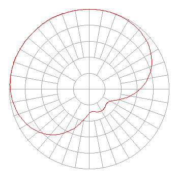 | |||||||||||||||||||||
| Azimuth | Ratio | Azimuth | Ratio | Azimuth | Ratio | Azimuth | Ratio | |||||||||||||||
| 0 | 0.994 | 10 | 0.995 | 20 | 0.991 | 30 | 0.982 | |||||||||||||||
| 40 | 0.964 | 50 | 0.936 | 60 | 0.891 | 70 | 0.830 | |||||||||||||||
| 80 | 0.747 | 90 | 0.640 | 100 | 0.519 | 110 | 0.395 | |||||||||||||||
| 120 | 0.308 | 130 | 0.286 | 140 | 0.306 | 150 | 0.316 | |||||||||||||||
| 160 | 0.306 | 170 | 0.286 | 180 | 0.308 | 190 | 0.395 | |||||||||||||||
| 200 | 0.519 | 210 | 0.640 | 220 | 0.747 | 230 | 0.830 | |||||||||||||||
| 240 | 0.891 | 250 | 0.936 | 260 | 0.964 | 270 | 0.982 | |||||||||||||||
| 280 | 0.991 | 290 | 0.995 | 300 | 0.994 | 310 | 0.994 | |||||||||||||||
| 320 | 0.995 | 330 | 1.000 | 340 | 0.995 | 350 | 0.994 | |||||||||||||||
Structure Registration Number 1020933 Structure Type: TOWER Registered To: Gray Media Group, Inc. Structure Address: 2 Mi E Forest Hill, LA County Name: Rapides Parish ASR Issued: 09/09/2020 Date Built: 09/09/2009 Site Elevation: 48.1 m (158 ft.) Structure Height: 473.7 m (1554 ft.) Height Overall: 474.9 m (1558 ft.) Overall Height AMSL: 523 m (1716 ft.) FAA Determination: 10/26/2009 FAA Study #: 2009-ASW-5225-OE Paint & Light FAA Chapters: 1, 3, 10.1, 19.1, 21 Continue As Is OM&L = PAINT/RED LIGHTS 31-02-16.0 N 92-29-45.0 W (NAD 83) 31-02-15.3 N 92-29-44.5 W (Converted to NAD 27) |
4370 Peachtree Road, Ne Atlanta, GA 30319 Phone: 404-266-5500 Limited Liability Company | Title: Assistant Secretary Date: 01/24/2024 Application Certifier Gray Television Licensee, Llc 4370 Peachtree Road, Ne Atlanta, GA 30319 Applicant Joan Stewart Wiley Rein Llp 2050 M Street, Nw Washington, DC 20036 | ||||||||||||||||||||
| ||||||||||||||||||||||