
FCCInfo.com
A Service of Cavell, Mertz & Associates, Inc.
(855) FCC-INFO
|
|
W32FP-D from 01/28/2021 W32FP-D from 01/21/2020 W32FP-D from 01/17/2020 W32FP-D from 04/22/1997 |
|
|
||||||||||||||||
|
|
Status: Construction Permit Application Accepted: 03/04/2024 WSRG-LD CP Expires: 03/02/2026 File Number: -0000240348 FCC Website Links: LMS Facility Details This Application Other WSRG-LD Applications Including Superseded Applications Mailing Address Correspondence for WSRG-LD Correspondence related to application -0000240348 Service Contour - Open Street Map or USGS Map (51 dBu) Service Contour - KML / Google Earth (51 dBu) Rabbit Ears Info Search for WSRG-LD Site Location: 41-26-09.1 N 75-43-42.3 W (NAD 83) Site Location: 41-26-08.8 N 75-43-43.6 W (Converted to NAD 27) ERP: 15 kW Polarization: Horizontally polarized R/C AGL: 51.8 m (170 ft.) R/C AMSL: 682.4 m (2239 ft.) Emission Mask: Full Service Site Elevation: 630.6 m. (2069 ft.) Height Overall*: 104.5 m (343 ft.) (* As Filed In This Application, may differ from ASR Data, Below.) Directional Antenna - Antenna Make/Model: Propagation System Inc PSILP12OI Antenna ID: 1011533 Polarization: Horizontally polarized | ||||||||||||||||||
| Antenna Data for Antenna Id: 1011533 WSRG-LD LD File: -0000240348 Propagation System Inc - PSILP12OI Service: LD Standard Pattern: N Pattern and Field Values Include a 167.0° Clockwise Rotation | 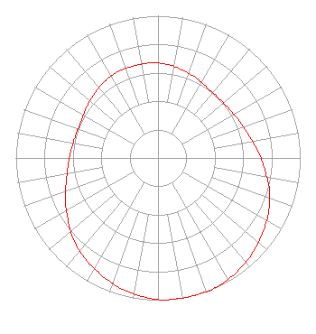 | ||||||||||||||||||
| Azimuth | Ratio | Azimuth | Ratio | Azimuth | Ratio | Azimuth | Ratio | ||||||||||||
| 7 | 0.660 | 17 | 0.640 | 27 | 0.620 | 37 | 0.600 | ||||||||||||
| 47 | 0.600 | 57 | 0.610 | 67 | 0.630 | 77 | 0.660 | ||||||||||||
| 87 | 0.710 | 97 | 0.760 | 107 | 0.820 | 117 | 0.870 | ||||||||||||
| 127 | 0.910 | 137 | 0.950 | 147 | 0.980 | 157 | 1.000 | ||||||||||||
| 167 | 1.000 | 177 | 1.000 | 187 | 0.980 | 197 | 0.950 | ||||||||||||
| 207 | 0.910 | 217 | 0.870 | 227 | 0.820 | 237 | 0.760 | ||||||||||||
| 247 | 0.710 | 257 | 0.660 | 267 | 0.630 | 277 | 0.610 | ||||||||||||
| 287 | 0.600 | 297 | 0.600 | 307 | 0.620 | 317 | 0.640 | ||||||||||||
| 327 | 0.660 | 337 | 0.670 | 347 | 0.670 | 357 | 0.670 | ||||||||||||
Structure Registration Number 1026644 Structure Type: GTOWER Registered To: American Towers LLC Structure Address: W. Mountain Rd. (308464) Scranton, PA County Name: Lackawanna County ASR Issued: 05/23/2017 Date Built: 09/18/2009 Site Elevation: 630.6 m (2069 ft.) Structure Height: 99.4 m (326 ft.) Height Overall: 104.5 m (343 ft.) Overall Height AMSL: 735.1 m (2412 ft.) FAA Determination: 08/05/2009 FAA Study #: 2009-AEA-2200-OE FAA Circular #: 70/7460-1K Paint & Light FAA Chapters: 4, 8, 12 OM&L to remain the same as prior study = A MED-DUAL SYSTEM 41-26-09.1 N 75-43-42.3 W (NAD 83) 41-26-08.8 N 75-43-43.6 W (Converted to NAD 27) |
P.o. Box 11409 Chattanooga, TN 37401 Phone: 423-468-5201 Limited Liability Company | Title: Coo Date: 03/04/2024 Application Certifier Digital Networks-northeast, Llc P.o. Box 11409 Chattanooga, TN 37401 Applicant Timothy Z Sawyer T Z Sawyer Technical Consultants 2130 Hutchison Grove Court Suite 100 Falls Church, VA 22043 Technical Consultant Aaron P Shainis Shainis & Peltzman, Chartered 1850 M Street Nw Suite 240 Washington, DC 20036 Legal Counsel | |||||||||||||||||