
FCCInfo.com
A Service of Cavell, Mertz & Associates, Inc.
(855) FCC-INFO
|
|
|
Virtual Channel 17 |
|
|||||||||||||||||||||||
|
|
Status: STA – Special Temporary Authority Application Accepted: 02/23/2024 STA Expires: 07/11/2024 File Number: -0000235198 FCC Website Links: LMS Facility Details This Application Other WWOO-LD Applications Including Superseded Applications Mailing Address Correspondence for WWOO-LD Correspondence related to application -0000235198 Service Contour - Open Street Map or USGS Map (51 dBu) Service Contour - KML / Google Earth (51 dBu) Rabbit Ears Info Search for WWOO-LD Site Location: 42-21-31.0 N 71-03-39.0 W (NAD 83) Site Location: 42-21-30.6 N 71-03-40.8 W (Converted to NAD 27) ERP: 15 kW Polarization: Horizontally polarized R/C AGL: 172.5 m (566 ft.) R/C AMSL: 191.3 m (628 ft.) Emission Mask: Full Service Site Elevation: 18.8 m. (62 ft.) Height Overall*: 191.7 m (629 ft.) (* As Filed In This Application, may differ from ASR Data, Below.) Directional Antenna - Antenna Make/Model: DIELECTRIC DLP-B-8 Antenna ID: 1011505 Polarization: Horizontally polarized
| |||||||||||||||||||||||||
| Antenna Data for Antenna Id: 1011505 WWOO-LD LD File: -0000235198 DIELECTRIC - DLP-B-8 Service: LD Standard Pattern: N | 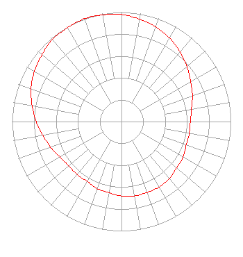 | |||||||||||||||||||||||||
| Azimuth | Ratio | Azimuth | Ratio | Azimuth | Ratio | Azimuth | Ratio | |||||||||||||||||||
| 0 | 0.980 | 10 | 0.950 | 20 | 0.920 | 30 | 0.880 | |||||||||||||||||||
| 40 | 0.830 | 50 | 0.780 | 60 | 0.730 | 70 | 0.690 | |||||||||||||||||||
| 80 | 0.650 | 90 | 0.630 | 100 | 0.630 | 110 | 0.630 | |||||||||||||||||||
| 120 | 0.650 | 130 | 0.660 | 140 | 0.680 | 150 | 0.690 | |||||||||||||||||||
| 160 | 0.690 | 170 | 0.690 | 180 | 0.680 | 190 | 0.660 | |||||||||||||||||||
| 200 | 0.650 | 210 | 0.630 | 220 | 0.630 | 230 | 0.630 | |||||||||||||||||||
| 240 | 0.650 | 250 | 0.690 | 260 | 0.730 | 270 | 0.780 | |||||||||||||||||||
| 280 | 0.830 | 290 | 0.880 | 300 | 0.920 | 310 | 0.950 | |||||||||||||||||||
| 320 | 0.980 | 330 | 0.990 | 340 | 1.000 | 350 | 0.990 | |||||||||||||||||||
Structure Registration Number 1031648 Structure Type: BANT Registered To: OBS REIT, LLC Structure Address: 1 Beacon St Boston, MA County Name: Suffolk County ASR Issued: 08/03/2023 Date Built: 01/24/1997 Site Elevation: 18.8 m (62 ft.) Structure Height: 175.5 m (576 ft.) Height Overall: 191.7 m (629 ft.) Overall Height AMSL: 210.5 m (691 ft.) FAA Determination: 08/15/2022 FAA Study #: 2022-ANE-1367-OE FAA Circular #: 70/7460-1M Paint & Light FAA Chapters: 4, 8, 15 PRIOR STUDY 2019-ANE-2453-OE 42-21-31.0 N 71-03-39.0 W (NAD 83) 42-21-30.6 N 71-03-40.8 W (Converted to NAD 27) |
482 Harbor Drive North Indian Rocks Beach, FL 33785 Phone: 607-738-5623 Limited Liability Company | Title: President Date: 02/23/2024 Application Certifier Milachi Media, Llc 482 Harbor Drive North Indian Rocks Beach, FL 33785 Applicant Mark Denbo Smithwick & Belendiuk, P.c. 5028 Wisconsin Avenue, N.w. Suite 301 Washington, DC 20016 Counsel Clarence M Beverage Communications Technologies 23 Binsted Drive Medford, NJ 08055 Broadcast Engineering Consultant | ||||||||||||||||||||||||