
FCCInfo.com
A Service of Cavell, Mertz & Associates, Inc.
(855) FCC-INFO
|
|
K04SE-D from 10/17/2013 |
|
|
||||||||||||||||
|
|
Status: Application Application Accepted: 02/28/2024 License Expires: 10/01/2030 File Number: -0000239953 FCC Website Links: LMS Facility Details This Application Other K04SE-D Applications Including Superseded Applications Mailing Address Correspondence for K04SE-D Correspondence related to application -0000239953 Service Contour - Open Street Map or USGS Map (43 dBu) Service Contour - KML / Google Earth (43 dBu) Rabbit Ears Info Search for K04SE-D Site Location: 33-31-54.9 N 113-06-31.9 W (NAD 83) Site Location: 33-31-54.8 N 113-06-29.2 W (Converted to NAD 27) ERP: 1 kW Polarization: Horizontally polarized R/C AGL: 66.4 m (218 ft.) R/C AMSL: 560.8 m (1840 ft.) Emission Mask: Stringent Site Elevation: 494.4 m. (1622 ft.) Height Overall*: 78.3 m (257 ft.) (* As Filed In This Application, may differ from ASR Data, Below.) Directional Antenna - Antenna Make/Model: SAMCO SAM-137 back-to-back Antenna ID: 1011509 Polarization: Horizontally polarized
| ||||||||||||||||||
| Antenna Data for Antenna Id: 1011509 K04SE-D LD File: -0000239953 SAMCO - SAM-137 back-to-back Service: LD Standard Pattern: N Pattern and Field Values Include a 290° Clockwise Rotation | 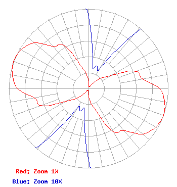 | ||||||||||||||||||
| Azimuth | Ratio | Azimuth | Ratio | Azimuth | Ratio | Azimuth | Ratio | ||||||||||||
| 0 | 0.090 | 10 | 0.030 | 20 | 0.030 | 30 | 0.030 | ||||||||||||
| 40 | 0.090 | 50 | 0.200 | 60 | 0.320 | 70 | 0.630 | ||||||||||||
| 80 | 0.690 | 90 | 0.890 | 100 | 0.970 | 110 | 1.000 | ||||||||||||
| 120 | 0.970 | 130 | 0.890 | 140 | 0.690 | 150 | 0.630 | ||||||||||||
| 160 | 0.320 | 170 | 0.200 | 180 | 0.090 | 190 | 0.030 | ||||||||||||
| 200 | 0.030 | 210 | 0.030 | 220 | 0.090 | 230 | 0.200 | ||||||||||||
| 240 | 0.320 | 250 | 0.630 | 260 | 0.690 | 270 | 0.890 | ||||||||||||
| 280 | 0.970 | 290 | 1.000 | 300 | 0.970 | 310 | 0.890 | ||||||||||||
| 320 | 0.690 | 330 | 0.630 | 340 | 0.320 | 350 | 0.200 | ||||||||||||
Structure Registration Number 1058111 Structure Type: LTOWER Registered To: American Towers LLC Structure Address: 1.3 Miles E. Of Exit 81 On I-10 (burnt Mtn #8396) Tonopah, AZ County Name: Maricopa County ASR Issued: 03/03/2015 Date Built: 08/29/2001 Site Elevation: 494.4 m (1622 ft.) Structure Height: 76.2 m (250 ft.) Height Overall: 78.3 m (257 ft.) Overall Height AMSL: 572.7 m (1879 ft.) FAA Determination: 02/10/2015 FAA Study #: 2014-AWP-9804-OE FAA Circular #: 70/7460-1K Paint & Light FAA Chapters: 4, 8, 12 PRIOR STUDY 2005-AWP-5909-OE 33-31-54.9 N 113-06-31.9 W (NAD 83) 33-31-54.8 N 113-06-29.2 W (Converted to NAD 27) |
14 Tuxedo Drive Beaufort, SC 29907 Phone: 717-226-3535 Limited Liability Company | Title: Manager Date: 02/28/2024 Application Certifier Lowcountry 34 Media, Llc 14 Tuxedo Drive Beaufort, SC 29907 Applicant Darryl K DeLawder Delawder Communications, Inc. P. O. Box 1095 Ashburn, VA 20146-1095 President Davina Sashkin Wilkinson Barker Knauer, Llp 1800 M Street, Nw Suite 800n Washington, DC 20036 | |||||||||||||||||