
FCCInfo.com
A Service of Cavell, Mertz & Associates, Inc.
(855) FCC-INFO
|
|
KTXH from 10/27/1980 |
Virtual Channel 20 |
|
|||||||||||||||||||
|
|
Repacking Information: No changes Status: License Application Accepted: 03/06/2024 License Expires: 08/01/2030 File Number: -0000240451 FCC Website Links: LMS Facility Details This Application Other KTXH Applications Including Superseded Applications Mailing Address Correspondence for KTXH Correspondence related to application -0000240451 Service Contour - Open Street Map or USGS Map (41 dBu) Service Contour - KML / Google Earth (41 dBu) Public Inspection Files History Cards for KTXH Rabbit Ears Info Search for KTXH Site Location: 29-34-29.0 N 95-29-38.0 W (NAD 83) Site Location: 29-34-28.2 N 95-29-37.2 W (Converted to NAD 27) ERP: 1000 kW Polarization: Elliptically polarized HAAT: 598 m (1962 ft.) Electrical Beam Tilt: 1.0 degree R/C AGL: 573.2 m (1881 ft.) R/C AMSL: 597.2 m (1959 ft.) Site Elevation: 24 m. (79 ft.) Height Overall*: 600.4 m (1970 ft.) (* As Filed In This Application, may differ from ASR Data, Below.) Directional Antenna - Antenna Make/Model: R.F. Systems PEP46T Antenna ID: 1011540 Polarization: Elliptically polarized | |||||||||||||||||||||
| Antenna Data for Antenna Id: 1011540 KTXH DT File: -0000240451 R.F. Systems - PEP46T Service: DT Standard Pattern: N | 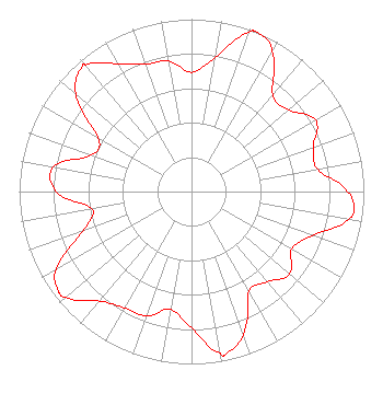 | |||||||||||||||||||||
| Azimuth | Ratio | Azimuth | Ratio | Azimuth | Ratio | Azimuth | Ratio | |||||||||||||||
| 0 | 0.692 | 10 | 0.788 | 20 | 0.982 | 23 | 1.000 | |||||||||||||||
| 30 | 0.939 | 40 | 0.733 | 50 | 0.738 | 60 | 0.830 | |||||||||||||||
| 70 | 0.755 | 80 | 0.743 | 90 | 0.905 | 96 | 0.947 | |||||||||||||||
| 100 | 0.923 | 110 | 0.746 | 120 | 0.669 | 130 | 0.745 | |||||||||||||||
| 140 | 0.685 | 150 | 0.669 | 160 | 0.881 | 168 | 0.961 | |||||||||||||||
| 170 | 0.952 | 180 | 0.793 | 190 | 0.694 | 200 | 0.767 | |||||||||||||||
| 210 | 0.778 | 220 | 0.829 | 230 | 0.952 | 233 | 0.964 | |||||||||||||||
| 240 | 0.905 | 250 | 0.670 | 260 | 0.585 | 270 | 0.784 | |||||||||||||||
| 280 | 0.814 | 290 | 0.615 | 300 | 0.626 | 310 | 0.877 | |||||||||||||||
| 319 | 0.964 | 320 | 0.961 | 330 | 0.857 | 340 | 0.786 | |||||||||||||||
| 350 | 0.769 | |||||||||||||||||||||
Structure Registration Number 1028555 Structure Type: TOWER Registered To: Fox Television Stations, LLC Structure Address: 5034 Mc Hard Rd Fm2.234 Missouri City, TX County Name: Fort Bend County ASR Issued: 08/12/2015 Date Built: 05/01/1982 Site Elevation: 24 m (79 ft.) Structure Height: 580.9 m (1906 ft.) Height Overall: 600.4 m (1970 ft.) Overall Height AMSL: 624.4 m (2049 ft.) FAA Determination: 09/17/1980 FAA Study #: 79-SW-1902-OE Paint & Light FAA Chapters: A1, B, G, H HIGH INTENSITY WHITE LIGHTS 29-34-29.0 N 95-29-38.0 W (NAD 83) 29-34-28.2 N 95-29-37.2 W (Converted to NAD 27) |
101 Constitution Avenue, Nw Suite 200 West Washington, DC 20001 Phone: 202-824-6503 Limited Liability Company | Title: Vp, Fcc Legal And Business Affairs Date: 03/06/2024 Application Certifier Fox Television Stations, Llc 101 Constitution Avenue, Nw Suite 200 West Washington, DC 20001 Applicant Ann West Bobeck Fox Television Stations, Llc 101 Constitution Avenue Nw Suite 200 West Washington, DC 20001 VP, FCC Legal and Business Affairs JOSEPH M. DI SCIPIO Fox Television Stations, Llc 101 Constitution Avenue Nw Suite 200 West Washington, DC 20001 SVP, Legal and Business Affairs and Assistant General Counsel | ||||||||||||||||||||
| ||||||||||||||||||||||
