
FCCInfo.com
A Service of Cavell, Mertz & Associates, Inc.
(855) FCC-INFO
|
|
WIIC-LD from 08/24/2015 WIIC-LD from 09/22/2011 WIIC-LD from 08/06/2010 WIIC-LD from 02/06/2002 WIIC-LD from 04/06/1995 WIIC-LD from 02/03/1995 WIIC-LD from 08/23/1989 |
|
|
||||||||||||||||
|
|
Status: License Application Accepted: 03/08/2024 License Expires: 08/01/2023 File Number: -0000240578 FCC Website Links: LMS Facility Details This Application Other WIIC-LD Applications Including Superseded Applications Mailing Address Correspondence for WIIC-LD Correspondence related to application -0000240578 Service Contour - Open Street Map or USGS Map (48 dBu) Service Contour - KML / Google Earth (48 dBu) Rabbit Ears Info Search for WIIC-LD Site Location: 40-26-23.8 N 79-43-08.3 W (NAD 83) Site Location: 40-26-23.6 N 79-43-09.1 W (Converted to NAD 27) ERP: 3 kW Polarization: Elliptically polarized Electrical Beam Tilt: 1 degree R/C AGL: 210.3 m (690 ft.) R/C AMSL: 582.1 m (1910 ft.) Emission Mask: Full Service Site Elevation: 371.8 m. (1220 ft.) Height Overall*: 237.4 m (779 ft.) (* As Filed In This Application, may differ from ASR Data, Below.) Directional Antenna - Antenna Make/Model: Kathrein 2x2 DRV Antenna ID: 1011547 Polarization: Elliptically polarized | ||||||||||||||||||
| Antenna Data for Antenna Id: 1011547 WIIC-LD LD File: -0000240578 Kathrein - 2x2 DRV Service: LD Standard Pattern: N Pattern and Field Values Include a 220° Clockwise Rotation | 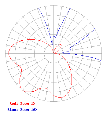 | ||||||||||||||||||
| Azimuth | Ratio | Azimuth | Ratio | Azimuth | Ratio | Azimuth | Ratio | ||||||||||||
| 0 | 0.035 | 10 | 0.039 | 20 | 0.096 | 30 | 0.196 | ||||||||||||
| 40 | 0.241 | 50 | 0.196 | 60 | 0.096 | 70 | 0.039 | ||||||||||||
| 80 | 0.035 | 86 | 0.019 | 90 | 0.032 | 100 | 0.115 | ||||||||||||
| 110 | 0.208 | 120 | 0.308 | 130 | 0.431 | 140 | 0.581 | ||||||||||||
| 150 | 0.743 | 160 | 0.879 | 170 | 0.931 | 180 | 0.871 | ||||||||||||
| 190 | 0.761 | 194 | 0.742 | 200 | 0.771 | 210 | 0.918 | ||||||||||||
| 220 | 1.000 | 230 | 0.918 | 240 | 0.771 | 245 | 0.742 | ||||||||||||
| 250 | 0.761 | 260 | 0.871 | 270 | 0.931 | 280 | 0.879 | ||||||||||||
| 290 | 0.743 | 300 | 0.581 | 310 | 0.431 | 320 | 0.309 | ||||||||||||
| 330 | 0.208 | 340 | 0.115 | 350 | 0.032 | 354 | 0.019 | ||||||||||||
Structure Registration Number 1026130 Structure Type: GTOWER Registered To: American Towers LLC Structure Address: 800 Hawkeye Drive Extended (#207196) Monroeville, PA County Name: Allegheny County ASR Issued: 08/15/2023 Date Built: 12/20/1978 Site Elevation: 371.8 m (1220 ft.) Structure Height: 235.5 m (773 ft.) Height Overall: 237.4 m (779 ft.) Overall Height AMSL: 609.2 m (1999 ft.) FAA Determination: 07/20/2022 FAA Study #: 2022-AEA-7137-OE FAA Circular #: 70/7460-1K Paint & Light FAA Chapters: 3, 4, 5, 12 PRIOR STUDIES 2000-AEA-4127-OE / 2021-AEA-16385-OE 40-26-23.8 N 79-43-08.3 W (NAD 83) 40-26-23.6 N 79-43-09.1 W (Converted to NAD 27) |
Abacus Television 4310 Brownsville Road Pittsburgh, PA 15236 Phone: 202-841-4104 Sole Proprietor | Title: Owner, Abacus Television Date: 03/08/2024 Application Certifier Abacus Television Abacus Television Abacus Television 4310 Brownsville Road Pittsburgh, PA 15236 Applicant Darryl K DeLawder Delawder Communications, Inc. P. O. Box 1095 Ashburn, VA 20146 President Benjamin Perez Abacus Communications Company Benjamin Perez 4310 Brownsville Road Pittsburgh, PA 15236 Its Attorney | |||||||||||||||||