
FCCInfo.com
A Service of Cavell, Mertz & Associates, Inc.
(855) FCC-INFO
|
|
|
|
|
||||||||||||||||
|
|
Status: Construction Permit (Licensed And Silent) Application Accepted: 03/18/2024 K03II-D CP Expires: 02/20/2027 File Number: -0000241431 FCC Website Links: LMS Facility Details This Application Other K03II-D Applications Including Superseded Applications Mailing Address Correspondence for K03II-D Correspondence related to application -0000241431 Service Contour - Open Street Map or USGS Map (43 dBu) Service Contour - KML / Google Earth (43 dBu) Rabbit Ears Info Search for K03II-D Site Location: 38-58-34.0 N 95-48-34.0 W (NAD 83) Site Location: 38-58-34.0 N 95-48-33.1 W (Converted to NAD 27) ERP: 0.1 kW Polarization: Horizontally polarized R/C AGL: 12.2 m (40 ft.) R/C AMSL: 367.3 m (1205 ft.) Emission Mask: Full Service Site Elevation: 355.1 m. (1165 ft.) Height Overall*: 152.1 m (499 ft.) (* As Filed In This Application, may differ from ASR Data, Below.) Directional Antenna - Antenna Make/Model: Kathrein CL-24 Antenna ID: 38574 Polarization: Horizontally polarized | ||||||||||||||||||
| Antenna Data for Antenna Id: 38574 K03II-D LD File: -0000241431 Kathrein - CL-24 Service: LD Standard Pattern: Y Pattern and Field Values Include a 40° Clockwise Rotation | 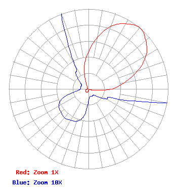 | ||||||||||||||||||
| Azimuth | Ratio | Azimuth | Ratio | Azimuth | Ratio | Azimuth | Ratio | ||||||||||||
| 0 | 0.460 | 10 | 0.655 | 20 | 0.835 | 30 | 0.940 | ||||||||||||
| 40 | 1.000 | 50 | 0.940 | 60 | 0.835 | 70 | 0.655 | ||||||||||||
| 80 | 0.460 | 90 | 0.295 | 100 | 0.105 | 110 | 0.035 | ||||||||||||
| 120 | 0.025 | 130 | 0.015 | 140 | 0.010 | 150 | 0.010 | ||||||||||||
| 160 | 0.010 | 170 | 0.010 | 180 | 0.015 | 190 | 0.035 | ||||||||||||
| 200 | 0.043 | 210 | 0.045 | 220 | 0.047 | 230 | 0.045 | ||||||||||||
| 240 | 0.043 | 250 | 0.035 | 260 | 0.015 | 270 | 0.010 | ||||||||||||
| 280 | 0.010 | 290 | 0.010 | 300 | 0.010 | 310 | 0.015 | ||||||||||||
| 320 | 0.025 | 330 | 0.035 | 340 | 0.105 | 350 | 0.295 | ||||||||||||
Structure Registration Number 1276612 Structure Type: GTOWER Registered To: Heartland Tower, Inc. Structure Address: 5030 Sw Auburn Rd. Topeka, KS County Name: Shawnee County ASR Issued: 09/27/2017 Date Built: 08/28/2012 Site Elevation: 355.1 m (1165 ft.) Structure Height: 146.3 m (480 ft.) Height Overall: 152.1 m (499 ft.) Overall Height AMSL: 507.2 m (1664 ft.) FAA Determination: 06/22/2011 FAA Study #: 2009-ACE-2062-OE FAA Circular #: 70/7460-1K Paint & Light FAA Chapters: 4, 6, 12 PRIOR STUDY 2009-ACE-1389-OE 38-58-34.0 N 95-48-34.0 W (NAD 83) 38-58-34.0 N 95-48-33.1 W (Converted to NAD 27) |
888c 8th Avenue Suite 733 New York, NY 10019 Phone: 212-580-1349 Corporation | Title: President Date: 03/18/2024 Application Certifier Roseland Broadcasting, Inc. 888c 8th Avenue Suite 733 New York, NY 10019 Applicant Clarence M Beverage Communications Technologies 23 Binsted Drive Medford, NJ 08055 Broadcast Engineering Consultant Aaron P Shainis Shainis & Peltzman, Chartered 1850 M St. Nw Suite 240 Washington, DC 20036 Legal Counsel | |||||||||||||||||