
FCCInfo.com
A Service of Cavell, Mertz & Associates, Inc.
(855) FCC-INFO
|
|
WKDC-LD from 10/13/2010 WKDC-LD from 06/02/2008 WKDC-LD from 04/26/2002 WKDC-LD from 08/21/1990 |
|
|
||||||||||||||||
|
|
Status: Construction Permit Application Accepted: 03/18/2024 WKDC-LD CP Expires: 09/27/2021 File Number: -0000241440 FCC Website Links: LMS Facility Details This Application Other WKDC-LD Applications Including Superseded Applications Mailing Address Correspondence for WKDC-LD Correspondence related to application -0000241440 Service Contour - Open Street Map or USGS Map (51 dBu) Service Contour - KML / Google Earth (51 dBu) Rabbit Ears Info Search for WKDC-LD Site Location: 34-06-58.4 N 80-45-49.9 W (NAD 83) Site Location: 34-06-57.9 N 80-45-50.6 W (Converted to NAD 27) ERP: 15 kW Polarization: Horizontally polarized R/C AGL: 122 m (400 ft.) R/C AMSL: 208.8 m (685 ft.) Emission Mask: Full Service Site Elevation: 86.8 m. (285 ft.) Height Overall*: 537.7 m (1764 ft.) (* As Filed In This Application, may differ from ASR Data, Below.) Directional Antenna - Antenna Make/Model: Systems With Reliability Inc. SWEDL4ECRR/16-H Antenna ID: 1011566 Polarization: Horizontally polarized | ||||||||||||||||||
| Antenna Data for Antenna Id: 1011566 WKDC-LD LD File: -0000241440 Systems With Reliability Inc. - SWEDL4ECRR/16-H Service: LD Standard Pattern: N Pattern and Field Values Include a 250° Clockwise Rotation | 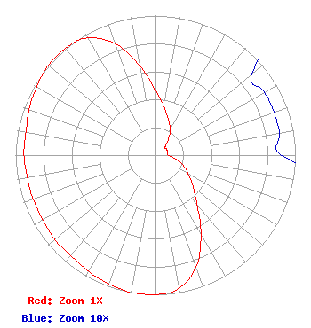 | ||||||||||||||||||
| Azimuth | Ratio | Azimuth | Ratio | Azimuth | Ratio | Azimuth | Ratio | ||||||||||||
| 0 | 0.460 | 10 | 0.350 | 20 | 0.270 | 30 | 0.210 | ||||||||||||
| 40 | 0.140 | 50 | 0.090 | 60 | 0.090 | 70 | 0.090 | ||||||||||||
| 80 | 0.090 | 90 | 0.090 | 100 | 0.140 | 110 | 0.210 | ||||||||||||
| 120 | 0.270 | 130 | 0.350 | 140 | 0.460 | 150 | 0.650 | ||||||||||||
| 160 | 0.850 | 170 | 0.970 | 180 | 1.000 | 190 | 1.000 | ||||||||||||
| 200 | 0.980 | 210 | 0.960 | 220 | 0.940 | 230 | 0.940 | ||||||||||||
| 240 | 0.930 | 250 | 0.930 | 260 | 0.930 | 270 | 0.940 | ||||||||||||
| 280 | 0.940 | 290 | 0.960 | 300 | 0.980 | 310 | 1.000 | ||||||||||||
| 320 | 1.000 | 330 | 0.970 | 340 | 0.850 | 350 | 0.650 | ||||||||||||
Structure Registration Number 1055358 Structure Type: GTOWER Registered To: American Towers LLC Structure Address: 1811 Rush Rd (#023657) Elgin, SC County Name: Kershaw County ASR Issued: 08/23/2023 Date Built: 03/05/2001 Site Elevation: 86.8 m (285 ft.) Structure Height: 516.9 m (1696 ft.) Height Overall: 537.7 m (1764 ft.) Overall Height AMSL: 624.5 m (2049 ft.) FAA Determination: 04/07/2023 FAA Study #: 2022-ASO-44876-OE FAA Circular #: 70/7460-1M Paint & Light FAA Chapters: 4, 9, 15 PRIOR STUDY 2006-ASO-728-OE 34-06-58.4 N 80-45-49.9 W (NAD 83) 34-06-57.9 N 80-45-50.6 W (Converted to NAD 27) |
3901 Highway 121 Bedford, TX 76021 Phone: 817-571-1229 Not-for-Profit | Title: Manager Date: 03/18/2024 Application Certifier Word Of God Fellowship, Inc. 3901 Highway 121 Bedford, TX 76021 Applicant Mark Denbo Smithwick & Belendiuk, P.c. 5028 Wisconsin Avenue, N.w. Suite 301 Washington, DC 20016 Counsel RICHARD C. GOETZ R & L Media Systems 135 N. Country Club Dr. Hendersonville, TN 37075 BROADCAST CONSULTANT | |||||||||||||||||