
FCCInfo.com
A Service of Cavell, Mertz & Associates, Inc.
(855) FCC-INFO
|
|
W33EM-D from 03/20/1997 W33EM-D from 07/23/1985 |
|
|
||||||||||||||||
|
|
Status: Construction Permit Application Accepted: 03/21/2024 W33EM-D CP Expires: 02/28/2026 File Number: -0000241613 FCC Website Links: LMS Facility Details This Application Other W33EM-D Applications Including Superseded Applications Mailing Address Correspondence for W33EM-D Correspondence related to application -0000241613 Service Contour - Open Street Map or USGS Map (51 dBu) Service Contour - KML / Google Earth (51 dBu) Rabbit Ears Info Search for W33EM-D Site Location: 40-09-24.5 N 79-19-31.4 W (NAD 83) Site Location: 40-09-24.2 N 79-19-32.3 W (Converted to NAD 27) ERP: 2.5 kW Polarization: Horizontally polarized R/C AGL: 35 m (115 ft.) R/C AMSL: 562.9 m (1847 ft.) Emission Mask: Full Service Site Elevation: 527.9 m. (1732 ft.) Height Overall*: 78.6 m (258 ft.) (* As Filed In This Application, may differ from ASR Data, Below.) Directional Antenna - Antenna Make/Model: Scala PRTV 110/330 Antenna ID: 1011572 Polarization: Horizontally polarized
| ||||||||||||||||||
| Antenna Data for Antenna Id: 1011572 W33EM-D LD File: -0000241613 Scala - PRTV 110/330 Service: LD Standard Pattern: N Pattern and Field Values Include a 110° Clockwise Rotation | 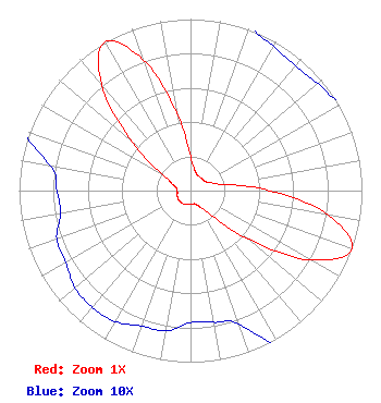 | ||||||||||||||||||
| Azimuth | Ratio | Azimuth | Ratio | Azimuth | Ratio | Azimuth | Ratio | ||||||||||||
| 0 | 0.203 | 10 | 0.131 | 20 | 0.103 | 30 | 0.097 | ||||||||||||
| 40 | 0.095 | 50 | 0.097 | 60 | 0.103 | 70 | 0.131 | ||||||||||||
| 80 | 0.203 | 90 | 0.458 | 100 | 0.817 | 110 | 1.000 | ||||||||||||
| 120 | 0.807 | 130 | 0.442 | 140 | 0.184 | 150 | 0.111 | ||||||||||||
| 160 | 0.083 | 170 | 0.078 | 180 | 0.077 | 190 | 0.083 | ||||||||||||
| 200 | 0.084 | 210 | 0.088 | 220 | 0.089 | 230 | 0.088 | ||||||||||||
| 240 | 0.084 | 250 | 0.083 | 260 | 0.077 | 270 | 0.078 | ||||||||||||
| 280 | 0.083 | 290 | 0.111 | 300 | 0.184 | 310 | 0.442 | ||||||||||||
| 320 | 0.807 | 330 | 1.000 | 340 | 0.817 | 350 | 0.458 | ||||||||||||
Structure Registration Number 1290414 Structure Type: LTOWER Registered To: American Towers LLC Structure Address: 138 Old 711 Road Stahlstown, PA County Name: Westmoreland County ASR Issued: 02/06/2014 Date Built: 03/28/2014 Site Elevation: 527.9 m (1732 ft.) Structure Height: 76.2 m (250 ft.) Height Overall: 78.6 m (258 ft.) Overall Height AMSL: 606.5 m (1990 ft.) FAA Determination: 07/09/2013 FAA Study #: 2013-AEA-1784-OE FAA Circular #: 70/7460-1K Paint & Light FAA Chapters: 4, 8, 12 Removed expiration date from determination. Scenario 1./jjs/case#635066 40-09-24.5 N 79-19-31.4 W (NAD 83) 40-09-24.2 N 79-19-32.3 W (Converted to NAD 27) |
Chattanooga, TN 37401 Phone: 423-468-5100 Limited Liability Company | Title: Coo Date: 03/21/2024 Application Certifier DIGITAL NETWORKS-NORTHEAST, LLC Digital Networks-northeast, Llc Chattanooga, TN 37401 Applicant Timothy Z Sawyer Tz Sawyer Technical Consultants 2130 Hutchison Grove Court Suite 100 Falls Church, VA 22043 Technical Consultant Aaron P Shainis Shainis & Peltzman, Chartered 1850 M St. Nw Suite 240 Washington, DC 20036 FCC Legal Counsel | |||||||||||||||||