
FCCInfo.com
A Service of Cavell, Mertz & Associates, Inc.
(855) FCC-INFO
|
|
K31PO-D from 10/09/1998 |
|
|
||||||||||||||||
|
|
Status: Construction Permit Application Accepted: 03/22/2024 K31PO-D CP Expires: 02/28/2026 File Number: -0000241774 FCC Website Links: LMS Facility Details This Application Other K31PO-D Applications Including Superseded Applications Mailing Address Correspondence for K31PO-D Correspondence related to application -0000241774 Service Contour - Open Street Map or USGS Map (51 dBu) Service Contour - KML / Google Earth (51 dBu) Rabbit Ears Info Search for K31PO-D Site Location: 41-50-11.1 N 93-17-03.1 W (NAD 83) Site Location: 41-50-11.1 N 93-17-02.4 W (Converted to NAD 27) ERP: 2.5 kW Polarization: Horizontally polarized R/C AGL: 35 m (115 ft.) R/C AMSL: 331.9 m (1089 ft.) Emission Mask: Full Service Site Elevation: 296.9 m. (974 ft.) Height Overall*: 106.7 m (350 ft.) (* As Filed In This Application, may differ from ASR Data, Below.) Directional Antenna - Antenna Make/Model: Scala PRTV 45/270 Antenna ID: 1011581 Polarization: Horizontally polarized
| ||||||||||||||||||
| Antenna Data for Antenna Id: 1011581 K31PO-D LD File: -0000241774 Scala - PRTV 45/270 Service: LD Standard Pattern: N Pattern and Field Values Include a 45.0° Clockwise Rotation | 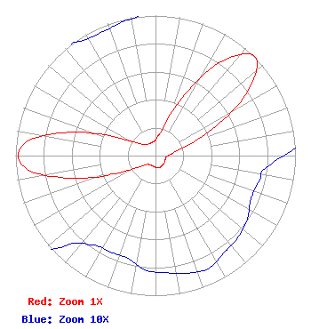 | ||||||||||||||||||
| Azimuth | Ratio | Azimuth | Ratio | Azimuth | Ratio | Azimuth | Ratio | ||||||||||||
| 5 | 0.132 | 15 | 0.202 | 25 | 0.459 | 35 | 0.819 | ||||||||||||
| 45 | 1.000 | 55 | 0.810 | 65 | 0.442 | 75 | 0.185 | ||||||||||||
| 85 | 0.111 | 95 | 0.081 | 105 | 0.076 | 115 | 0.075 | ||||||||||||
| 125 | 0.080 | 135 | 0.083 | 145 | 0.085 | 155 | 0.089 | ||||||||||||
| 165 | 0.087 | 175 | 0.084 | 185 | 0.082 | 195 | 0.076 | ||||||||||||
| 205 | 0.076 | 215 | 0.078 | 225 | 0.091 | 235 | 0.141 | ||||||||||||
| 245 | 0.287 | 255 | 0.626 | 265 | 0.943 | 275 | 0.946 | ||||||||||||
| 285 | 0.641 | 295 | 0.304 | 305 | 0.159 | 315 | 0.113 | ||||||||||||
| 325 | 0.099 | 335 | 0.096 | 345 | 0.098 | 355 | 0.103 | ||||||||||||
Structure Registration Number 1228847 Structure Type: TOWER Registered To: SpectraSite Communications, LLC. through American Towers, LLC. Structure Address: N. 99th Street W Baxter, IA County Name: Jasper County ASR Issued: 01/16/2013 Date Built: 06/22/2002 Site Elevation: 296.9 m (974 ft.) Structure Height: 102.1 m (335 ft.) Height Overall: 106.7 m (350 ft.) Overall Height AMSL: 403.6 m (1324 ft.) FAA Determination: 02/08/2007 FAA Study #: 2007-ACE-69-OE FAA Circular #: 70/7460-1K Paint & Light FAA Chapters: 4, 8, 12 OM&L to remain the same as prior study = A MED-DUAL SYSTEM 41-50-11.1 N 93-17-03.1 W (NAD 83) 41-50-11.1 N 93-17-02.4 W (Converted to NAD 27) |
Chattanooga, TN 37401 Phone: 423-468-5100 Limited Liability Company | Title: Coo Date: 03/22/2024 Application Certifier DIGITAL NETWORKS-MIDWEST, LLC Digital Networks-midwest, Llc Chattanooga, TN 37401 Applicant Timothy Z Sawyer T Z Sawyer Technical Consultants 2130 Hutchison Grove Court Suite 100 Falls Church, VA 22043 Technical Consultant Aaron P Shainis, Esq Shainis & Peltzman Chartered 1850 M Street Nw Suite 240 Washington, DC 20036 FCC Legal Counsel | |||||||||||||||||