
FCCInfo.com
A Service of Cavell, Mertz & Associates, Inc.
(855) FCC-INFO
|
|
W25FP-D from 12/14/2009 |
|
|
||||||||||||||||
|
|
Status: License Application Accepted: 04/10/2024 License Expires: 04/01/2029 File Number: -0000243330 FCC Website Links: LMS Facility Details This Application Other W25FP-D Applications Including Superseded Applications Mailing Address Correspondence for W25FP-D Correspondence related to application -0000243330 Service Contour - Open Street Map or USGS Map (51 dBu) Service Contour - KML / Google Earth (51 dBu) Rabbit Ears Info Search for W25FP-D Site Location: 34-57-13.5 N 83-43-48.8 W (NAD 83) Site Location: 34-57-13.2 N 83-43-49.2 W (Converted to NAD 27) ERP: 4.7 kW Polarization: Elliptically polarized Electrical Beam Tilt: 0.50 degrees R/C AGL: 56.9 m (187 ft.) R/C AMSL: 1025.2 m (3364 ft.) Emission Mask: Full Service Site Elevation: 968.3 m. (3177 ft.) Height Overall*: 65.2 m (214 ft.) (* As Filed In This Application, may differ from ASR Data, Below.) Directional Antenna - Antenna Make/Model: Dielectric TUM-LP-C3-2/6M-1-K Antenna ID: 1011625 Polarization: Elliptically polarized
| ||||||||||||||||||
| Antenna Data for Antenna Id: 1011625 W25FP-D LD File: -0000243330 Dielectric - TUM-LP-C3-2/6M-1-K Service: LD Standard Pattern: N Pattern and Field Values Include a 270° Clockwise Rotation | 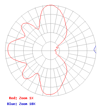 | ||||||||||||||||||
| Azimuth | Ratio | Azimuth | Ratio | Azimuth | Ratio | Azimuth | Ratio | ||||||||||||
| 0 | 1.000 | 10 | 0.939 | 20 | 0.811 | 30 | 0.665 | ||||||||||||
| 40 | 0.559 | 50 | 0.403 | 60 | 0.157 | 70 | 0.176 | ||||||||||||
| 80 | 0.115 | 90 | 0.096 | 100 | 0.126 | 110 | 0.134 | ||||||||||||
| 120 | 0.154 | 130 | 0.399 | 140 | 0.563 | 150 | 0.658 | ||||||||||||
| 160 | 0.767 | 170 | 0.901 | 180 | 0.964 | 190 | 0.925 | ||||||||||||
| 200 | 0.690 | 210 | 0.572 | 220 | 0.812 | 230 | 0.806 | ||||||||||||
| 240 | 0.606 | 250 | 0.713 | 260 | 0.878 | 270 | 0.938 | ||||||||||||
| 280 | 0.913 | 290 | 0.745 | 300 | 0.650 | 310 | 0.835 | ||||||||||||
| 320 | 0.786 | 330 | 0.542 | 340 | 0.689 | 350 | 0.929 | ||||||||||||
Structure Registration Number 1020228 Structure Type: LTOWER Registered To: CCATT LLC Structure Address: 50 Shake Rag Road Hiawassee, GA County Name: Towns County ASR Issued: 05/09/2016 Date Built: 04/29/1995 Site Elevation: 968.3 m (3177 ft.) Structure Height: 61 m (200 ft.) Height Overall: 65.2 m (214 ft.) Overall Height AMSL: 1033.5 m (3391 ft.) FAA Determination: 03/07/1995 FAA Study #: 95-ASO-0158-OE FAA Circular #: 70/7460-1H Paint & Light FAA Chapters: 4, 5, 6, 8, 13 34-57-13.5 N 83-43-48.8 W (NAD 83) 34-57-13.2 N 83-43-49.2 W (Converted to NAD 27) |
260 14th St Nw Atlanta, GA 30318 Phone: 404-685-2619 Government Entity | Title: Chief Operating Officer Date: 04/10/2024 Application Certifier Georgia Public Telecommunications Commission 260 14th St Nw Atlanta, GA 30318 Applicant Derek Teslik Gray Miller Persh Llp 2233 Wisconsin Ave., Nw Ste. 226 Washington, DC 20007 Joshua Turiel Gray Miller Persh Llp 2233 Wisconsin Avenue, Nw Suite 226 Washington, DC 20007 Ryan C Wilhour Kessler And Gehman Associates, Inc. 14260 W Newberry Road #412 Ste D Newberry, FL 32669 Consulting Engineer | |||||||||||||||||