
FCCInfo.com
A Service of Cavell, Mertz & Associates, Inc.
(855) FCC-INFO
|
|
W30EZ-D from 05/17/2011 |
|
|
||||||||||||||||
|
|
Status: License Application Accepted: 04/08/2024 License Expires: 06/01/2029 File Number: -0000243221 FCC Website Links: LMS Facility Details This Application Other W30EZ-D Applications Including Superseded Applications Mailing Address Correspondence for W30EZ-D Correspondence related to application -0000243221 Service Contour - Open Street Map or USGS Map (51 dBu) Service Contour - KML / Google Earth (51 dBu) Rabbit Ears Info Search for W30EZ-D Site Location: 30-40-51.5 N 89-45-44.7 W (NAD 83) Site Location: 30-40-50.8 N 89-45-44.4 W (Converted to NAD 27) ERP: 15 kW Polarization: Horizontally polarized Electrical Beam Tilt: 1.0 degree R/C AGL: 80.3 m (263 ft.) R/C AMSL: 139.7 m (458 ft.) Emission Mask: Full Service Site Elevation: 59.4 m. (195 ft.) Height Overall*: 94.8 m (311 ft.) (* As Filed In This Application, may differ from ASR Data, Below.) Directional Antenna - Antenna Make/Model: Propagation System Inc PSILP12BB-30 Antenna ID: 1011616 Polarization: Horizontally polarized | ||||||||||||||||||
| Antenna Data for Antenna Id: 1011616 W30EZ-D LD File: -0000243221 Propagation System Inc - PSILP12BB-30 Service: LD Standard Pattern: N Pattern and Field Values Include a 120° Clockwise Rotation | 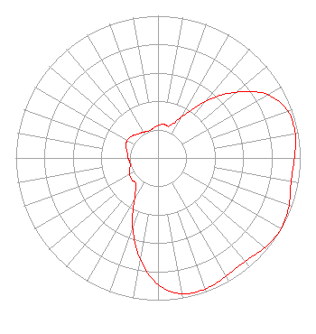 | ||||||||||||||||||
| Azimuth | Ratio | Azimuth | Ratio | Azimuth | Ratio | Azimuth | Ratio | ||||||||||||
| 0 | 0.230 | 10 | 0.240 | 20 | 0.240 | 30 | 0.330 | ||||||||||||
| 40 | 0.520 | 50 | 0.720 | 60 | 0.890 | 70 | 0.970 | ||||||||||||
| 80 | 0.980 | 90 | 0.960 | 100 | 0.950 | 110 | 0.980 | ||||||||||||
| 120 | 1.000 | 130 | 0.980 | 140 | 0.950 | 150 | 0.960 | ||||||||||||
| 160 | 0.980 | 170 | 0.970 | 180 | 0.890 | 190 | 0.720 | ||||||||||||
| 200 | 0.520 | 210 | 0.330 | 220 | 0.240 | 230 | 0.240 | ||||||||||||
| 240 | 0.230 | 250 | 0.210 | 260 | 0.200 | 270 | 0.210 | ||||||||||||
| 280 | 0.220 | 290 | 0.240 | 300 | 0.250 | 310 | 0.240 | ||||||||||||
| 320 | 0.220 | 330 | 0.210 | 340 | 0.200 | 350 | 0.210 | ||||||||||||
Structure Registration Number 1263929 Structure Type: LTOWER Registered To: American Towers LLC Structure Address: 24 Henleyfield-mcneill Road (318320) Carriere, MS County Name: Pearl River County ASR Issued: 12/30/2022 Date Built: 12/04/2008 Site Elevation: 59.4 m (195 ft.) Structure Height: 91.4 m (300 ft.) Height Overall: 94.8 m (311 ft.) Overall Height AMSL: 154.2 m (506 ft.) FAA Determination: 12/20/2022 FAA Study #: 2022-ASO-8677-OE FAA Circular #: 70/7460-1K Paint & Light FAA Chapters: 4, 8, 12 OM&L to remain the same as prior study = A MED-DUAL SYSTEM 30-40-51.5 N 89-45-44.7 W (NAD 83) 30-40-50.8 N 89-45-44.4 W (Converted to NAD 27) |
4370 Peachtree Road, Ne Atlanta, GA 30319 Phone: 202-750-1585 Limited Liability Company | Title: Assistant Secretary Date: 04/08/2024 Application Certifier Gray Television Licensee, Llc 4370 Peachtree Road, Ne Atlanta, GA 30319 Applicant Joseph M. Davis, P.E. Chesapeake Rf Consultants, Llc 207 Old Dominion Road Yorktown, VA 23692 Consulting Engineer Joan Stewart Wiley Rein Llp 2050 M Street, Nw Washington, DC 20036 | |||||||||||||||||