
FCCInfo.com
A Service of Cavell, Mertz & Associates, Inc.
(855) FCC-INFO
|
|
WPFO from 09/08/1998 WPFO from 06/01/1998 |
Post-repack Channel 17 Virtual Channel 23 |  |
|
||||||||||||||||||||||||
|
|
Repacking Information: Pre-Repack Channel: 23 Post-Repack Channel: 17 Post-Repack ERP: 338 kW Phase: 4 Completion Deadline: 8/2/2019 Find nearby TV Facilities Status: License Application Accepted: 04/23/2024 License Expires: 04/01/2023 File Number: -0000242323 FCC Website Links: LMS Facility Details This Application Other WPFO Applications Including Superseded Applications Mailing Address Correspondence for WPFO Correspondence related to application -0000242323 Service Contour - Open Street Map or USGS Map (41 dBu) Service Contour - KML / Google Earth (41 dBu) Public Inspection Files Rabbit Ears Info Search for WPFO Site Location: 43-55-29.0 N 70-29-27.0 W (NAD 83) Site Location: 43-55-28.7 N 70-29-28.8 W (Converted to NAD 27) ERP: 1000 kW Polarization: Elliptically polarized HAAT: 479 m (1572 ft.) Electrical Beam Tilt: 0.75 degrees R/C AGL: 465.5 m (1527 ft.) R/C AMSL: 595 m (1952 ft.) Site Elevation: 129.5 m. (425 ft.) Height Overall*: 495.1 m (1624 ft.) (* As Filed In This Application, may differ from ASR Data, Below.) Directional Antenna - Antenna Make/Model: DIELECTRIC TFU-26DSC/VP-R C130 Antenna ID: 1011646 Polarization: Elliptically polarized | |||||||||||||||||||||||||||
| Antenna Data for Antenna Id: 1011646 WPFO DT File: -0000242323 DIELECTRIC - TFU-26DSC/VP-R C130 Service: DT Standard Pattern: N | 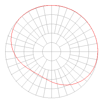 | |||||||||||||||||||||||||||
| Azimuth | Ratio | Azimuth | Ratio | Azimuth | Ratio | Azimuth | Ratio | |||||||||||||||||||||
| 0 | 0.996 | 10 | 0.997 | 20 | 0.999 | 30 | 1.000 | |||||||||||||||||||||
| 40 | 0.999 | 50 | 0.998 | 60 | 0.996 | 70 | 0.997 | |||||||||||||||||||||
| 80 | 0.998 | 90 | 0.998 | 100 | 0.993 | 110 | 0.981 | |||||||||||||||||||||
| 120 | 0.958 | 130 | 0.923 | 140 | 0.878 | 150 | 0.824 | |||||||||||||||||||||
| 160 | 0.764 | 170 | 0.705 | 180 | 0.651 | 190 | 0.609 | |||||||||||||||||||||
| 200 | 0.582 | 210 | 0.573 | 220 | 0.582 | 230 | 0.609 | |||||||||||||||||||||
| 240 | 0.651 | 250 | 0.705 | 260 | 0.764 | 270 | 0.824 | |||||||||||||||||||||
| 280 | 0.878 | 290 | 0.923 | 300 | 0.958 | 310 | 0.981 | |||||||||||||||||||||
| 320 | 0.993 | 330 | 0.998 | 340 | 0.998 | 350 | 0.997 | |||||||||||||||||||||
Structure Registration Number 1024383 Structure Type: TOWER Registered To: WGME Licensee, LLC Structure Address: Brown Hill, 2.0 Mi Ne Raymond, ME County Name: Cumberland County ASR Issued: 01/11/2017 Date Built: 03/31/1975 Site Elevation: 129.5 m (425 ft.) Structure Height: 458.2 m (1503 ft.) Height Overall: 495.1 m (1624 ft.) Overall Height AMSL: 624.6 m (2049 ft.) FAA Determination: 05/16/1997 FAA Study #: 97-ANE-0102-OE Paint & Light FAA Chapters: 1, 3, 10.1, 19.1, 21 RED LIGHTS/PAINT. 43-55-29.0 N 70-29-27.0 W (NAD 83) 43-55-28.7 N 70-29-28.8 W (Converted to NAD 27) |
2000 West 41st Street Baltimore, MD 21211 Phone: 410-662-9688 Corporation | Title: Secretary, Treasurer, Cfo Date: 04/23/2024 Application Certifier Portland (wpfo-tv) Licensee, Inc. 2000 West 41st Street Baltimore, MD 21211 Applicant Scott R. Flick, Esq Pillsbury Winthrop Shaw Pittman Llp 1200 Seventeenth Street, Nw Washington, DC 20036 FCC Counsel Kevin Fisher Smith And Fisher, Llc 4791 Wintergreen Court Woodbridge, VA 22192 | ||||||||||||||||||||||||||
| ||||||||||||||||||||||||||||
