
FCCInfo.com
A Service of Cavell, Mertz & Associates, Inc.
(855) FCC-INFO
|
|
K32EM-D from 08/28/1996 |
|
|
||||||||||||||||
|
|
Status: License Application Accepted: 09/01/2015 License Expires: 12/01/2022 File Number: -0000004554 FCC Website Links: LMS Facility Details This Application Other K32EM-D Applications Including Superseded Applications Mailing Address Correspondence for K32EM-D Correspondence related to application -0000004554 Service Contour - Open Street Map or USGS Map (51 dBu) Service Contour - KML / Google Earth (51 dBu) Rabbit Ears Info Search for K32EM-D Site Location: 34-03-54.0 N 116-32-45.0 W (NAD 83) Site Location: 34-03-54.0 N 116-32-42.0 W (Converted to NAD 27) ERP: 0.435 kW Polarization: Horizontally polarized R/C AGL: 36.6 m (120 ft.) R/C AMSL: 890.0 m (2920 ft.) Emission Mask: Simple Site Elevation: 853.4 m. (2800 ft.) Height Overall*: 60.6 m (199 ft.) (* As Filed In This Application, may differ from ASR Data, Below.) Directional Antenna - Antenna Make/Model: DIELECTRIC TUA-03(SP) 6770 Antenna ID: 109700 Polarization: Horizontally polarized
| ||||||||||||||||||
| Antenna Data for Antenna Id: 109700 K32EM-D LD File: -0000004554 DIELECTRIC - TUA-03(SP) 6770 Service: LD Standard Pattern: Y | 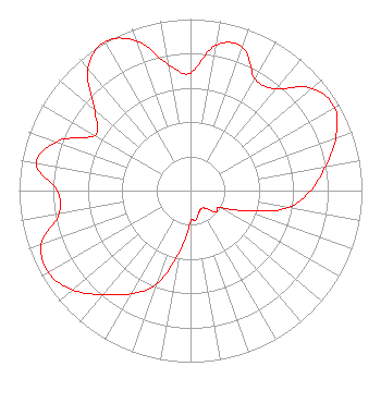 | ||||||||||||||||||
| Azimuth | Ratio | Azimuth | Ratio | Azimuth | Ratio | Azimuth | Ratio | ||||||||||||
| 0 | 0.685 | 10 | 0.860 | 20 | 0.889 | 30 | 0.752 | ||||||||||||
| 40 | 0.774 | 50 | 0.928 | 60 | 0.969 | 70 | 0.902 | ||||||||||||
| 80 | 0.799 | 90 | 0.701 | 100 | 0.578 | 110 | 0.344 | ||||||||||||
| 120 | 0.196 | 130 | 0.194 | 140 | 0.134 | 150 | 0.123 | ||||||||||||
| 160 | 0.139 | 170 | 0.176 | 180 | 0.183 | 190 | 0.361 | ||||||||||||
| 200 | 0.580 | 210 | 0.694 | 220 | 0.792 | 230 | 0.900 | ||||||||||||
| 240 | 0.956 | 250 | 0.926 | 260 | 0.778 | 270 | 0.779 | ||||||||||||
| 280 | 0.914 | 290 | 0.831 | 300 | 0.644 | 310 | 0.729 | ||||||||||||
| 320 | 0.930 | 330 | 1.000 | 340 | 0.930 | 350 | 0.747 | ||||||||||||
Structure Registration Number 1018702 Structure Type: TOWER Registered To: SAN BERNARDINO, COUNTY OF Structure Address: 3 Mi Sw Morongo Valley, CA County Name: San Bernardino County ASR Issued: 04/16/1997 Date Built: 01/01/1992 Site Elevation: 853.4 m (2800 ft.) Structure Height: 60.6 m (199 ft.) Height Overall: 60.6 m (199 ft.) Overall Height AMSL: 914 m (2999 ft.) FAA Determination: 07/17/1992 FAA Study #: 92-AWP-0577-OE Paint & Light FAA Chapters: NONE 34-03-54.0 N 116-32-45.0 W (NAD 83) 34-03-54.0 N 116-32-42.0 W (Converted to NAD 27) |
222 W. Hospitality Lane 2nd Floor San Bernardino, CA 92415 Phone: 909-386-8800 Government Entity | Title: Area Manager Date: 09/01/2015 Application Certifier COUNTY OF SAN BERNARDINO AREA 70-TV2 County Of San Bernardino Area 70-tv2 157 West 5th Street, 2nd Floor San Bernardino, CA 92415 Applicant MICHAEL COUZENS Michael Couzens Law Office Oakland, CA 94609 Reese Troublefield County Service Area 70-tv2 Dept. Of Secial Districts 157 West Fifth Street, 2nd Floor San Bernardino, CA 92415 Area Manager | |||||||||||||||||