
FCCInfo.com
A Service of Cavell, Mertz & Associates, Inc.
(855) FCC-INFO
|
|
|
|
|
||||||||||||||||
|
|
Status: License Application Accepted: 09/01/2015 License Expires: 12/01/2022 File Number: -0000004557 FCC Website Links: LMS Facility Details This Application Other K10IX-D Applications Including Superseded Applications Mailing Address Correspondence for K10IX-D Correspondence related to application -0000004557 Service Contour - Open Street Map or USGS Map (48 dBu) Service Contour - KML / Google Earth (48 dBu) Rabbit Ears Info Search for K10IX-D Site Location: 34-50-02.3 N 116-40-52.8 W (NAD 83) Site Location: 34-50-02.3 N 116-40-49.7 W (Converted to NAD 27) ERP: 0.247 kW Polarization: Horizontally polarized R/C AGL: 60 m (197 ft.) R/C AMSL: 620.2 m (2035 ft.) Emission Mask: Simple Site Elevation: 560.2 m. (1838 ft.) Height Overall*: 65.5 m (215 ft.) (* As Filed In This Application, may differ from ASR Data, Below.) Directional Antenna - Antenna Make/Model: Scala CL-713 Antenna ID: 20786 Polarization: Horizontally polarized
| ||||||||||||||||||
| Antenna Data for Antenna Id: 20786 K10IX-D LD File: -0000004557 Scala - CL-713 Service: LD Standard Pattern: Y Pattern and Field Values Include a 120° Clockwise Rotation | 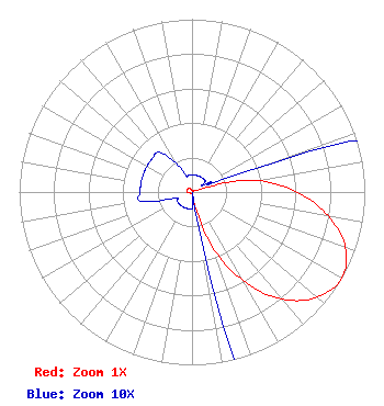 | ||||||||||||||||||
| Azimuth | Ratio | Azimuth | Ratio | Azimuth | Ratio | Azimuth | Ratio | ||||||||||||
| 0 | 0.010 | 10 | 0.010 | 20 | 0.010 | 30 | 0.010 | ||||||||||||
| 40 | 0.010 | 50 | 0.010 | 60 | 0.010 | 70 | 0.050 | ||||||||||||
| 80 | 0.380 | 90 | 0.606 | 100 | 0.800 | 110 | 0.945 | ||||||||||||
| 120 | 1.000 | 130 | 0.945 | 140 | 0.810 | 150 | 0.590 | ||||||||||||
| 160 | 0.325 | 170 | 0.010 | 180 | 0.010 | 190 | 0.010 | ||||||||||||
| 200 | 0.010 | 210 | 0.010 | 220 | 0.010 | 230 | 0.010 | ||||||||||||
| 240 | 0.010 | 250 | 0.010 | 260 | 0.030 | 270 | 0.030 | ||||||||||||
| 280 | 0.030 | 290 | 0.030 | 300 | 0.030 | 310 | 0.030 | ||||||||||||
| 320 | 0.030 | 330 | 0.020 | 340 | 0.010 | 350 | 0.010 | ||||||||||||
Structure Registration Number 1235667 Structure Type: GTOWER Registered To: County of San Bernardino, California Structure Address: 1.5 Miles Ne Of Newberry Springs Ca Newberry Springs, CA County Name: San Bernardino County ASR Issued: 06/24/2014 Date Built: 09/12/2003 Site Elevation: 560.2 m (1838 ft.) Structure Height: 65.5 m (215 ft.) Height Overall: 65.5 m (215 ft.) Overall Height AMSL: 625.7 m (2053 ft.) FAA Determination: 11/05/2013 FAA Study #: 2013-AWP-5480-OE FAA Circular #: 70/7460-1K Paint & Light FAA Chapters: 3, 4, 5, 12 OM&L to remain the same as prior study = PAINT/RED LIGHTS 34-50-02.3 N 116-40-52.8 W (NAD 83) 34-50-02.3 N 116-40-49.7 W (Converted to NAD 27) |
222 West Hospitality Lane, 2nd Floor San Bernardino, CA 92415 Phone: 909-386-8800 Applicant | Title: Area Manager Date: 09/01/2015 Application Certifier COUNTY OF SAN BERNARDINO AREA 40 County Of San Bernardino Area 40 157 West 5th Street, 2nd Floor San Bernardino, CA 92415 Applicant MICHAEL COUZENS Michael Couzens Law Office Oakland, CA 94609 REESE TROUBLEFIELD County Of San Bernardino, California Dept Of Special Districts 157 W Fifth Street 2nd Floor San Bernardino, CA 94215 AREA MANAGER | |||||||||||||||||