
FCCInfo.com
A Service of Cavell, Mertz & Associates, Inc.
(855) FCC-INFO
|
|
KJRH-TV from 07/14/1980 |
Virtual Channel 2 |
|
||||||||||||||||||||||||||||||||||||||||||||||
|
|
Repacking Information: No changes Status: License Application Accepted: 08/25/2016 License Expires: 06/01/2022 File Number: -0000013850 FCC Website Links: LMS Facility Details This Application Other KJRH-TV Applications Including Superseded Applications Mailing Address Correspondence for KJRH-TV Correspondence related to application -0000013850 Service Contour - Open Street Map or USGS Map (36 dBu) Service Contour - KML / Google Earth (36 dBu) Public Inspection Files History Cards for KJRH-TV Rabbit Ears Info Search for KJRH-TV Site Location: 36-01-15.0 N 95-40-33.0 W (NAD 83) Site Location: 36-01-14.6 N 95-40-32.1 W (Converted to NAD 27) ERP: 24 kW Polarization: Horizontally polarized HAAT: 504 m (1654 ft.) R/C AGL: 481 m (1578 ft.) R/C AMSL: 697.4 m (2288 ft.) Site Elevation: 216.4 m. (710 ft.) Height Overall*: 560.5 m (1839 ft.) (* As Filed In This Application, may differ from ASR Data, Below.) Directional Antenna - Antenna Make/Model: DIELECTRIC TLS-V4 Antenna ID: 110429 Polarization: Horizontally polarized | ||||||||||||||||||||||||||||||||||||||||||||||||
| Antenna Data for Antenna Id: 110429 KJRH-TV DX File: -0000013850 DIELECTRIC - TLS-V4 Service: DX Standard Pattern: Y | 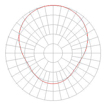 | ||||||||||||||||||||||||||||||||||||||||||||||||
| Azimuth | Ratio | Azimuth | Ratio | Azimuth | Ratio | Azimuth | Ratio | ||||||||||||||||||||||||||||||||||||||||||
| 0 | 1.000 | 10 | 0.996 | 20 | 0.981 | 30 | 0.955 | ||||||||||||||||||||||||||||||||||||||||||
| 40 | 0.920 | 50 | 0.876 | 60 | 0.826 | 70 | 0.771 | ||||||||||||||||||||||||||||||||||||||||||
| 80 | 0.714 | 90 | 0.661 | 100 | 0.615 | 110 | 0.583 | ||||||||||||||||||||||||||||||||||||||||||
| 120 | 0.569 | 130 | 0.571 | 140 | 0.586 | 150 | 0.607 | ||||||||||||||||||||||||||||||||||||||||||
| 160 | 0.627 | 170 | 0.640 | 180 | 0.645 | 190 | 0.641 | ||||||||||||||||||||||||||||||||||||||||||
| 200 | 0.631 | 210 | 0.613 | 220 | 0.592 | 230 | 0.579 | ||||||||||||||||||||||||||||||||||||||||||
| 240 | 0.570 | 250 | 0.579 | 260 | 0.610 | 270 | 0.650 | ||||||||||||||||||||||||||||||||||||||||||
| 280 | 0.699 | 290 | 0.759 | 300 | 0.817 | 310 | 0.869 | ||||||||||||||||||||||||||||||||||||||||||
| 320 | 0.914 | 330 | 0.951 | 340 | 0.975 | 350 | 0.993 | ||||||||||||||||||||||||||||||||||||||||||
Structure Registration Number 1011355 Structure Type: TOWER Registered To: TULSA TOWER JOINT VENTURE Structure Address: 101st & 273rd E Ave Oneta, OK County Name: Wagoner County ASR Issued: 10/07/2022 Date Built: 09/01/1984 Site Elevation: 216.4 m (710 ft.) Structure Height: 560.5 m (1839 ft.) Height Overall: 560.5 m (1839 ft.) Overall Height AMSL: 776.9 m (2549 ft.) FAA Determination: 03/16/1978 FAA Study #: 77-ASW-856-OE Paint & Light FAA Chapters: A1, B, G, H HIGH INTENSITY WHITE LIGHTS 36-01-15.0 N 95-40-33.0 W (NAD 83) 36-01-14.6 N 95-40-32.1 W (Converted to NAD 27) |
312 Walnut Street 28th Floor Cincinnati, OH 45202 Phone: 513-977-3000 Corporation | Title: Vice President/engineering Date: 08/25/2016 Application Certifier SCRIPPS MEDIA, INC. Scripps Media, Inc. 312 Walnut Street 28th Floor Cincinnati, OH 45202 Applicant KENNETH C. HOWARD, JR Baker & Hostetler Llp 1050 Connecticut Avenue, Nw Suite 1100 Washington, DC 20036 BENJAMIN PIDEK, P.E. Mid-state Consultants Lennon, MI 48449 CONSULTING ENGINEER | |||||||||||||||||||||||||||||||||||||||||||||||
|
| ||||||||||||||||||||||||||||||||||||||||||||||||