
FCCInfo.com
A Service of Cavell, Mertz & Associates, Inc.
(855) FCC-INFO
|
|
WPRQ-LD from 10/13/1998 WPRQ-LD from 06/13/1996 |
|
|
||||||||||||||||
|
|
Status: License Application Accepted: 10/07/2019 License Expires: 06/01/2021 File Number: -0000084343 FCC Website Links: LMS Facility Details This Application Other WPRQ-LD Applications Including Superseded Applications Mailing Address Correspondence for WPRQ-LD Correspondence related to application -0000084343 Service Contour - Open Street Map or USGS Map (48 dBu) Service Contour - KML / Google Earth (48 dBu) Rabbit Ears Info Search for WPRQ-LD Site Location: 34-10-43.2 N 90-33-02.9 W (NAD 83) Site Location: 34-10-42.8 N 90-33-02.5 W (Converted to NAD 27) ERP: 3 kW Polarization: Horizontally polarized R/C AGL: 96 m (315 ft.) R/C AMSL: 145.3 m (477 ft.) Emission Mask: Stringent Site Elevation: 49.3 m. (162 ft.) Height Overall*: 99 m (325 ft.) (* As Filed In This Application, may differ from ASR Data, Below.) Directional Antenna - Antenna Make/Model: Propagation System Inc PSIVLP2OI Antenna ID: 1005662 Polarization: Horizontally polarized | ||||||||||||||||||
| Antenna Data for Antenna Id: 1005662 WPRQ-LD LD File: -0000084343 Propagation System Inc - PSIVLP2OI Service: LD Standard Pattern: N Pattern and Field Values Include a 245° Clockwise Rotation | 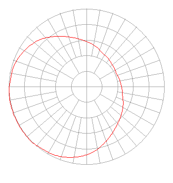 | ||||||||||||||||||
| Azimuth | Ratio | Azimuth | Ratio | Azimuth | Ratio | Azimuth | Ratio | ||||||||||||
| 5 | 0.560 | 15 | 0.520 | 25 | 0.480 | 35 | 0.460 | ||||||||||||
| 45 | 0.440 | 55 | 0.430 | 65 | 0.420 | 75 | 0.430 | ||||||||||||
| 85 | 0.440 | 95 | 0.460 | 105 | 0.480 | 115 | 0.520 | ||||||||||||
| 125 | 0.560 | 135 | 0.600 | 145 | 0.650 | 155 | 0.710 | ||||||||||||
| 165 | 0.780 | 175 | 0.850 | 185 | 0.900 | 195 | 0.940 | ||||||||||||
| 205 | 0.970 | 215 | 0.980 | 225 | 1.000 | 235 | 1.000 | ||||||||||||
| 245 | 1.000 | 255 | 1.000 | 265 | 1.000 | 275 | 0.980 | ||||||||||||
| 285 | 0.970 | 295 | 0.940 | 305 | 0.900 | 315 | 0.850 | ||||||||||||
| 325 | 0.780 | 335 | 0.710 | 345 | 0.650 | 355 | 0.600 | ||||||||||||
Structure Registration Number 1220441 [ASR Heights Differ from WPRQ-LD Application] Structure Type: LTOWER Registered To: American Towers LLC Structure Address: 115 Eddie C Smith Dr. (372599) Clarksdale, MS County Name: Coahoma County ASR Issued: 08/10/2023 Date Built: 02/20/2001 Site Elevation: 49.4 m (162 ft.) Structure Height: 92.7 m (304 ft.) Height Overall: 93.9 m (308 ft.) Overall Height AMSL: 143.3 m (470 ft.) FAA Determination: 08/08/2023 FAA Study #: 2023-ASO-8796-OE FAA Circular #: 70/7460-1K Paint & Light FAA Chapters: 4, 8, 12 OM&L to remain the same as prior study = A MED-DUAL SYSTEM 34-10-43.2 N 90-33-03.0 W (NAD 83) 34-10-42.8 N 90-33-02.6 W (Converted to NAD 27) |
Phone: 662-375-2654 Individual | Title: Owner Date: 10/07/2019 Application Certifier DAVID ELLINGTON Webb, MS 38966 Applicant DAVID Ellington Wprq Webb, MS 38966 Owner Richard C Goetz R & L Media Systems 135 N Country Club Dr Hendersonville, TN 37075 Broadcast Consultant | |||||||||||||||||