
FCCInfo.com
A Service of Cavell, Mertz & Associates, Inc.
(855) FCC-INFO
|
|
DWDLP-CD from 08/11/2011 DWDLP-CD from 05/15/2003 DWDLP-CD from 04/04/2003 DWDLP-CD from 12/20/1994 DWDLP-CD from 06/16/1994 DWDLP-CD from 07/09/1992 |
RF spectrum relinquished in the spectrum auction |
|
||||||||||||||||
|
|
Repacking Information: Channel 21 was relinquished in the spectrum auction Status: License Application Accepted: 06/05/2017 License Expires: 02/01/2021 File Number: -0000024790 FCC Website Links: LMS Facility Details This Application Other DWDLP-CD Applications Including Superseded Applications Mailing Address Correspondence for DWDLP-CD Correspondence related to application -0000024790 Service Contour - Open Street Map or USGS Map (51 dBu) Service Contour - KML / Google Earth (51 dBu) Public Inspection Files Rabbit Ears Info Search for DWDLP-CD Site Location: 25-59-10.0 N 80-11-36.3 W (NAD 83) Site Location: 25-59-08.7 N 80-11-37.1 W (Converted to NAD 27) ERP: 15 kW Electrical Beam Tilt: 0.75 degrees R/C AGL: 243.8 m (800 ft.) R/C AMSL: 247.2 m (811 ft.) Emission Mask: Stringent Site Elevation: 3.4 m. (11 ft.) Height Overall*: 310.6 m (1019 ft.) (* As Filed In This Application, may differ from ASR Data, Below.) Directional Antenna - Antenna Make/Model: RF TECHNOLOGIES CORP. CS2030CP-22PN/21 Antenna ID: 101098 | ||||||||||||||||||
| Antenna Data for Antenna Id: 101098 DWDLP-CD DC File: -0000024790 RF TECHNOLOGIES CORP. - CS2030CP-22PN/21 Service: DC Standard Pattern: Y Pattern and Field Values Include a 25° Clockwise Rotation | 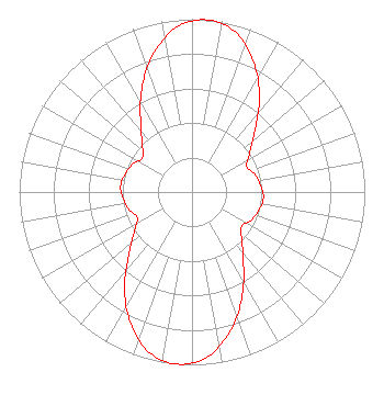 | ||||||||||||||||||
| Azimuth | Ratio | Azimuth | Ratio | Azimuth | Ratio | Azimuth | Ratio | ||||||||||||
| 5 | 1.000 | 15 | 0.960 | 25 | 0.840 | 35 | 0.680 | ||||||||||||
| 45 | 0.520 | 55 | 0.410 | 65 | 0.350 | 75 | 0.380 | ||||||||||||
| 85 | 0.400 | 95 | 0.415 | 105 | 0.400 | 115 | 0.380 | ||||||||||||
| 125 | 0.350 | 135 | 0.410 | 145 | 0.520 | 155 | 0.680 | ||||||||||||
| 165 | 0.840 | 175 | 0.960 | 185 | 1.000 | 195 | 0.960 | ||||||||||||
| 205 | 0.840 | 215 | 0.680 | 225 | 0.520 | 235 | 0.410 | ||||||||||||
| 245 | 0.350 | 255 | 0.380 | 265 | 0.400 | 275 | 0.415 | ||||||||||||
| 285 | 0.400 | 295 | 0.380 | 305 | 0.350 | 315 | 0.410 | ||||||||||||
| 325 | 0.520 | 335 | 0.680 | 345 | 0.840 | 355 | 0.960 | ||||||||||||
Structure Registration Number 1224225 Structure Type: GTOWER Registered To: American Towers LLC Structure Address: 4991 Sw 28th St (#23665) Hollywood, FL County Name: Broward County ASR Issued: 09/22/2023 Date Built: 10/12/2001 Site Elevation: 3.4 m (11 ft.) Structure Height: 287.4 m (943 ft.) Height Overall: 310.6 m (1019 ft.) Overall Height AMSL: 314 m (1030 ft.) FAA Determination: 09/20/2023 FAA Study #: 2022-ASO-44942-OE FAA Circular #: 70/7460-1M Paint & Light FAA Chapters: 4, 9, 15 PRIOR STUDY 2013-ASO-4030-OE 25-59-10.0 N 80-11-36.3 W (NAD 83) 25-59-08.7 N 80-11-37.1 W (Converted to NAD 27) |
C/o Brooks, Pierce Et Al. P.o. Box 1800 Raleigh, NC 27602 Phone: 919-839-0300 Limited Liability Company | Title: President Date: 06/05/2017 Application Certifier MAPALE LLC Mapale Llc C/o Brooks, Pierce Et Al. P.o. Box 1800 Raleigh, NC 27602 Applicant Stephen Hartzell Brooks, Pierce Et Al. 150 Fayetteville Street Suite 1700 Raleigh, NC 27601 | |||||||||||||||||