
FCCInfo.com
A Service of Cavell, Mertz & Associates, Inc.
(855) FCC-INFO
|
|
WGTW-TV from 07/14/1988 |
RF spectrum relinquished in the spectrum auction Virtual Channel 48 |  |
|
|||||||||||||||
|
|
WGTW-TV is a channel sharing guest of WMGM-TV, Wildwood, New Jersey Repacking Information: Channel 27 was relinquished in the spectrum auction Status: Construction Permit Application Accepted: 09/22/2017 WGTW-TV CP Expires: 02/01/2018 File Number: -0000026792 FCC Website Links: LMS Facility Details This Application Other WGTW-TV Applications Including Superseded Applications Mailing Address Correspondence for WGTW-TV Correspondence related to application -0000026792 Service Contour - Open Street Map or USGS Map (41 dBu) Service Contour - KML / Google Earth (41 dBu) Public Inspection Files Rabbit Ears Info Search for WGTW-TV Site Location: 39-07-28.3 N 74-45-54.5 W (NAD 83) Site Location: 39-07-27.9 N 74-45-55.9 W (Converted to NAD 27) ERP: 205 kW Polarization: Horizontally polarized HAAT: 126.5 m (415 ft.) Electrical Beam Tilt: 0.6 degrees R/C AGL: 127.1 m (417 ft.) R/C AMSL: 130.1 m (427 ft.) Site Elevation: 3 m. (10 ft.) Height Overall*: 134.1 m (440 ft.) (* As Filed In This Application, may differ from ASR Data, Below.) Directional Antenna - Antenna Make/Model: Electronics Research Inc. ATW18H3-HTC1-36S Antenna ID: 70520 Polarization: Horizontally polarized | ||||||||||||||||||
| Antenna Data for Antenna Id: 70520 WGTW-TV DT File: -0000026792 Electronics Research Inc. - ATW18H3-HTC1-36S Service: DT Standard Pattern: Y | 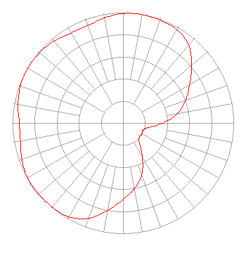 | ||||||||||||||||||
| Azimuth | Ratio | Azimuth | Ratio | Azimuth | Ratio | Azimuth | Ratio | ||||||||||||
| 0 | 0.989 | 10 | 0.994 | 20 | 0.987 | 30 | 0.974 | ||||||||||||
| 40 | 0.921 | 50 | 0.811 | 60 | 0.695 | 70 | 0.604 | ||||||||||||
| 80 | 0.504 | 90 | 0.363 | 100 | 0.235 | 110 | 0.190 | ||||||||||||
| 120 | 0.195 | 130 | 0.193 | 140 | 0.228 | 150 | 0.348 | ||||||||||||
| 160 | 0.495 | 170 | 0.602 | 180 | 0.691 | 190 | 0.803 | ||||||||||||
| 200 | 0.917 | 210 | 0.979 | 220 | 0.993 | 230 | 0.999 | ||||||||||||
| 234 | 1.000 | 240 | 0.996 | 250 | 0.972 | 260 | 0.941 | ||||||||||||
| 270 | 0.937 | 280 | 0.963 | 290 | 0.985 | 300 | 0.992 | ||||||||||||
| 310 | 0.987 | 320 | 0.966 | 330 | 0.938 | 340 | 0.935 | ||||||||||||
| 350 | 0.963 | ||||||||||||||||||
Structure Registration Number 1046230 Structure Type: GTOWER Registered To: SBA Towers V, LLC Structure Address: 226 Avalon Blvd (nj15439-a) Swainton, NJ County Name: Cape May County ASR Issued: 04/11/2017 Date Built: 07/09/2007 Site Elevation: 3 m (10 ft.) Structure Height: 122.5 m (402 ft.) Height Overall: 134.1 m (440 ft.) Overall Height AMSL: 137.1 m (450 ft.) FAA Determination: 04/07/2017 FAA Study #: 2017-AEA-3519-OE FAA Circular #: 70/7460-1L Paint & Light FAA Chapters: 4, 8, 12 PRIOR STUDY 2013-AEA-4490-OE 39-07-28.3 N 74-45-54.5 W (NAD 83) 39-07-27.9 N 74-45-55.9 W (Converted to NAD 27) |
13600 Heritage Parkway Suite 200 Fort Worth, TX 76177 Phone: 855-826-2255 Not-for-Profit | Title: Assistant Secretary Date: 09/22/2017 Application Certifier TRINITY BROADCASTING NETWORK Trinity Christian Center Of Santa Ana, Inc. P. O. Box C-11949 Santa Ana, CA 92711 Applicant Colby M. May, Esq. Colby M. May, Esq., P.c. P. O. Box 15473 Washington, DC 20003 Attorney Kevin T. Fisher Smith & Fisher 4791 Wintergreen Court Woodbridge, VA 22192 Broadcast Consultant | |||||||||||||||||