
FCCInfo.com
A Service of Cavell, Mertz & Associates, Inc.
(855) FCC-INFO
|
|
WMKG-CD from 09/08/1995 WMKG-CD from 09/20/1989 |
Post-repack Channel 31 |  |
|
|||||||||||||||
|
|
Repacking Information: Pre-Repack Channel: 49 Post-Repack Channel: 31 Post-Repack ERP: 10.6 kW Phase: 6 Completion Deadline: 10/18/2019 Find nearby TV Facilities Status: STA – Special Temporary Authority Application Accepted: 12/07/2017 STA Expires: 10/01/2021 File Number: -0000036087 FCC Website Links: LMS Facility Details This Application Other WMKG-CD Applications Including Superseded Applications Mailing Address Correspondence for WMKG-CD Correspondence related to application -0000036087 Service Contour - Open Street Map or USGS Map (51 dBu) Service Contour - KML / Google Earth (51 dBu) Public Inspection Files Rabbit Ears Info Search for WMKG-CD Site Location: 43-10-33.1 N 86-12-43.2 W (NAD 83) Site Location: 43-10-33.0 N 86-12-43.0 W (Converted to NAD 27) ERP: 15 kW Polarization: Horizontally polarized Electrical Beam Tilt: 1.75 degrees R/C AGL: 30 m (98 ft.) R/C AMSL: 221.4 m (726 ft.) Emission Mask: Stringent Site Elevation: 191.4 m. (628 ft.) Height Overall*: 33.5 m (110 ft.) (* As Filed In This Application, may differ from ASR Data, Below.) Directional Antenna - Antenna Make/Model: Andrew AL8 Antenna ID: 16352 Polarization: Horizontally polarized | ||||||||||||||||||
| Antenna Data for Antenna Id: 16352 WMKG-CD DC File: -0000036087 Andrew - AL8 Service: DC Standard Pattern: Y Pattern and Field Values Include a 60° Clockwise Rotation | 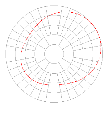 | ||||||||||||||||||
| Azimuth | Ratio | Azimuth | Ratio | Azimuth | Ratio | Azimuth | Ratio | ||||||||||||
| 0 | 0.829 | 10 | 0.876 | 20 | 0.918 | 30 | 0.953 | ||||||||||||
| 40 | 0.979 | 50 | 0.995 | 60 | 1.000 | 70 | 0.995 | ||||||||||||
| 80 | 0.979 | 90 | 0.953 | 100 | 0.918 | 110 | 0.876 | ||||||||||||
| 120 | 0.829 | 130 | 0.780 | 140 | 0.733 | 150 | 0.692 | ||||||||||||
| 160 | 0.662 | 170 | 0.644 | 180 | 0.639 | 190 | 0.646 | ||||||||||||
| 200 | 0.661 | 210 | 0.678 | 220 | 0.694 | 230 | 0.705 | ||||||||||||
| 240 | 0.709 | 250 | 0.705 | 260 | 0.694 | 270 | 0.678 | ||||||||||||
| 280 | 0.661 | 290 | 0.646 | 300 | 0.639 | 310 | 0.644 | ||||||||||||
| 320 | 0.662 | 330 | 0.692 | 340 | 0.733 | 350 | 0.780 | ||||||||||||
Structure Registration Number 1230898 Structure Type: TOWER Registered To: WMKG-TV, LLC Structure Address: 4237 Airline Drive Norton Shores, MI County Name: Muskegon County ASR Issued: 05/23/2017 Site Elevation: 191.4 m (628 ft.) Structure Height: 33.5 m (110 ft.) Height Overall: 33.5 m (110 ft.) Overall Height AMSL: 224.9 m (738 ft.) FAA Determination: 09/17/2001 FAA Study #: 01-AGL-6408-OE FAA Circular #: Paint & Light FAA Chapters: NONE PRIOR STUDY 92-AGL-1013-OE 43-10-33.1 N 86-12-43.2 W (NAD 83) 43-10-33.0 N 86-12-43.0 W (Converted to NAD 27) |
4237 Airline Road Norton Shores, MI 49441 Phone: 231-246-2165 Limited Liability Company | Title: Attorney Date: 12/07/2017 Application Certifier Wmkg-tv, Llc 4237 Airline Road Norton Shores, MI 49441 Applicant Richard C Goetz R & L Media Systems 135 N Country Club Dr Hendersonville, TN 37075 Broadcast Consultant JAMES A. Koerner, Esq. Koerner & Olender, P.c. 7020 Richard Drive Bethesda, MD 20817 Attorney | |||||||||||||||||
| |||||||||||||||||||