
FCCInfo.com
A Service of Cavell, Mertz & Associates, Inc.
(855) FCC-INFO
|
|
|
|
|
||||||||||||||||
|
|
Status: License Application Accepted: 03/12/2018 License Expires: 12/01/2022 File Number: -0000048526 FCC Website Links: LMS Facility Details This Application Other KZSW-LD Applications Including Superseded Applications Mailing Address Correspondence for KZSW-LD Correspondence related to application -0000048526 Service Contour - Open Street Map or USGS Map (48 dBu) Service Contour - KML / Google Earth (48 dBu) Rabbit Ears Info Search for KZSW-LD Site Location: 33-57-38.0 N 117-16-46.0 W (NAD 83) Site Location: 33-57-37.9 N 117-16-42.9 W (Converted to NAD 27) ERP: 3 kW Polarization: Horizontally polarized R/C AGL: 30.5 m (100 ft.) R/C AMSL: 959.2 m (3147 ft.) Emission Mask: Full Service Site Elevation: 928.7 m. (3047 ft.) Height Overall*: 43 m (141 ft.) (* As Filed In This Application, may differ from ASR Data, Below.) Directional Antenna - Antenna Make/Model: KATHREIN HDCA-10 Antenna ID: 1001235 Polarization: Horizontally polarized | ||||||||||||||||||
| Antenna Data for Antenna Id: 1001235 KZSW-LD LD File: -0000048526 KATHREIN - HDCA-10 Service: LD Standard Pattern: Y Pattern and Field Values Include a 85° Clockwise Rotation | 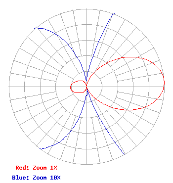 | ||||||||||||||||||
| Azimuth | Ratio | Azimuth | Ratio | Azimuth | Ratio | Azimuth | Ratio | ||||||||||||
| 5 | 0.015 | 15 | 0.058 | 25 | 0.152 | 35 | 0.295 | ||||||||||||
| 45 | 0.472 | 55 | 0.660 | 65 | 0.830 | 75 | 0.950 | ||||||||||||
| 85 | 1.000 | 95 | 0.968 | 105 | 0.860 | 115 | 0.694 | ||||||||||||
| 125 | 0.504 | 135 | 0.319 | 145 | 0.169 | 155 | 0.062 | ||||||||||||
| 165 | 0.007 | 175 | 0.011 | 185 | 0.015 | 195 | 0.047 | ||||||||||||
| 205 | 0.077 | 215 | 0.097 | 225 | 0.116 | 235 | 0.142 | ||||||||||||
| 245 | 0.172 | 255 | 0.196 | 265 | 0.207 | 275 | 0.199 | ||||||||||||
| 285 | 0.175 | 295 | 0.149 | 305 | 0.126 | 315 | 0.106 | ||||||||||||
| 325 | 0.089 | 335 | 0.063 | 345 | 0.031 | 355 | 0.009 | ||||||||||||
Structure Registration Number 1031514 Structure Type: TOWER Registered To: WIRELESS SITES, INC. Structure Address: Box Springs Mountain Riverside, CA County Name: Riverside County ASR Issued: 01/05/1998 Date Built: 07/30/1970 Site Elevation: 928.7 m (3047 ft.) Structure Height: 43 m (141 ft.) Height Overall: 43 m (141 ft.) Overall Height AMSL: 971.7 m (3188 ft.) FAA Determination: 11/25/1997 FAA Study #: 97-AWP-2670-OE Paint & Light FAA Chapters: NONE Removed expiration date from determination. Scenario 1./jjs/case#635066 33-57-38.0 N 117-16-46.0 W (NAD 83) 33-57-37.9 N 117-16-42.9 W (Converted to NAD 27) |
Po Box 220 West Frankfort, IL 62896 Phone: 618-267-4651 Not-for-Profit | Title: President Date: 03/12/2018 Application Certifier 3ABN Three Angels Broadcasting Network Po Box 220 West Frankfort, IL 62896 Applicant Greg Best Greg Best Consulting 16100 Outlook Avenue Stilwell, KS 66085 President | |||||||||||||||||