
FCCInfo.com
A Service of Cavell, Mertz & Associates, Inc.
(855) FCC-INFO
|
|
KNWS-LD from 02/03/2021 KNWS-LD from 01/06/2011 KNWS-LD from 06/28/2004 KNWS-LD from 11/20/1997 |
|
|
||||||||||||||||
|
|
Status: STA – Special Temporary Authority Application Accepted: 05/23/2018 STA Expires: 00/00/0000 File Number: -0000054365 FCC Website Links: LMS Facility Details This Application Other KNWS-LD Applications Including Superseded Applications Mailing Address Correspondence for KNWS-LD Correspondence related to application -0000054365 Service Contour - Open Street Map or USGS Map (74 dBu) Service Contour - KML / Google Earth (74 dBu) Rabbit Ears Info Search for KNWS-LD Site Location: 26-09-01.5 N 97-30-58.7 W (NAD 83) Site Location: 26-09-00.2 N 97-30-57.8 W (Converted to NAD 27) ERP: 1.5 kW Polarization: Horizontally polarized R/C AGL: 30.5 m (100 ft.) R/C AMSL: 36.6 m (120 ft.) Site Elevation: 6.1 m. (20 ft.) Height Overall*: 97.5 m (320 ft.) (* As Filed In This Application, may differ from ASR Data, Below.) Directional Antenna - Antenna Make/Model: Kathrein K723147 Antenna ID: 117261 Polarization: Horizontally polarized | ||||||||||||||||||
| Antenna Data for Antenna Id: 117261 KNWS-LD TX File: -0000054365 Kathrein - K723147 Service: TX Standard Pattern: Y Pattern and Field Values Include a 170° Clockwise Rotation | 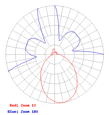 | ||||||||||||||||||
| Azimuth | Ratio | Azimuth | Ratio | Azimuth | Ratio | Azimuth | Ratio | ||||||||||||
| 0 | 0.100 | 10 | 0.050 | 20 | 0.030 | 30 | 0.050 | ||||||||||||
| 40 | 0.060 | 50 | 0.060 | 60 | 0.060 | 70 | 0.050 | ||||||||||||
| 80 | 0.040 | 90 | 0.100 | 100 | 0.160 | 110 | 0.280 | ||||||||||||
| 120 | 0.420 | 130 | 0.560 | 140 | 0.720 | 150 | 0.870 | ||||||||||||
| 160 | 0.960 | 170 | 1.000 | 180 | 0.960 | 190 | 0.870 | ||||||||||||
| 200 | 0.720 | 210 | 0.560 | 220 | 0.420 | 230 | 0.280 | ||||||||||||
| 240 | 0.160 | 250 | 0.100 | 260 | 0.040 | 270 | 0.050 | ||||||||||||
| 280 | 0.060 | 290 | 0.060 | 300 | 0.060 | 310 | 0.050 | ||||||||||||
| 320 | 0.030 | 330 | 0.050 | 340 | 0.100 | 350 | 0.110 | ||||||||||||
Structure Registration Number 1214446 Structure Type: TOWER Registered To: American Towers LLC Structure Address: 28612 Fm 803 (035845) San Benito, TX County Name: Cameron County ASR Issued: 06/24/2016 Date Built: 08/16/2000 Site Elevation: 6.1 m (20 ft.) Structure Height: 92.7 m (304 ft.) Height Overall: 97.5 m (320 ft.) Overall Height AMSL: 103.6 m (340 ft.) FAA Determination: 11/23/2010 FAA Study #: 2010-ASW-6404-OE FAA Circular #: 70/7460-1K Paint & Light FAA Chapters: 4, 8, 12 PRIOR STUDY 2010-ASW-5758-OE 26-09-01.5 N 97-30-58.7 W (NAD 83) 26-09-00.2 N 97-30-57.8 W (Converted to NAD 27) |
295 Madison Avenue, 12th Floor New York, NY 10017 Phone: 954-606-5486 Corporation | Title: Chief Operating Officer Date: 05/23/2018 Application Certifier HC2 NETWORK INC. Hc2 Network Inc. 450 Park Avenue 30th Floor New York, NY 10022 Applicant Esq Jack N Goodman N Goodman, Esq Law Offices Of Jack N. Goodman 1200 New Hampshire Ave, Nw Washington, DC 20036 | |||||||||||||||||