
FCCInfo.com
A Service of Cavell, Mertz & Associates, Inc.
(855) FCC-INFO
|
|
K21MP-D from 04/10/2012 K21MP-D from 07/26/2011 K21MP-D from 03/10/2011 K21MP-D from 10/06/2000 K21MP-D from 11/21/1991 |
|
|
||||||||||||||||
|
|
Status: License Application Accepted: 06/06/2018 License Expires: 06/01/2022 File Number: -0000055044 FCC Website Links: LMS Facility Details This Application Other K21MP-D Applications Including Superseded Applications Mailing Address Correspondence for K21MP-D Correspondence related to application -0000055044 Service Contour - Open Street Map or USGS Map (51 dBu) Service Contour - KML / Google Earth (51 dBu) Rabbit Ears Info Search for K21MP-D Site Location: 34-36-27.0 N 98-16-27.0 W (NAD 83) Site Location: 34-36-26.7 N 98-16-25.8 W (Converted to NAD 27) ERP: 15 kW Polarization: Elliptically polarized R/C AGL: 145 m (476 ft.) R/C AMSL: 520 m (1706 ft.) Emission Mask: Full Service Site Elevation: 375 m. (1230 ft.) Height Overall*: 152 m (499 ft.) (* As Filed In This Application, may differ from ASR Data, Below.) Directional Antenna - Antenna Make/Model: Jampro JL-8 Antenna ID: 19610 Polarization: Elliptically polarized | ||||||||||||||||||
| Antenna Data for Antenna Id: 19610 K21MP-D LD File: -0000055044 Jampro - JL-8 Service: LD Standard Pattern: Y Pattern and Field Values Include a 280° Clockwise Rotation | 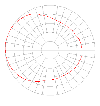 | ||||||||||||||||||
| Azimuth | Ratio | Azimuth | Ratio | Azimuth | Ratio | Azimuth | Ratio | ||||||||||||
| 0 | 0.730 | 10 | 0.680 | 20 | 0.660 | 30 | 0.650 | ||||||||||||
| 40 | 0.650 | 50 | 0.660 | 60 | 0.660 | 70 | 0.690 | ||||||||||||
| 80 | 0.700 | 90 | 0.710 | 100 | 0.720 | 110 | 0.700 | ||||||||||||
| 120 | 0.690 | 130 | 0.670 | 140 | 0.650 | 150 | 0.640 | ||||||||||||
| 160 | 0.640 | 170 | 0.650 | 180 | 0.660 | 190 | 0.680 | ||||||||||||
| 200 | 0.740 | 210 | 0.790 | 220 | 0.850 | 230 | 0.890 | ||||||||||||
| 240 | 0.930 | 250 | 0.960 | 260 | 0.980 | 270 | 0.990 | ||||||||||||
| 280 | 1.000 | 290 | 0.990 | 300 | 0.990 | 310 | 0.970 | ||||||||||||
| 320 | 0.940 | 330 | 0.910 | 340 | 0.850 | 350 | 0.780 | ||||||||||||
Structure Registration Number 1011804 Structure Type: TOWER Registered To: PATRICK, ARTHUR DBA = LAWTON COMMUNICATIONS Structure Address: 7 Mi E Hwy 7 To Trail Ridge Rd N 1 Mi W 2950' Lawton, OK County Name: Comanche County ASR Issued: 01/13/1997 Date Built: 07/01/1983 Site Elevation: 375 m (1230 ft.) Structure Height: 146 m (479 ft.) Height Overall: 152 m (499 ft.) Overall Height AMSL: 527 m (1729 ft.) FAA Determination: 03/30/1983 FAA Study #: 83-ASW-0459-OE FAA Circular #: 70/7460-1F Paint & Light FAA Chapters: 3, 4, 5, 9 34-36-27.0 N 98-16-27.0 W (NAD 83) 34-36-26.7 N 98-16-25.8 W (Converted to NAD 27) |
Po Box 220 West Frankfort, IL 62896 Phone: 618-627-4651 Not-for-Profit | Title: President Date: 06/06/2018 Application Certifier THREE ANGELS BROADCASTING NETWORK, INC. Three Angels Broadcasting Network, Inc. Po Box 220 West Frankfort, IL 62896 Applicant DANIEL N. PEEK 3abn Po Box 220 West Frankfort, IL 62896 ENGINEER MOSES PRIMO 3abn West Frankfort, IL 62896 DIRECTOR OF BROADCASTING OPERATIONS AND ENGINEERING | |||||||||||||||||