
FCCInfo.com
A Service of Cavell, Mertz & Associates, Inc.
(855) FCC-INFO
|
|
WNCR-LD from 06/12/2018 WNCR-LD from 07/14/2009 WNCR-LD from 11/08/2002 WNCR-LD from 08/23/1999 WNCR-LD from 03/15/1999 WNCR-LD from 07/21/1995 |
|
|
||||||||||||||||
|
|
Status: License Application Accepted: 06/07/2018 License Expires: 12/01/2020 File Number: -0000055079 FCC Website Links: LMS Facility Details This Application Other WNCR-LD Applications Including Superseded Applications Mailing Address Correspondence for WNCR-LD Correspondence related to application -0000055079 Service Contour - Open Street Map or USGS Map (51 dBu) Service Contour - KML / Google Earth (51 dBu) Rabbit Ears Info Search for WNCR-LD Site Location: 35-54-11.0 N 77-46-56.0 W (NAD 83) Site Location: 35-54-10.4 N 77-46-57.1 W (Converted to NAD 27) ERP: 15 kW Polarization: Horizontally polarized R/C AGL: 141.8 m (465 ft.) R/C AMSL: 182.9 m (600 ft.) Emission Mask: Full Service Site Elevation: 41.1 m. (135 ft.) Height Overall*: 152.4 m (500 ft.) (* As Filed In This Application, may differ from ASR Data, Below.) Directional Antenna - Antenna Make/Model: Aldena UP-6-C Antenna ID: 1003846 Polarization: Horizontally polarized | ||||||||||||||||||
| Antenna Data for Antenna Id: 1003846 WNCR-LD LD File: -0000055079 Aldena - UP-6-C Service: LD Standard Pattern: N | 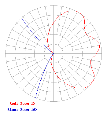 | ||||||||||||||||||
| Azimuth | Ratio | Azimuth | Ratio | Azimuth | Ratio | Azimuth | Ratio | ||||||||||||
| 0 | 0.636 | 10 | 0.803 | 20 | 0.937 | 30 | 1.000 | ||||||||||||
| 40 | 0.977 | 50 | 0.839 | 60 | 0.789 | 70 | 0.895 | ||||||||||||
| 80 | 0.969 | 90 | 0.895 | 100 | 0.789 | 110 | 0.839 | ||||||||||||
| 120 | 0.977 | 130 | 1.000 | 140 | 0.939 | 150 | 0.803 | ||||||||||||
| 160 | 0.636 | 170 | 0.485 | 180 | 0.348 | 190 | 0.237 | ||||||||||||
| 200 | 0.120 | 210 | 0.024 | 220 | 0.001 | 230 | 0.001 | ||||||||||||
| 240 | 0.001 | 250 | 0.001 | 260 | 0.001 | 270 | 0.001 | ||||||||||||
| 280 | 0.001 | 290 | 0.001 | 300 | 0.001 | 310 | 0.024 | ||||||||||||
| 320 | 0.120 | 330 | 0.237 | 340 | 0.348 | 350 | 0.485 | ||||||||||||
Structure Registration Number 1004420 Structure Type: TOWER Registered To: BROWNS GIFTS OF ROCKY MOUNT INC DBA = BROWN COMMUNICATION TOWERS Structure Address: Pleasant Hill Rd Rocky Mount, NC County Name: Edgecombe County ASR Issued: 10/25/1996 Date Built: 01/01/1995 Site Elevation: 41.1 m (135 ft.) Structure Height: 152.4 m (500 ft.) Height Overall: 152.4 m (500 ft.) Overall Height AMSL: 193.5 m (635 ft.) FAA Determination: 02/07/1995 FAA Study #: 94-ASO-3408-OE FAA Circular #: 70/7460-1H Paint & Light FAA Chapters: 3, 4, 5, 13 35-54-11.0 N 77-46-56.0 W (NAD 83) 35-54-10.4 N 77-46-57.1 W (Converted to NAD 27) |
P.o. Box 2003 Rocky Mount, NC 28702 Phone: 252-407-8365 Corporation | Title: President Date: 06/07/2018 Application Certifier ON THE MAP, INC. On The Map, Inc. 124 Menorca Island Ct. Las Vegas, NV 89138 Applicant Michelle A. McClure Fletcher, Heald & Hildreth, P.l.c. 1300 N. 17th St. 11th Floor Arlington, VA 22209 ATTORNEY W. JEFFREY REYNOLDS Dutreil, Lundin, And Rackley, Inc. 3135 Southgate Circle Sarasota, FL 34239 TECHNICAL CONSULTANT | |||||||||||||||||
| |||||||||||||||||||