
FCCInfo.com
A Service of Cavell, Mertz & Associates, Inc.
(855) FCC-INFO
|
|
K15LM-D from 11/15/2012 K15LM-D from 09/29/1993 |
|
|
||||||||||||||||
|
|
Status: License Application Accepted: 03/27/2019 License Expires: 06/01/2022 File Number: -0000068703 FCC Website Links: LMS Facility Details This Application Other K15LM-D Applications Including Superseded Applications Mailing Address Correspondence for K15LM-D Correspondence related to application -0000068703 Service Contour - Open Street Map or USGS Map (51 dBu) Service Contour - KML / Google Earth (51 dBu) Rabbit Ears Info Search for K15LM-D Site Location: 34-59-13.0 N 95-42-11.0 W (NAD 83) Site Location: 34-59-12.7 N 95-42-10.0 W (Converted to NAD 27) ERP: 0.4 kW Polarization: Horizontally polarized R/C AGL: 106.5 m (349 ft.) R/C AMSL: 361 m (1184 ft.) Emission Mask: Stringent Site Elevation: 254.5 m. (835 ft.) Height Overall*: 150.2 m (493 ft.) (* As Filed In This Application, may differ from ASR Data, Below.) Directional Antenna - Antenna Make/Model: Kathrein 770-881 Antenna ID: 109715 Polarization: Horizontally polarized
| ||||||||||||||||||
| Antenna Data for Antenna Id: 109715 K15LM-D LD File: -0000068703 Kathrein - 770-881 Service: LD Standard Pattern: Y Pattern and Field Values Include a 60° Clockwise Rotation | 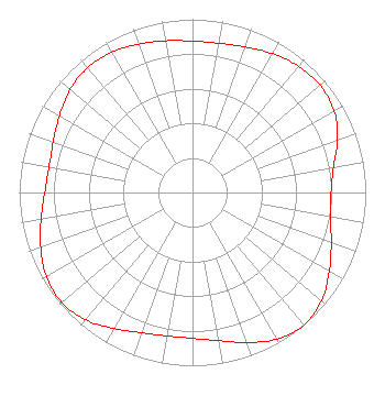 | ||||||||||||||||||
| Azimuth | Ratio | Azimuth | Ratio | Azimuth | Ratio | Azimuth | Ratio | ||||||||||||
| 0 | 0.874 | 10 | 0.875 | 20 | 0.894 | 30 | 0.924 | ||||||||||||
| 40 | 0.952 | 50 | 0.962 | 60 | 0.944 | 70 | 0.890 | ||||||||||||
| 80 | 0.827 | 90 | 0.799 | 100 | 0.808 | 110 | 0.852 | ||||||||||||
| 120 | 0.912 | 130 | 0.971 | 140 | 1.000 | 150 | 0.976 | ||||||||||||
| 160 | 0.922 | 170 | 0.868 | 180 | 0.842 | 190 | 0.841 | ||||||||||||
| 200 | 0.861 | 210 | 0.907 | 220 | 0.960 | 230 | 0.987 | ||||||||||||
| 240 | 0.973 | 250 | 0.932 | 260 | 0.888 | 270 | 0.853 | ||||||||||||
| 280 | 0.841 | 290 | 0.855 | 300 | 0.886 | 310 | 0.923 | ||||||||||||
| 320 | 0.941 | 330 | 0.934 | 340 | 0.912 | 350 | 0.889 | ||||||||||||
Structure Registration Number 1051571 Structure Type: TOWER Registered To: LITTLE DIXIE RADIO INC DBA = KMCO FM Structure Address: 2 Mile Lane Krebs, OK County Name: Pittsburg County ASR Issued: 06/30/1998 Site Elevation: 254.5 m (835 ft.) Structure Height: 150.2 m (493 ft.) Height Overall: 150.2 m (493 ft.) Overall Height AMSL: 404.7 m (1328 ft.) FAA Determination: 09/27/1996 FAA Study #: 96-ASW-2259-OE FAA Circular #: 70/7460-1J Paint & Light FAA Chapters: 3, 4, 5, 13 34-59-13.0 N 95-42-11.0 W (NAD 83) 34-59-12.7 N 95-42-10.0 W (Converted to NAD 27) |
100 W. Main Street Suite 100 Oklahoma City, OK 73102 Phone: 405-841-9106 Limited Liability Company | Title: Legal Counsel Date: 03/27/2019 Application Certifier OKLAHOMA COMMUNITY TELEVISION, LLC Oklahoma Community Television, Llc P.o. Box 398 Sayre, OK 73662 Applicant Jack Mills Oklahoma Community Television, L.l.c. 7401 N. Kelley Avenue Olkahoma City, OK 73111 ENGINEER David A O'Connor Wilkinson Barker Knauer, Llp Wilkinson Barker Knauer, Llp 1800 M Street, Nw, Suite 800n Washington, DC 20036 Partner | |||||||||||||||||