
FCCInfo.com
A Service of Cavell, Mertz & Associates, Inc.
(855) FCC-INFO
|
|
KFPX-TV from 08/24/1998 |
Post-repack Channel 36 Virtual Channel 39 |  |
|
|||||||||||||||
|
|
Repacking Information: Pre-Repack Channel: 39 Post-Repack Channel: 36 Post-Repack ERP: 109 kW Phase: 1 Completion Deadline: 11/30/2018 Find nearby TV Facilities Status: License Application Accepted: 11/09/2018 License Expires: 02/01/2022 File Number: -0000063434 FCC Website Links: LMS Facility Details This Application Other KFPX-TV Applications Including Superseded Applications Mailing Address Correspondence for KFPX-TV Correspondence related to application -0000063434 Service Contour - Open Street Map or USGS Map (41 dBu) Service Contour - KML / Google Earth (41 dBu) Public Inspection Files Rabbit Ears Info Search for KFPX-TV Site Location: 41-48-35.0 N 93-37-17.0 W (NAD 83) Site Location: 41-48-35.0 N 93-37-16.2 W (Converted to NAD 27) ERP: 270 kW Polarization: Elliptically polarized HAAT: 564 m (1850 ft.) Electrical Beam Tilt: 0.75 degrees R/C AGL: 559.9 m (1837 ft.) R/C AMSL: 855.6 m (2807 ft.) Site Elevation: 295.7 m. (970 ft.) Height Overall*: 609.6 m (2000 ft.) (* As Filed In This Application, may differ from ASR Data, Below.) Directional Antenna - Antenna Make/Model: DIELECTRIC TFU-20DSC/VP-R P230 Antenna ID: 1004321 Polarization: Elliptically polarized | ||||||||||||||||||
| Antenna Data for Antenna Id: 1004321 KFPX-TV DT File: -0000063434 DIELECTRIC - TFU-20DSC/VP-R P230 Service: DT Standard Pattern: N | 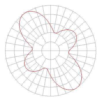 | ||||||||||||||||||
| Azimuth | Ratio | Azimuth | Ratio | Azimuth | Ratio | Azimuth | Ratio | ||||||||||||
| 0 | 0.552 | 10 | 0.418 | 20 | 0.413 | 30 | 0.504 | ||||||||||||
| 40 | 0.599 | 50 | 0.654 | 60 | 0.654 | 70 | 0.599 | ||||||||||||
| 80 | 0.504 | 90 | 0.413 | 100 | 0.418 | 110 | 0.552 | ||||||||||||
| 120 | 0.736 | 130 | 0.896 | 140 | 0.988 | 145 | 1.000 | ||||||||||||
| 150 | 0.988 | 160 | 0.896 | 170 | 0.736 | 180 | 0.552 | ||||||||||||
| 190 | 0.418 | 200 | 0.413 | 210 | 0.504 | 220 | 0.599 | ||||||||||||
| 230 | 0.654 | 240 | 0.654 | 250 | 0.599 | 260 | 0.504 | ||||||||||||
| 270 | 0.413 | 280 | 0.418 | 290 | 0.552 | 300 | 0.736 | ||||||||||||
| 310 | 0.896 | 320 | 0.988 | 325 | 1.000 | 330 | 0.988 | ||||||||||||
| 340 | 0.896 | 350 | 0.736 | ||||||||||||||||
Structure Registration Number 1016799 Structure Type: TOWER Registered To: Hearst Properties Inc. Structure Address: 310 Nw 134th Ave Alleman, IA County Name: Polk County ASR Issued: 11/22/2016 Date Built: 01/01/1974 Site Elevation: 295.7 m (970 ft.) Structure Height: 574 m (1883 ft.) Height Overall: 609.6 m (2000 ft.) Overall Height AMSL: 905.3 m (2970 ft.) FAA Determination: 07/20/1995 FAA Study #: 70-CE-592-OE FAA Circular #: 70/7460-1H Paint & Light FAA Chapters: 4, 7, 13 41-48-35.0 N 93-37-17.0 W (NAD 83) 41-48-35.0 N 93-37-16.2 W (Converted to NAD 27) |
312 Walnut Street 28th Floor Cincinnati, OH 45202 Phone: 513-977-3000 Limited Liability Company | Title: Vp, Engineering Date: 11/09/2018 Application Certifier ION TELEVISION LICENSE, LLC Ion Television License, Llc 601 Clearwater Park Road West Palm Beach, FL 33401 Applicant Shea Clark Ion Media Networks, Inc. 14444 66th Street N Clearwater, FL 33764 VP, Engineering Bianca Frye Ion Media Networks, Inc. 601 Clearwater Park Road West Palm Beach, FL 33401 | |||||||||||||||||