
FCCInfo.com
A Service of Cavell, Mertz & Associates, Inc.
(855) FCC-INFO
|
|
|
|
|
||||||||||||||||
|
|
Status: License Application Accepted: 07/30/2020 License Expires: 12/01/2020 File Number: -0000119377 FCC Website Links: LMS Facility Details This Application Other W15DY-D Applications Including Superseded Applications Mailing Address Correspondence for W15DY-D Correspondence related to application -0000119377 Service Contour - Open Street Map or USGS Map (51 dBu) Service Contour - KML / Google Earth (51 dBu) Rabbit Ears Info Search for W15DY-D Site Location: 35-40-16.7 N 82-00-18.7 W (NAD 83) Site Location: 35-40-16.3 N 82-00-19.3 W (Converted to NAD 27) ERP: 0.25 kW Polarization: Horizontally polarized Electrical Beam Tilt: 0.5 degrees R/C AGL: 20 m (66 ft.) R/C AMSL: 616.5 m (2023 ft.) Emission Mask: Simple Site Elevation: 596.5 m. (1957 ft.) Height Overall*: 24.4 m (80 ft.) (* As Filed In This Application, may differ from ASR Data, Below.) Directional Antenna - Antenna Make/Model: DIELECTRIC TLP-8B Antenna ID: 64167 Polarization: Horizontally polarized | ||||||||||||||||||
| Antenna Data for Antenna Id: 64167 W15DY-D LD File: -0000119377 DIELECTRIC - TLP-8B Service: LD Standard Pattern: Y Pattern and Field Values Include a 200.0° Clockwise Rotation | 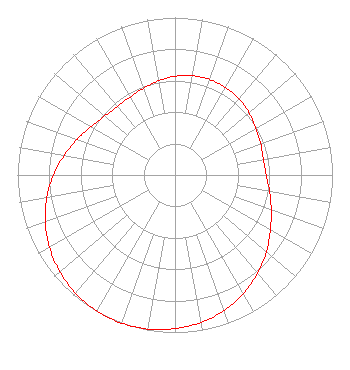 | ||||||||||||||||||
| Azimuth | Ratio | Azimuth | Ratio | Azimuth | Ratio | Azimuth | Ratio | ||||||||||||
| 0 | 0.627 | 10 | 0.640 | 20 | 0.645 | 30 | 0.641 | ||||||||||||
| 40 | 0.631 | 50 | 0.613 | 60 | 0.592 | 70 | 0.579 | ||||||||||||
| 80 | 0.570 | 90 | 0.579 | 100 | 0.610 | 110 | 0.650 | ||||||||||||
| 120 | 0.699 | 130 | 0.759 | 140 | 0.817 | 150 | 0.869 | ||||||||||||
| 160 | 0.914 | 170 | 0.951 | 180 | 0.975 | 190 | 0.993 | ||||||||||||
| 200 | 1.000 | 210 | 0.996 | 220 | 0.981 | 230 | 0.955 | ||||||||||||
| 240 | 0.920 | 250 | 0.876 | 260 | 0.826 | 270 | 0.771 | ||||||||||||
| 280 | 0.714 | 290 | 0.661 | 300 | 0.615 | 310 | 0.583 | ||||||||||||
| 320 | 0.569 | 330 | 0.571 | 340 | 0.586 | 350 | 0.607 | ||||||||||||
Structure Registration Number 1296368 Structure Type: GTOWER Registered To: WLOS Licensee, LLC Structure Address: East Glenview Street Marion, NC County Name: McDowell County ASR Issued: 01/11/2017 Date Built: 06/17/1988 Site Elevation: 596.5 m (1957 ft.) Structure Height: 24.4 m (80 ft.) Height Overall: 24.4 m (80 ft.) Overall Height AMSL: 620.9 m (2037 ft.) FAA Determination: 01/14/2015 FAA Study #: 2014-ASO-13835-OE Paint & Light FAA Chapters: NONE 35-40-16.7 N 82-00-18.7 W (NAD 83) 35-40-16.3 N 82-00-19.3 W (Converted to NAD 27) |
10706 Beaver Dam Road Cockeyesville, MD 21030 Phone: 410-568-1500 Limited Liability Company | Title: Cfo Date: 07/30/2020 Application Certifier WLOS LICENSEE, LLC Wlos Licensee, Llc 10706 Beaver Dam Road Cockeyesville, MD 21030 Applicant Jim McDonald B. W. St. Clair 2305 Vida Shaw Rd. New Iberia, LA 70563 Engineering Consultant Paul A Cicelski Lerman Senter, Pllc 2001 L St Nw Suite 400 Washington, DC 20036 Legal Counsel | |||||||||||||||||