
FCCInfo.com
A Service of Cavell, Mertz & Associates, Inc.
(855) FCC-INFO
|
|
KGKC-LD from 03/09/2009 KGKC-LD from 08/19/2005 |
|
|
||||||||||||||||
|
|
Status: License Application Accepted: 11/21/2018 License Expires: 06/01/2022 File Number: -0000063669 FCC Website Links: LMS Facility Details This Application Other KGKC-LD Applications Including Superseded Applications Mailing Address Correspondence for KGKC-LD Correspondence related to application -0000063669 Service Contour - Open Street Map or USGS Map (51 dBu) Service Contour - KML / Google Earth (51 dBu) Rabbit Ears Info Search for KGKC-LD Site Location: 39-01-19.9 N 94-30-49.7 W (NAD 83) Site Location: 39-01-19.9 N 94-30-48.9 W (Converted to NAD 27) ERP: 15 kW Polarization: Horizontally polarized Electrical Beam Tilt: 1 degree R/C AGL: 274 m (899 ft.) R/C AMSL: 544.1 m (1785 ft.) Emission Mask: Full Service Site Elevation: 270.1 m. (886 ft.) Height Overall*: 353 m (1158 ft.) (* As Filed In This Application, may differ from ASR Data, Below.) Directional Antenna - Antenna Make/Model: ATC ATC-BCH416UA-33 Antenna ID: 1004347 Polarization: Horizontally polarized | ||||||||||||||||||
| Antenna Data for Antenna Id: 1004347 KGKC-LD LD File: -0000063669 ATC - ATC-BCH416UA-33 Service: LD Standard Pattern: N Pattern and Field Values Include a 310° Clockwise Rotation | 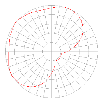 | ||||||||||||||||||
| Azimuth | Ratio | Azimuth | Ratio | Azimuth | Ratio | Azimuth | Ratio | ||||||||||||
| 0 | 0.940 | 10 | 0.975 | 20 | 1.000 | 30 | 0.980 | ||||||||||||
| 40 | 0.950 | 50 | 0.875 | 60 | 0.775 | 70 | 0.630 | ||||||||||||
| 80 | 0.470 | 90 | 0.350 | 100 | 0.230 | 110 | 0.220 | ||||||||||||
| 120 | 0.225 | 130 | 0.230 | 140 | 0.225 | 150 | 0.220 | ||||||||||||
| 160 | 0.230 | 170 | 0.350 | 180 | 0.470 | 190 | 0.630 | ||||||||||||
| 200 | 0.775 | 210 | 0.875 | 220 | 0.950 | 230 | 0.980 | ||||||||||||
| 240 | 1.000 | 250 | 0.975 | 260 | 0.940 | 270 | 0.920 | ||||||||||||
| 280 | 0.925 | 290 | 0.950 | 300 | 0.970 | 310 | 1.000 | ||||||||||||
| 320 | 0.970 | 330 | 0.950 | 340 | 0.925 | 350 | 0.920 | ||||||||||||
Structure Registration Number 1064715 Structure Type: GTOWER Registered To: American Towers LLC Structure Address: 6309 E. 56th St. (atc Site # 282654) Kansas City, MO County Name: Jackson County ASR Issued: 02/24/2021 Date Built: 02/14/2003 Site Elevation: 270.1 m (886 ft.) Structure Height: 323.5 m (1061 ft.) Height Overall: 353 m (1158 ft.) Overall Height AMSL: 623.1 m (2044 ft.) FAA Determination: 02/16/2021 FAA Study #: 2021-ACE-657-OE FAA Circular #: 70/7460-1M Paint & Light FAA Chapters: 4, 9, 15 39-01-19.9 N 94-30-49.7 W (NAD 83) 39-01-19.9 N 94-30-48.9 W (Converted to NAD 27) |
888c 8th Avenue Suite 733 New York, NY 10019 Phone: 212-580-1349 Limited Liability Company | Title: Member Date: 11/21/2018 Application Certifier SAGAMOREHILL OF KANSAS CITY LICENSES, LLC Sagamorehill Of Kansas City Licenses, Llc 888c 8th Avenue Suite 733 New York, NY 10019 Applicant Clarence M Beverage Communications Technologies, Inc. Marlton, NJ 08053 Broadcast Engineering Consultant AARON P SHAINIS Shainis & Peltzman, Chartered 1850 M Street Suite 240 Washington, DC 20036 LEGAL COUNSEL | |||||||||||||||||