
FCCInfo.com
A Service of Cavell, Mertz & Associates, Inc.
(855) FCC-INFO
|
|
|
Post-repack Channel 30 Virtual Channel 44 |
|
||||||||||||||||||||||
|
|
Repacking Information: Pre-Repack Channel: 49 Post-Repack Channel: 30 Post-Repack ERP: 694 kW Phase: 1 Completion Deadline: 11/30/2018 Find nearby TV Facilities Status: License Application Accepted: 11/26/2018 License Expires: 02/01/2022 File Number: -0000063710 FCC Website Links: LMS Facility Details This Application Other KPTH Applications Including Superseded Applications Mailing Address Correspondence for KPTH Correspondence related to application -0000063710 Service Contour - Open Street Map or USGS Map (41 dBu) Service Contour - KML / Google Earth (41 dBu) Public Inspection Files Rabbit Ears Info Search for KPTH Site Location: 42-35-12.0 N 96-13-19.0 W (NAD 83) Site Location: 42-35-12.0 N 96-13-17.9 W (Converted to NAD 27) ERP: 871 kW Polarization: Elliptically polarized HAAT: 613 m (2011 ft.) Electrical Beam Tilt: 0.75 degrees R/C AGL: 597.7 m (1961 ft.) R/C AMSL: 1004 m (3294 ft.) Site Elevation: 406.3 m. (1333 ft.) Height Overall*: 605.9 m (1988 ft.) (* As Filed In This Application, may differ from ASR Data, Below.) Directional Antenna - Antenna Make/Model: Dielectric TFU-20ETT/VP-R P210 Antenna ID: 1004354 Polarization: Elliptically polarized | ||||||||||||||||||||||||
| Antenna Data for Antenna Id: 1004354 KPTH DT File: -0000063710 Dielectric - TFU-20ETT/VP-R P210 Service: DT Standard Pattern: N | 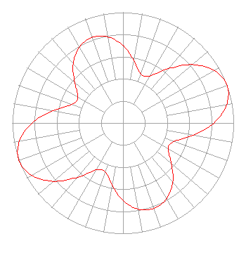 | ||||||||||||||||||||||||
| Azimuth | Ratio | Azimuth | Ratio | Azimuth | Ratio | Azimuth | Ratio | ||||||||||||||||||
| 0 | 0.700 | 10 | 0.570 | 20 | 0.470 | 30 | 0.490 | ||||||||||||||||||
| 40 | 0.640 | 50 | 0.820 | 60 | 0.950 | 70 | 1.000 | ||||||||||||||||||
| 80 | 0.950 | 90 | 0.820 | 100 | 0.640 | 110 | 0.490 | ||||||||||||||||||
| 120 | 0.470 | 130 | 0.570 | 140 | 0.700 | 150 | 0.790 | ||||||||||||||||||
| 160 | 0.820 | 170 | 0.790 | 180 | 0.700 | 190 | 0.570 | ||||||||||||||||||
| 200 | 0.470 | 210 | 0.490 | 220 | 0.640 | 230 | 0.820 | ||||||||||||||||||
| 240 | 0.950 | 250 | 1.000 | 260 | 0.950 | 270 | 0.820 | ||||||||||||||||||
| 280 | 0.640 | 290 | 0.490 | 300 | 0.470 | 310 | 0.570 | ||||||||||||||||||
| 320 | 0.700 | 330 | 0.790 | 340 | 0.820 | 350 | 0.790 | ||||||||||||||||||
Structure Registration Number 1057963 Structure Type: TOWER Registered To: Heartland Tower Company, L.L.C Structure Address: 1.6 Km Ne Of Rtes K42 And C70 Section 25 Plymouth County, IA County Name: Plymouth County ASR Issued: 08/24/2018 Date Built: 02/22/2007 Site Elevation: 406.3 m (1333 ft.) Structure Height: 563 m (1847 ft.) Height Overall: 605.9 m (1988 ft.) Overall Height AMSL: 1012.2 m (3321 ft.) FAA Determination: 02/21/2007 FAA Study #: 2007-ACE-85-OE FAA Circular #: 70/7460-1K Paint & Light FAA Chapters: 4, 7, 12 PRIOR STUDY 1998-ACE-1240-OE 42-35-12.0 N 96-13-19.0 W (NAD 83) 42-35-12.0 N 96-13-17.9 W (Converted to NAD 27) |
1200 Seventeenth Street Nw Washington, DC 20036 Phone: 202-663-8195 Limited Liability Company | Title: Secretary Sinclair Television Group Inc Date: 11/26/2018 Application Certifier KPTH LICENSEE, LLC Kpth Licensee, Llc 10706 Beaver Dam Road Cockeysville, MD 21030 Applicant Paul A. Cicelski, ESQ Lerman Senter Pllc 2001 L Street Nw Suite 400 Washington, DC 20036 John E. Hidle, PE Carl T. Jones Corporation 7901 Yarnwood Court Springfield, VA 22153 Consulting Engineer | |||||||||||||||||||||||
| |||||||||||||||||||||||||