
FCCInfo.com
A Service of Cavell, Mertz & Associates, Inc.
(855) FCC-INFO
|
|
K17MP-D from 12/13/2018 K17MP-D from 10/08/1998 |
|
|
||||||||||||||||
|
|
Status: License Application Accepted: 12/03/2018 License Expires: 08/01/2022 File Number: -0000063903 FCC Website Links: LMS Facility Details This Application Other K17MP-D Applications Including Superseded Applications Mailing Address Correspondence for K17MP-D Correspondence related to application -0000063903 Service Contour - Open Street Map or USGS Map (51 dBu) Service Contour - KML / Google Earth (51 dBu) Rabbit Ears Info Search for K17MP-D Site Location: 32-01-30.0 N 101-58-06.4 W (NAD 83) Site Location: 32-01-29.6 N 101-58-04.9 W (Converted to NAD 27) ERP: 15 kW Polarization: Elliptically polarized Electrical Beam Tilt: 0.75 degrees R/C AGL: 88 m (289 ft.) R/C AMSL: 933.8 m (3064 ft.) Emission Mask: Full Service Site Elevation: 845.8 m. (2775 ft.) Height Overall*: 91.1 m (299 ft.) (* As Filed In This Application, may differ from ASR Data, Below.) Directional Antenna - Antenna Make/Model: Jampro JA/LS-AO-16 Antenna ID: 37185 Polarization: Elliptically polarized | ||||||||||||||||||
| Antenna Data for Antenna Id: 37185 K17MP-D LD File: -0000063903 Jampro - JA/LS-AO-16 Service: LD Standard Pattern: Y Pattern and Field Values Include a 260° Clockwise Rotation | 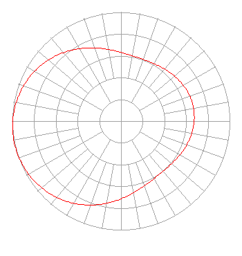 | ||||||||||||||||||
| Azimuth | Ratio | Azimuth | Ratio | Azimuth | Ratio | Azimuth | Ratio | ||||||||||||
| 0 | 0.631 | 10 | 0.609 | 20 | 0.602 | 30 | 0.608 | ||||||||||||
| 40 | 0.623 | 50 | 0.642 | 60 | 0.659 | 70 | 0.672 | ||||||||||||
| 80 | 0.676 | 90 | 0.672 | 100 | 0.659 | 110 | 0.642 | ||||||||||||
| 120 | 0.623 | 130 | 0.608 | 140 | 0.602 | 150 | 0.609 | ||||||||||||
| 160 | 0.631 | 170 | 0.668 | 180 | 0.715 | 190 | 0.767 | ||||||||||||
| 200 | 0.820 | 210 | 0.871 | 220 | 0.915 | 230 | 0.951 | ||||||||||||
| 240 | 0.978 | 250 | 0.994 | 260 | 1.000 | 270 | 0.994 | ||||||||||||
| 280 | 0.978 | 290 | 0.951 | 300 | 0.915 | 310 | 0.871 | ||||||||||||
| 320 | 0.820 | 330 | 0.767 | 340 | 0.715 | 350 | 0.668 | ||||||||||||
Structure Registration Number 1257620 Structure Type: TOWER Registered To: Three Angels Broadcasting Network Structure Address: 1100s County Road 112058 Midland, TX County Name: Midland County ASR Issued: 05/04/2015 Date Built: 03/19/2007 Site Elevation: 845.8 m (2775 ft.) Structure Height: 91.1 m (299 ft.) Height Overall: 91.1 m (299 ft.) Overall Height AMSL: 936.9 m (3074 ft.) FAA Determination: 03/16/2007 FAA Study #: 2007-ASW-1876-OE FAA Circular #: 70/7460-1H Paint & Light FAA Chapters: 3, 4, 5, 13 OM&L to remain the same as prior study = PAINT/RED LIGHTS 32-01-30.0 N 101-58-06.4 W (NAD 83) 32-01-29.6 N 101-58-04.9 W (Converted to NAD 27) |
Po Box 220 West Frankfort, IL 62896 Phone: 618-627-4651 Not-for-Profit | Title: President Date: 12/03/2018 Application Certifier THREE ANGELS BROADCASTING NETWORK, INC. Three Angels Broadcasting Network, Inc. Po Box 220 West Frankfort, IL 62896 Applicant DANIEL N PEEK 3abn P.o. Box 220 West Frankfort, IL 62896 ENGINEER MOSES PRIMO 3abn Po Box 220 West Frankfort, IL 62896 | |||||||||||||||||