
FCCInfo.com
A Service of Cavell, Mertz & Associates, Inc.
(855) FCC-INFO
|
|
K35OU-D from 08/08/2011 K35OU-D from 08/23/1989 |
|
|
||||||||||||||||
|
|
Status: License Application Accepted: 01/28/2019 License Expires: 10/03/2022 File Number: -0000067363 FCC Website Links: LMS Facility Details This Application Other K35OU-D Applications Including Superseded Applications Mailing Address Correspondence for K35OU-D Correspondence related to application -0000067363 Service Contour - Open Street Map or USGS Map (51 dBu) Service Contour - KML / Google Earth (51 dBu) Rabbit Ears Info Search for K35OU-D Site Location: 32-24-54.0 N 110-42-57.9 W (NAD 83) Site Location: 32-24-53.7 N 110-42-55.6 W (Converted to NAD 27) ERP: 9.2 kW Polarization: Elliptically polarized Electrical Beam Tilt: 3.3 degrees R/C AGL: 50 m (164 ft.) R/C AMSL: 2639.1 m (8658 ft.) Emission Mask: Full Service Site Elevation: 2589.1 m. (8494 ft.) Height Overall*: 78.9 m (259 ft.) (* As Filed In This Application, may differ from ASR Data, Below.) Directional Antenna - Antenna Make/Model: Kathrein 75010326 Antenna ID: 1004581 Polarization: Elliptically polarized | ||||||||||||||||||
| Antenna Data for Antenna Id: 1004581 K35OU-D LD File: -0000067363 Kathrein - 75010326 Service: LD Standard Pattern: N Pattern and Field Values Include a 215° Clockwise Rotation | 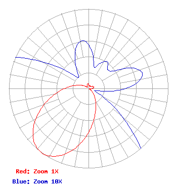 | ||||||||||||||||||
| Azimuth | Ratio | Azimuth | Ratio | Azimuth | Ratio | Azimuth | Ratio | ||||||||||||
| 5 | 0.047 | 15 | 0.028 | 25 | 0.035 | 35 | 0.041 | ||||||||||||
| 45 | 0.034 | 55 | 0.038 | 65 | 0.061 | 75 | 0.070 | ||||||||||||
| 85 | 0.058 | 95 | 0.034 | 105 | 0.011 | 115 | 0.011 | ||||||||||||
| 125 | 0.036 | 135 | 0.079 | 145 | 0.139 | 155 | 0.221 | ||||||||||||
| 165 | 0.327 | 175 | 0.471 | 185 | 0.639 | 195 | 0.807 | ||||||||||||
| 205 | 0.938 | 215 | 1.000 | 225 | 0.962 | 235 | 0.844 | ||||||||||||
| 245 | 0.679 | 255 | 0.512 | 265 | 0.360 | 275 | 0.242 | ||||||||||||
| 285 | 0.153 | 295 | 0.091 | 305 | 0.047 | 315 | 0.020 | ||||||||||||
| 325 | 0.024 | 335 | 0.040 | 345 | 0.056 | 355 | 0.060 | ||||||||||||
Structure Registration Number 1002407 Structure Type: LTOWER Registered To: American Towers LLC Structure Address: Mt. Bigelow, 1.4 Mi. N Of General Hitchcock (bigelow Mt. #9001) Coronado Natl Forest, AZ County Name: Pima County ASR Issued: 05/17/2017 Date Built: 01/01/1988 Site Elevation: 2589.1 m (8494 ft.) Structure Height: 66.4 m (218 ft.) Height Overall: 78.9 m (259 ft.) Overall Height AMSL: 2668 m (8753 ft.) FAA Determination: 10/31/2006 FAA Study #: 2006-AWP-5792-OE FAA Circular #: 70/7460-1K Paint & Light FAA Chapters: 3, 4, 5, 12 PRIOR STUDY 2004-AWP-5531-OE 32-24-54.0 N 110-42-57.9 W (NAD 83) 32-24-53.7 N 110-42-55.6 W (Converted to NAD 27) |
One Hsn Drive St. Petersburg, FL 33729 Phone: 727-872-4210 Corporation | Title: Vice President Date: 01/28/2019 Application Certifier VENTANA TELEVISION, INC. Ventana Television, Inc. One Hsn Drive St. Petersburg, FL 33729 Applicant JOHN COLLINSON Ventana Television, Inc 1 Hsn Drive Saint Petersburg, FL 33729 CERTIFYING ENGINEER ERIC YONKIN Ventana Television Inc. One Hsn Drive 1 Hsn Drive Saint Petersburg, FL 33729 Associate General Counsel | |||||||||||||||||